| | | | | Arrive | Depart |
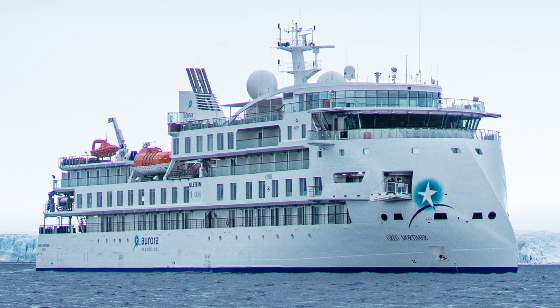
| 20th20 | AugAug | 202626 | Toronto, Ontario, Canada, embark on the Greg Mortimer | | |
Having made your way to Toronto Airport, check-in at our group hotel located near the airport for an overnight stay. Please visit the Aurora Expeditions hospitality desk to collect your luggage cabin tags and to speak with our ground operations team, who may have information to share with you about pre-embarkation procedures and the charter flight to Nuuk tomorrow. You will receive Aurora Expeditions cabin tags for your luggage. Please clearly label the tags with your name and ship cabin number. Accommodation: Westin Toronto Airport Hotel |
| 21st21 | AugAug | 202626 | Nuuk (Godthaab), Greenland | | |
Nuuk, meaning “the cape”, was Greenland’s first town (1728). Started as a fort and later mission and trading post some 240 kilometers south of the Arctic Circle, it is the current capital. Almost 30% of Greenland’s population lives in the town. Not only does Nuuk have great natural beauty in its vicinity, but there are Inuit ruins, Hans Egede’s home, the parliament, and the Church of our Saviour as well. The Greenlandic National Museum has an outstanding collection of Greenlandic traditional dresses, as well as the famous Qilakitsoq mummies. The Katuaq Cultural Center’s building was inspired by the undulating Northern Lights and can house 10% of Nuuk’s inhabitants. This morning, please ensure your cabin luggage is fitted with cabin tags clearly labelled with your name and cabin number. Enjoy breakfast at the hotel before transferring to the airport for our charter flight to Nuuk for embarkation. Any valuables or personal items should be kept on you throughout the day. After boarding, there is time to settle into your cabin before our important safety briefings. This evening, meet your expedition team and crew at the Captain’s Welcome Drinks. |
| 22nd22 | AugAug | 202626 | Sisimiut (Holsteinsborg), Greenland | | |
Located just north of the Arctic Circle, Sisimiut is the northernmost town in Greenland where the port remains free of ice in the winter. Yet it is also the southernmost town where there is enough snow and ice to drive a dogsled in winter and spring. In Sisimiut, travelling by sled has been the primary means of winter transportation for centuries. In fact, the area has been inhabited for approximately 4,500 years. Modern Sisimiut is the largest business center in the north of Greenland, and is one of the fastest growing Greenlandic cities. Commercial fishing is the lead economy in the town‘s thriving industrial base. Greenland’s second largest town, Sisimiut is located approximately 54 kilometres (33.5 miles) north of the Arctic Circle, meaning that during summer, you can experience the midnight sun here. The town is famous for the old blue church with the gate made of whale bone. In the cosy museum next door to the church, you will find an excellent reconstruction of an Inuit turf house as well as exhibits of local history and early life in Greenland. Sisimiut offers hiking trails with various degrees of difficulty. The easier trails take you through the town itself, its outskirts and into the mountains, where you will find spectacular vantage points. Approximately 4,500 years ago, the Saqqaq culture arrived from Canada and settled in the area. They lived here for approximately 2,000 years, after which they mysteriously disappeared from the area. The Dorset culture arrived around 500 CE and stayed until the 1200s until they were replaced by the Thule culture, and today, most of the population of Sisimiut are descendants of the Thule culture. |
| 23rd23 | AugAug | 202626 | Ilulissat (Jakobshavn), Greenland | | |
Known as the birthplace of icebergs, the Ilulissat Icefjord produces nearly 20 million tons of ice each day. In fact, the word Ilulissat means “icebergs” in the Kalaallisut language. The town of Ilulissat is known for its long periods of calm and settled weather, but the climate tends to be cold due to its proximity to the fjord. Approximately 4,500 people live in Ilulissat, the third-largest town in Greenland after Nuuk and Sisimiut. Some people here estimate that there are nearly as many sled dogs as human beings living in the town that also boasts a local history museum located in the former home of Greenlandic folk hero and famed polar explorer Knud Rasmussen. In the afternoon we arrive in Ilulissat. Known as the ‘birthplace of icebergs’, this region produces some of the most dazzling icebergs found anywhere in the Arctic. Hike past the husky sledge dogs to the UNESCO World Heritage-listed Icefjord and stand in awe at its immensity. Sermeq Kujalleq, also known as Jakobshavn Glacier, is the most productive glacier – not only in Greenland but the entire Northern Hemisphere. It produces 20 million tonnes of ice each day, all floating into the Ilulissat Icefjord and Disko Bay. |
| 24th24 | AugAug | 202626 | At Sea | | |
| 25th25 | AugAug | 202626 | At Sea | | |
| 26th26 | AugAug | 202626 | At Sea | | |
| 27th27 | AugAug | 202626 | At Sea | | |
| 28th28 | AugAug | 202626 | Pond Inlet, Nunavut, Canada | | |
Located in northern Baffin Island, Pond Inlet is a small, predo¬minantly Inuit community, with a population of roughly 1,500 inhabitants. In 1818, the British explorer John Ross named a bay in the vicinity after the English astronomer John Pond. Today Pond Inlet is considered one of Canada's "jewels of the North" thanks to several picturesque glaciers and mountain ranges nearby. Many archaeological sites of ancient Dorset and Thule peoples can be found near Pond Inlet. The Inuit hunted caribou, ringed and harp seals, fish, polar bears, walrus, narwhals, geese, ptarmigans and Arctic hares, long before European and American whalers came here to harvest bowhead whales. Pond Inlet is also known as a major center of Inuit art, especially the printmaking and stone carving that are featured in the town’s art galleries. After clearance into Canada, we hope to visit Pond Inlet (Mittimatalik), a captivating Inuit community nestled on the northern tip of Baffin Island. Surrounded by towering ice-capped mountains, vast glaciers, and pristine fjords, this remote outpost offers an unparalleled wilderness experience. As you step ashore, you'll be greeted by the warm hospitality of the local Inuit, whose deep connection to the land is evident in their culture and lifestyle. Immerse yourself in their traditions through engaging cultural encounters and gain insights into their unique perspective on life in the Arctic. |
| 29th29 | AugAug | 202626 | Devon Island, Nunavut, Canada | | |
Devon Island, located in Baffin Bay, is only slightly smaller than Croatia. The eastern side is frosted by the Devon Ice Cap, while on the western half of the island lays the 14 mile wide Haughton impact crater. It was created around 39 million years ago when a meteorite crashed into the land. The landscape surrounding this site resembles the surface of Mars. In fact, for the past decade scientists have conducted research here to determine how humans might live one day on Mars. British Arctic explorers Robert Bylot and William Baffin were the first Europeans to sight the island in 1616. In 1819-1820, William Parry charted the island, naming it North Devon after Devon in England. Despite repeated attempts at trading settlements, the strong wind conditions and cold climate eventually drove everyone away leaving Devon Island as a likely candidate for being the world’s largest uninhabited island. At a latitude of almost 75° degrees north, we are now truly in the High Arctic. Here, nutrient-rich waters support an abundance of wildlife, giving the area the moniker ‘wildlife superhighway’ of the Arctic. Devon Island (Tallurutit) is the largest uninhabited island on Earth and features stunning geology, with flat-topped mountains and glacial valleys giving Devon Island its unique character. We hope to visit Dundas Harbour to enjoy offers walks on undulating tundra, and perhaps some birdwatching. A dilapidated Royal Canadian Mounted Police outpost and remnants of a Hudson’s Bay Company trading post can be found here. In the bay, walruses are often present. Other possible places that we might visit include Croker Bay and Maxwell Bay. At the western end of Devon Island lies Beechey Island (Iluvilik), where we plan to land. Named after Frederick William Beechey, the island is a designated Canadian National Historic Site. During the Franklin expedition of 1845–46, Franklin attempted to sail through the Northwest Passage with HMS Erebus and HMS Terror, with perilous results – three of his men are buried here. Roald Amundsen landed at Beechey Island in 1903, during the first successful voyage by ship to fully transit the Northwest Passage from the Atlantic Ocean to the Pacific Ocean. Just a short distance away, Radstock Bay offers a captivating contrast to the open sea. Here, we’ll disembark via Zodiac onto a beach strewn with remnants of the past. Explore the ruins of a Thule village nestled beneath the imposing Caswell Tower, where well preserved stone dwellings coexist with artifacts from later explorers. Witness the stark beauty of this remote bay, characterised by its dramatic cliffs, gravelly beaches, and the scattered remains of whale skeletons that have shaped the landscape and the lives of those who called it home. |
| 30th30 | AugAug | 202626 | Devon Island, Nunavut, Canada | | |
Devon Island, located in Baffin Bay, is only slightly smaller than Croatia. The eastern side is frosted by the Devon Ice Cap, while on the western half of the island lays the 14 mile wide Haughton impact crater. It was created around 39 million years ago when a meteorite crashed into the land. The landscape surrounding this site resembles the surface of Mars. In fact, for the past decade scientists have conducted research here to determine how humans might live one day on Mars. British Arctic explorers Robert Bylot and William Baffin were the first Europeans to sight the island in 1616. In 1819-1820, William Parry charted the island, naming it North Devon after Devon in England. Despite repeated attempts at trading settlements, the strong wind conditions and cold climate eventually drove everyone away leaving Devon Island as a likely candidate for being the world’s largest uninhabited island. |
| 31st31 | AugAug | 202626 | Lancaster Sound, Tallurutiup Imanga National Park, Nunavut, Canada | | |
| 1st01 | SepSep | 202626 | At Sea | | |
| 2nd02 | SepSep | 202626 | At Sea | | |
| 3rd03 | SepSep | 202626 | At Sea | | |
| 4th04 | SepSep | 202626 | At Sea | | |
| 5th05 | SepSep | 202626 | At Sea | | |
| 6th06 | SepSep | 202626 | Amundsen Gulf, Northwest Territories, Canada | | |
Your experienced expedition team will create your day-by-day itineraries based on sea ice and weather conditions. Apart from Franklin, other heroic explorers including Amundsen explored this territory, and we may visit the same places as early explorers. We hope to meet the resilient locals who make the extreme far north their home. Below are some of the places in the area that we may visit: Johansen Bay, Edinburgh Island (Egloovikan) We hope to enjoy a Zodiac excursion within an estuary of at the northeast end of Johansen Bay and up the river towards the lake. Wildlife including caribous, reindeer, arctic foxes, hares and peregrine falcons frequent the area. Nearby, Edinburgh Island (Egloovikan) is a small and uninhabited island in Canada’s Nunavut region. The scenery consists of colourful flowering shrubs, beaches tinged in stunning ochres, while the surrounding cliffs shaded in rich, deep tones. A possible walk to a lookout overlooking the lake offers spectacular views over lakes, sea and mountains. Port Epworth (Kugluktoalok) The Tree River area on the mainland — also known a Port Epworth — provides a spectacular backdrop our possible exploration, with its river and shallow lakes, striking sedimentary rock outcrops, and bright autumnal colours of tundra. This area is also known for its stromatolites – the petrified remains of ancient mounds of algae, formed some two billion years ago by the same microorganisms responsible for producing the oxygen we breathe today. Smoking Hills (Ingniryuat), Franklin Bay The Smoking Hills (Ingniryuat) in Canada’s Northwest Territories have been smouldering, sending plumes of gas across the landscape, for centuries. Technically sea cliffs, you would be forgiven for thinking that the multicoloured fiery natural phenomenon is the set to an apocalyptic movie depicting the end of the world. The smoke is caused by layers of combustible, sulphur-rich lignite (brown coal) that ignites and emit sulphurous gas into the air, when exposed to erosion and landslides, which also creates a dazzling colouration of the rocks. |
| 7th07 | SepSep | 202626 | Amundsen Gulf, Northwest Territories, Canada | | |
| 8th08 | SepSep | 202626 | Amundsen Gulf, Northwest Territories, Canada | | |
| 9th09 | SepSep | 202626 | Amundsen Gulf, Northwest Territories, Canada | | |
| 10th10 | SepSep | 202626 | Amundsen Gulf, Northwest Territories, Canada | | |
| 11th11 | SepSep | 202626 | At Sea | | |
| 12th12 | SepSep | 202626 | At Sea | | |
| 13th13 | SepSep | 202626 | At Sea | | |
| 14th14 | SepSep | 202626 | At Sea | | |
| 15th15 | SepSep | 202626 | At Sea | | |
| 16th16 | SepSep | 202626 | Nome, Alaska, United States | | |
Nome is located on the edge of the Bering Sea, on the southwest side of the Seward Peninsula. Unlike other towns which are named for explorers, heroes or politicians, Nome was named as a result of a 50 year-old spelling error. In the 1850's an officer on a British ship off the coast of Alaska noted on a manuscript map that a nearby prominent point was not identified. He wrote "? Name" next to the point. When the map was recopied, another draftsman thought that the “?” was a C and that the “a” in "Name" was an o, and thus a map-maker in the British Admiralty christened "Cape Nome." The area has an amazing history dating back 10,000 years of Inupiaq Eskimo use for subsistence living. Modern history started in 1898 when "Three Lucky Swedes”, Jafet Lindberg, Erik Lindblom and John Brynteson, discovered gold in Anvil Creek…the rush was on! In 1899 the population of Nome swelled from a handful to 28,000. Today the population is just over 3,500. Much of Nome's gold rush architecture remains. During the early morning, we cruise into Nome and disembark at approximately 8.00 am. Farewell your Expedition Team before transfer to the airport for a charter flight to Anchorage for an overnight stay. Accommodation: Captain Cook Hotel Anchorage |
| 16th16 | SepSep | 202626 | Anchorage, Alaska, United States | | |
Anchorage is the largest city in Alaska. Located between mountains, it is a beautiful mixture of urban and wilderness. Thanks to its proximity to the Chugach State Park with its 45 species of mammals and the city's rich history, there is so much to be seen in this unique destination. |
| 17th17 | SepSep | 202626 | Anchorage, Alaska, United States, disembark the Greg Mortimer | | |
Anchorage is the largest city in Alaska. Located between mountains, it is a beautiful mixture of urban and wilderness. Thanks to its proximity to the Chugach State Park with its 45 species of mammals and the city's rich history, there is so much to be seen in this unique destination. After breakfast, check-out your hotel and transfer to the airport for your onward journey. |