This site uses cookies as defined in our Cookie Policy, by continuing to use this site you agree to their use.
Continue
Arrive | Depart | ||||||
17th17 | OctOct | 202525 | Port Canaveral, Florida, United States, embark on the Carnival Encounter | 15:30 | |||
Widely known for the Kennedy Space Center, Port Canaveral is located in the city of Cape Canaveral, home to beautiful beaches and Brevard Zoo. | |||||||
17th17 | OctOct | 202525 | Port Canaveral, Florida, United States | 15:30 | |||
Widely known for the Kennedy Space Center, Port Canaveral is located in the city of Cape Canaveral, home to beautiful beaches and Brevard Zoo. | |||||||
17th17 | OctOct | 202525 | Port Canaveral, Florida, United States | 15:30 | |||
Widely known for the Kennedy Space Center, Port Canaveral is located in the city of Cape Canaveral, home to beautiful beaches and Brevard Zoo. | |||||||
17th17 | OctOct | 202525 | Port Canaveral, Florida, United States | 15:30 | |||
Widely known for the Kennedy Space Center, Port Canaveral is located in the city of Cape Canaveral, home to beautiful beaches and Brevard Zoo. | |||||||
17th17 | OctOct | 202525 | Port Canaveral, Florida, United States | 15:30 | |||
Widely known for the Kennedy Space Center, Port Canaveral is located in the city of Cape Canaveral, home to beautiful beaches and Brevard Zoo. | |||||||
17th17 | OctOct | 202525 | Port Canaveral, Florida, United States | 15:30 | |||
Widely known for the Kennedy Space Center, Port Canaveral is located in the city of Cape Canaveral, home to beautiful beaches and Brevard Zoo. | |||||||
17th17 | OctOct | 202525 | Port Canaveral, Florida, United States | 15:30 | |||
Widely known for the Kennedy Space Center, Port Canaveral is located in the city of Cape Canaveral, home to beautiful beaches and Brevard Zoo. | |||||||
17th17 | OctOct | 202525 | Brisbane, Queensland, Australia | 15:00 | |||
Founded in 1824 on the banks of the wide, meandering Brisbane River, the former penal colony of Brisbane was for many years regarded as just a big country town. Many beautiful timber Queenslander homes, built in the 1800s, still dot the riverbanks and inner suburbs, and in spring the city's numerous parks erupt in a riot of colorful jacaranda, poinciana, and bougainvillea blossoms. Today the Queensland capital is one of Australia's most up-and-coming cities: glittering high-rises mark its polished business center, slick fashion boutiques and restaurants abound, and numerous outdoor attractions beckon. In summer, temperatures here are broilingly hot and days are often humid, a reminder that this city is part of a subtropical region. Wear SPF 30-plus sunscreen and a broad-brimmed hat outdoors, even on overcast days.Brisbane's inner suburbs, a 5- to 10-minute drive or 15- to 20-minute walk from the city center, have a mix of intriguing eateries and quiet accommodations. Fortitude Valley combines Chinatown with a cosmopolitan mix of clubs, cafés, and boutiques. Spring Hill has several high-quality hotels, and Paddington, New Farm, Petrie Terrace, West End, and Woolloongabba are full of an eclectic mix of restaurants and bars. Brisbane is also a convenient base for trips to the Sunshine and Gold coasts, the mountainous hinterlands, and the Moreton Bay islands. | |||||||
17th17 | OctOct | 202525 | Port Canaveral, Florida, United States | 15:30 | |||
Widely known for the Kennedy Space Center, Port Canaveral is located in the city of Cape Canaveral, home to beautiful beaches and Brevard Zoo. | |||||||
17th17 | OctOct | 202525 | Port Canaveral, Florida, United States | 15:30 | |||
Widely known for the Kennedy Space Center, Port Canaveral is located in the city of Cape Canaveral, home to beautiful beaches and Brevard Zoo. | |||||||
17th17 | OctOct | 202525 | Port Canaveral, Florida, United States | 15:30 | |||
Widely known for the Kennedy Space Center, Port Canaveral is located in the city of Cape Canaveral, home to beautiful beaches and Brevard Zoo. | |||||||
18th18 | OctOct | 202525 | Nassau, Bahamas | 10:00 | 18:00 | ||
Nassau's sheltered harbor bustles with cruise-ship activity, while a block away Bay Street's sidewalks are crowded with shoppers who duck into air-conditioned boutiques and relax on benches in the shade of mahogany and lignum vitae trees. Shops angle for tourist dollars with fine imported goods at duty-free prices, yet you'll find a handful of stores overflowing with authentic Bahamian crafts, food supplies, and other delights. With a revitalization of downtown ongoing—the revamped British Colonial Hilton leading the way—Nassau is recapturing some of its past glamour. Nevertheless, modern influences are completely apparent: fancy restaurants, suave clubs, and trendy coffeehouses have popped up everywhere. These changes have come partly in response to the growing number of upper-crust crowds that now supplement the spring breakers and cruise passengers who have traditionally flocked to Nassau. Of course, you can still find a wild club or a rowdy bar, but you can also sip cappuccino while viewing contemporary Bahamian art or dine by candlelight beneath prints of old Nassau, serenaded by soft, island-inspired calypso music. A trip to Nassau wouldn't be complete without a stop at some of the island's well-preserved historic buildings. The large, pink colonial-style edifices house Parliament and some of the courts, while others, like Fort Charlotte, date back to the days when pirates ruled the town. Take a tour via horse-drawn carriage for the full effect. | |||||||
19th19 | OctOct | 202525 | Grand Turk Island, Turks and Caicos Islands | 09:00 | 18:00 | ||
Just 7 miles (11 km) long and a little more than 1 mile (1½ km) wide, this island, the capital and seat of the Turks and Caicos government, has been a longtime favorite destination for divers eager to explore the 7,000-foot-deep pristine coral walls that drop down only 300 yards out to sea. On shore, the tiny, quiet island is home to white-sand beaches, the National Museum, and a small population of wild horses and donkeys, which leisurely meander past the white-walled courtyards, pretty churches, and bougainvillea-covered colonial inns on their daily commute into town. But things aren't entirely sleepy: a cruise-ship complex at the southern end of the island brings about 600,000 visitors per year. That said, the dock is self-contained and is about 3 miles (5 km) from the tranquil, small hotels of Cockburn Town, Pillory Beach, and the Ridge and far from most of the western-shore dive sites. Pristine beaches with vistas of turquoise waters, small local settlements, historic ruins, and native flora and fauna are among the sights on Grand Turk. Fewer than 4,000 people live on this 7½-square-mile (19-square-km) island, and it's hard to get lost, as there aren't many roads. | |||||||
19th19 | OctOct | 202525 | Amber Cove, Dominican Republic | 10:00 | 18:00 | ||
19th19 | OctOct | 202525 | Amber Cove, Dominican Republic | 18:00 | |||
19th19 | OctOct | 202525 | Grand Turk Island, Turks and Caicos Islands | 08:00 | 16:00 | ||
Just 7 miles (11 km) long and a little more than 1 mile (1½ km) wide, this island, the capital and seat of the Turks and Caicos government, has been a longtime favorite destination for divers eager to explore the 7,000-foot-deep pristine coral walls that drop down only 300 yards out to sea. On shore, the tiny, quiet island is home to white-sand beaches, the National Museum, and a small population of wild horses and donkeys, which leisurely meander past the white-walled courtyards, pretty churches, and bougainvillea-covered colonial inns on their daily commute into town. But things aren't entirely sleepy: a cruise-ship complex at the southern end of the island brings about 600,000 visitors per year. That said, the dock is self-contained and is about 3 miles (5 km) from the tranquil, small hotels of Cockburn Town, Pillory Beach, and the Ridge and far from most of the western-shore dive sites. Pristine beaches with vistas of turquoise waters, small local settlements, historic ruins, and native flora and fauna are among the sights on Grand Turk. Fewer than 4,000 people live on this 7½-square-mile (19-square-km) island, and it's hard to get lost, as there aren't many roads. | |||||||
19th19 | OctOct | 202525 | Grand Turk Island, Turks and Caicos Islands | 17:00 | |||
Just 7 miles (11 km) long and a little more than 1 mile (1½ km) wide, this island, the capital and seat of the Turks and Caicos government, has been a longtime favorite destination for divers eager to explore the 7,000-foot-deep pristine coral walls that drop down only 300 yards out to sea. On shore, the tiny, quiet island is home to white-sand beaches, the National Museum, and a small population of wild horses and donkeys, which leisurely meander past the white-walled courtyards, pretty churches, and bougainvillea-covered colonial inns on their daily commute into town. But things aren't entirely sleepy: a cruise-ship complex at the southern end of the island brings about 600,000 visitors per year. That said, the dock is self-contained and is about 3 miles (5 km) from the tranquil, small hotels of Cockburn Town, Pillory Beach, and the Ridge and far from most of the western-shore dive sites. Pristine beaches with vistas of turquoise waters, small local settlements, historic ruins, and native flora and fauna are among the sights on Grand Turk. Fewer than 4,000 people live on this 7½-square-mile (19-square-km) island, and it's hard to get lost, as there aren't many roads. | |||||||
20th20 | OctOct | 202525 | Saint Thomas, U.S. Virgin Islands | 09:00 | 18:00 | ||
If you fly to the 32-square-mile (83-square-km) island of St. Thomas, you land at its western end; if you arrive by cruise ship, you come into one of the world's most beautiful harbors. Either way, one of your first sights is the town of Charlotte Amalie. From the harbor you see an idyllic-looking village that spreads into the lower hills. If you were expecting a quiet hamlet with its inhabitants hanging out under palm trees, you've missed that era by about 300 years. Although other islands in the USVI developed plantation economies, St. Thomas cultivated its harbor, and it became a thriving seaport soon after it was settled by the Danish in the 1600s. The success of the naturally perfect harbor was enhanced by the fact that the Danes—who ruled St. Thomas with only a couple of short interruptions from 1666 to 1917—avoided involvement in some 100 years' worth of European wars. Denmark was the only European country with colonies in the Caribbean to stay neutral during the War of the Spanish Succession in the early 1700s. Thus, products of the Dutch, English, and French islands—sugar, cotton, and indigo—were traded through Charlotte Amalie, along with the regular shipments of slaves. When the Spanish wars ended, trade fell off, but by the end of the 1700s Europe was at war again, Denmark again remained neutral, and St. Thomas continued to prosper. Even into the 1800s, while the economies of St. Croix and St. John foundered with the market for sugarcane, St. Thomas's economy remained vigorous. This prosperity led to the development of shipyards, a well-organized banking system, and a large merchant class. In 1845 Charlotte Amalie had 101 large importing houses owned by the English, French, Germans, Haitians, Spaniards, Americans, Sephardim, and Danes. Charlotte Amalie is still one of the world's most active cruise-ship ports. On almost any day at least one and sometimes as many as eight cruise ships are tied to the docks or anchored outside the harbor. Gently rocking in the shadows of these giant floating hotels are just about every other kind of vessel imaginable: sleek sailing catamarans that will take you on a sunset cruise complete with rum punch and a Jimmy Buffett soundtrack, private megayachts for billionaires, and barnacle-bottom sloops—with laundry draped over the lifelines—that are home to world-cruising gypsies. Huge container ships pull up in Sub Base, west of the harbor, bringing in everything from breakfast cereals to tires. Anchored right along the waterfront are down-island barges that ply the waters between the Greater Antilles and the Leeward Islands, transporting goods such as refrigerators, VCRs, and disposable diapers. The waterfront road through Charlotte Amalie was once part of the harbor. Before it was filled in to build the highway, the beach came right up to the back door of the warehouses that now line the thoroughfare. Two hundred years ago those warehouses were filled with indigo, tobacco, and cotton. Today the stone buildings house silk, crystal, and diamonds. Exotic fragrances are still traded, but by island beauty queens in air-conditioned perfume palaces instead of through open market stalls. The pirates of old used St. Thomas as a base from which to raid merchant ships of every nation, though they were particularly fond of the gold- and silver-laden treasure ships heading to Spain. Pirates are still around, but today's versions use St. Thomas as a drop-off for their contraband: illegal immigrants and drugs. To explore outside Charlotte Amalie, rent a car or hire a taxi. Your rental car should come with a good map; if not, pick up the pocket-size "St. Thomas–St. John Road Map" at a tourist information center. Roads are marked with route numbers, but they're confusing and seem to switch numbers suddenly. Roads are also identified by signs bearing the St. Thomas–St. John Hotel and Tourism Association's mascot, Tommy the Starfish. More than 100 of these color-coded signs line the island's main routes. Orange signs trace the route from the airport to Red Hook, green signs identify the road from town to Magens Bay, Tommy's face on a yellow background points from Mafolie to Crown Bay through the north side, red signs lead from Smith Bay to Four Corners via Skyline Drive, and blue signs mark the route from the cruise-ship dock at Havensight to Red Hook. These color-coded routes are not marked on most visitor maps, however. Allow yourself a day to explore, especially if you want to stop to take pictures or to enjoy a light bite or refreshing swim. Most gas stations are on the island's more populated eastern end, so fill up before heading to the north side. And remember to drive on the left! | |||||||
20th20 | OctOct | 202525 | Saint Thomas, U.S. Virgin Islands | 18:00 | |||
If you fly to the 32-square-mile (83-square-km) island of St. Thomas, you land at its western end; if you arrive by cruise ship, you come into one of the world's most beautiful harbors. Either way, one of your first sights is the town of Charlotte Amalie. From the harbor you see an idyllic-looking village that spreads into the lower hills. If you were expecting a quiet hamlet with its inhabitants hanging out under palm trees, you've missed that era by about 300 years. Although other islands in the USVI developed plantation economies, St. Thomas cultivated its harbor, and it became a thriving seaport soon after it was settled by the Danish in the 1600s. The success of the naturally perfect harbor was enhanced by the fact that the Danes—who ruled St. Thomas with only a couple of short interruptions from 1666 to 1917—avoided involvement in some 100 years' worth of European wars. Denmark was the only European country with colonies in the Caribbean to stay neutral during the War of the Spanish Succession in the early 1700s. Thus, products of the Dutch, English, and French islands—sugar, cotton, and indigo—were traded through Charlotte Amalie, along with the regular shipments of slaves. When the Spanish wars ended, trade fell off, but by the end of the 1700s Europe was at war again, Denmark again remained neutral, and St. Thomas continued to prosper. Even into the 1800s, while the economies of St. Croix and St. John foundered with the market for sugarcane, St. Thomas's economy remained vigorous. This prosperity led to the development of shipyards, a well-organized banking system, and a large merchant class. In 1845 Charlotte Amalie had 101 large importing houses owned by the English, French, Germans, Haitians, Spaniards, Americans, Sephardim, and Danes. Charlotte Amalie is still one of the world's most active cruise-ship ports. On almost any day at least one and sometimes as many as eight cruise ships are tied to the docks or anchored outside the harbor. Gently rocking in the shadows of these giant floating hotels are just about every other kind of vessel imaginable: sleek sailing catamarans that will take you on a sunset cruise complete with rum punch and a Jimmy Buffett soundtrack, private megayachts for billionaires, and barnacle-bottom sloops—with laundry draped over the lifelines—that are home to world-cruising gypsies. Huge container ships pull up in Sub Base, west of the harbor, bringing in everything from breakfast cereals to tires. Anchored right along the waterfront are down-island barges that ply the waters between the Greater Antilles and the Leeward Islands, transporting goods such as refrigerators, VCRs, and disposable diapers. The waterfront road through Charlotte Amalie was once part of the harbor. Before it was filled in to build the highway, the beach came right up to the back door of the warehouses that now line the thoroughfare. Two hundred years ago those warehouses were filled with indigo, tobacco, and cotton. Today the stone buildings house silk, crystal, and diamonds. Exotic fragrances are still traded, but by island beauty queens in air-conditioned perfume palaces instead of through open market stalls. The pirates of old used St. Thomas as a base from which to raid merchant ships of every nation, though they were particularly fond of the gold- and silver-laden treasure ships heading to Spain. Pirates are still around, but today's versions use St. Thomas as a drop-off for their contraband: illegal immigrants and drugs. To explore outside Charlotte Amalie, rent a car or hire a taxi. Your rental car should come with a good map; if not, pick up the pocket-size "St. Thomas–St. John Road Map" at a tourist information center. Roads are marked with route numbers, but they're confusing and seem to switch numbers suddenly. Roads are also identified by signs bearing the St. Thomas–St. John Hotel and Tourism Association's mascot, Tommy the Starfish. More than 100 of these color-coded signs line the island's main routes. Orange signs trace the route from the airport to Red Hook, green signs identify the road from town to Magens Bay, Tommy's face on a yellow background points from Mafolie to Crown Bay through the north side, red signs lead from Smith Bay to Four Corners via Skyline Drive, and blue signs mark the route from the cruise-ship dock at Havensight to Red Hook. These color-coded routes are not marked on most visitor maps, however. Allow yourself a day to explore, especially if you want to stop to take pictures or to enjoy a light bite or refreshing swim. Most gas stations are on the island's more populated eastern end, so fill up before heading to the north side. And remember to drive on the left! | |||||||
20th20 | OctOct | 202525 | San Juan (Puerto Rico), Puerto Rico | 13:00 | 20:00 | ||
If you associate Puerto Rico's capital with the colonial streets of Old San Juan, then you know only part of the picture. San Juan is a major metropolis, radiating out from the bay on the Atlantic Ocean that was discovered by Juan Ponce de León. More than a third of the island's nearly 4 million citizens proudly call themselves sanjuaneros. The city may be rooted in the past, but it has its eye on the future. Locals go about their business surrounded by colonial architecture and towering modern structures.By 1508 the explorer Juan Ponce de León had established a colony in an area now known as Caparra, southeast of present-day San Juan. He later moved the settlement north to a more hospitable peninsular location. In 1521, after he became the first colonial governor, Ponce de León switched the name of the island—which was then called San Juan Bautista in honor of St. John the Baptist—with that of the settlement of Puerto Rico ("rich port").Defended by the imposing Castillo San Felipe del Morro (El Morro) and Castillo San Cristóbal, Puerto Rico's administrative and population center remained firmly in Spain's hands until 1898, when it came under U.S. control after the Spanish-American War. Centuries of Spanish rule left an indelible imprint on the city, particularly in the walled area now known as Old San Juan. The area is filled with cobblestone streets and brightly painted, colonial-era structures, and its fortifications have been designated a UNESCO World Heritage Site.Old San Juan is a monument to the past, but most of the rest of the city is planted firmly in the 21st century and draws migrants island-wide and from farther afield to jobs in its businesses and industries. The city captivates residents and visitors alike with its vibrant lifestyle as well as its balmy beaches, pulsing nightclubs, globe-spanning restaurants, and world-class museums. Once you set foot in this city, you may never want to leave. | |||||||
20th20 | OctOct | 202525 | San Juan (Puerto Rico), Puerto Rico | 18:00 | |||
If you associate Puerto Rico's capital with the colonial streets of Old San Juan, then you know only part of the picture. San Juan is a major metropolis, radiating out from the bay on the Atlantic Ocean that was discovered by Juan Ponce de León. More than a third of the island's nearly 4 million citizens proudly call themselves sanjuaneros. The city may be rooted in the past, but it has its eye on the future. Locals go about their business surrounded by colonial architecture and towering modern structures.By 1508 the explorer Juan Ponce de León had established a colony in an area now known as Caparra, southeast of present-day San Juan. He later moved the settlement north to a more hospitable peninsular location. In 1521, after he became the first colonial governor, Ponce de León switched the name of the island—which was then called San Juan Bautista in honor of St. John the Baptist—with that of the settlement of Puerto Rico ("rich port").Defended by the imposing Castillo San Felipe del Morro (El Morro) and Castillo San Cristóbal, Puerto Rico's administrative and population center remained firmly in Spain's hands until 1898, when it came under U.S. control after the Spanish-American War. Centuries of Spanish rule left an indelible imprint on the city, particularly in the walled area now known as Old San Juan. The area is filled with cobblestone streets and brightly painted, colonial-era structures, and its fortifications have been designated a UNESCO World Heritage Site.Old San Juan is a monument to the past, but most of the rest of the city is planted firmly in the 21st century and draws migrants island-wide and from farther afield to jobs in its businesses and industries. The city captivates residents and visitors alike with its vibrant lifestyle as well as its balmy beaches, pulsing nightclubs, globe-spanning restaurants, and world-class museums. Once you set foot in this city, you may never want to leave. | |||||||
20th20 | OctOct | 202525 | Amber Cove, Dominican Republic | 08:00 | 17:00 | ||
20th20 | OctOct | 202525 | Curaçao, Curaçao | 14:00 | 22:00 | ||
20th20 | OctOct | 202525 | San Juan (Puerto Rico), Puerto Rico | 10:00 | 18:00 | ||
If you associate Puerto Rico's capital with the colonial streets of Old San Juan, then you know only part of the picture. San Juan is a major metropolis, radiating out from the bay on the Atlantic Ocean that was discovered by Juan Ponce de León. More than a third of the island's nearly 4 million citizens proudly call themselves sanjuaneros. The city may be rooted in the past, but it has its eye on the future. Locals go about their business surrounded by colonial architecture and towering modern structures.By 1508 the explorer Juan Ponce de León had established a colony in an area now known as Caparra, southeast of present-day San Juan. He later moved the settlement north to a more hospitable peninsular location. In 1521, after he became the first colonial governor, Ponce de León switched the name of the island—which was then called San Juan Bautista in honor of St. John the Baptist—with that of the settlement of Puerto Rico ("rich port").Defended by the imposing Castillo San Felipe del Morro (El Morro) and Castillo San Cristóbal, Puerto Rico's administrative and population center remained firmly in Spain's hands until 1898, when it came under U.S. control after the Spanish-American War. Centuries of Spanish rule left an indelible imprint on the city, particularly in the walled area now known as Old San Juan. The area is filled with cobblestone streets and brightly painted, colonial-era structures, and its fortifications have been designated a UNESCO World Heritage Site.Old San Juan is a monument to the past, but most of the rest of the city is planted firmly in the 21st century and draws migrants island-wide and from farther afield to jobs in its businesses and industries. The city captivates residents and visitors alike with its vibrant lifestyle as well as its balmy beaches, pulsing nightclubs, globe-spanning restaurants, and world-class museums. Once you set foot in this city, you may never want to leave. | |||||||
20th20 | OctOct | 202525 | Grand Turk Island, Turks and Caicos Islands | 08:00 | 17:00 | ||
Just 7 miles (11 km) long and a little more than 1 mile (1½ km) wide, this island, the capital and seat of the Turks and Caicos government, has been a longtime favorite destination for divers eager to explore the 7,000-foot-deep pristine coral walls that drop down only 300 yards out to sea. On shore, the tiny, quiet island is home to white-sand beaches, the National Museum, and a small population of wild horses and donkeys, which leisurely meander past the white-walled courtyards, pretty churches, and bougainvillea-covered colonial inns on their daily commute into town. But things aren't entirely sleepy: a cruise-ship complex at the southern end of the island brings about 600,000 visitors per year. That said, the dock is self-contained and is about 3 miles (5 km) from the tranquil, small hotels of Cockburn Town, Pillory Beach, and the Ridge and far from most of the western-shore dive sites. Pristine beaches with vistas of turquoise waters, small local settlements, historic ruins, and native flora and fauna are among the sights on Grand Turk. Fewer than 4,000 people live on this 7½-square-mile (19-square-km) island, and it's hard to get lost, as there aren't many roads. | |||||||
20th20 | OctOct | 202525 | Saint Thomas, U.S. Virgin Islands | 09:00 | 18:00 | ||
If you fly to the 32-square-mile (83-square-km) island of St. Thomas, you land at its western end; if you arrive by cruise ship, you come into one of the world's most beautiful harbors. Either way, one of your first sights is the town of Charlotte Amalie. From the harbor you see an idyllic-looking village that spreads into the lower hills. If you were expecting a quiet hamlet with its inhabitants hanging out under palm trees, you've missed that era by about 300 years. Although other islands in the USVI developed plantation economies, St. Thomas cultivated its harbor, and it became a thriving seaport soon after it was settled by the Danish in the 1600s. The success of the naturally perfect harbor was enhanced by the fact that the Danes—who ruled St. Thomas with only a couple of short interruptions from 1666 to 1917—avoided involvement in some 100 years' worth of European wars. Denmark was the only European country with colonies in the Caribbean to stay neutral during the War of the Spanish Succession in the early 1700s. Thus, products of the Dutch, English, and French islands—sugar, cotton, and indigo—were traded through Charlotte Amalie, along with the regular shipments of slaves. When the Spanish wars ended, trade fell off, but by the end of the 1700s Europe was at war again, Denmark again remained neutral, and St. Thomas continued to prosper. Even into the 1800s, while the economies of St. Croix and St. John foundered with the market for sugarcane, St. Thomas's economy remained vigorous. This prosperity led to the development of shipyards, a well-organized banking system, and a large merchant class. In 1845 Charlotte Amalie had 101 large importing houses owned by the English, French, Germans, Haitians, Spaniards, Americans, Sephardim, and Danes. Charlotte Amalie is still one of the world's most active cruise-ship ports. On almost any day at least one and sometimes as many as eight cruise ships are tied to the docks or anchored outside the harbor. Gently rocking in the shadows of these giant floating hotels are just about every other kind of vessel imaginable: sleek sailing catamarans that will take you on a sunset cruise complete with rum punch and a Jimmy Buffett soundtrack, private megayachts for billionaires, and barnacle-bottom sloops—with laundry draped over the lifelines—that are home to world-cruising gypsies. Huge container ships pull up in Sub Base, west of the harbor, bringing in everything from breakfast cereals to tires. Anchored right along the waterfront are down-island barges that ply the waters between the Greater Antilles and the Leeward Islands, transporting goods such as refrigerators, VCRs, and disposable diapers. The waterfront road through Charlotte Amalie was once part of the harbor. Before it was filled in to build the highway, the beach came right up to the back door of the warehouses that now line the thoroughfare. Two hundred years ago those warehouses were filled with indigo, tobacco, and cotton. Today the stone buildings house silk, crystal, and diamonds. Exotic fragrances are still traded, but by island beauty queens in air-conditioned perfume palaces instead of through open market stalls. The pirates of old used St. Thomas as a base from which to raid merchant ships of every nation, though they were particularly fond of the gold- and silver-laden treasure ships heading to Spain. Pirates are still around, but today's versions use St. Thomas as a drop-off for their contraband: illegal immigrants and drugs. To explore outside Charlotte Amalie, rent a car or hire a taxi. Your rental car should come with a good map; if not, pick up the pocket-size "St. Thomas–St. John Road Map" at a tourist information center. Roads are marked with route numbers, but they're confusing and seem to switch numbers suddenly. Roads are also identified by signs bearing the St. Thomas–St. John Hotel and Tourism Association's mascot, Tommy the Starfish. More than 100 of these color-coded signs line the island's main routes. Orange signs trace the route from the airport to Red Hook, green signs identify the road from town to Magens Bay, Tommy's face on a yellow background points from Mafolie to Crown Bay through the north side, red signs lead from Smith Bay to Four Corners via Skyline Drive, and blue signs mark the route from the cruise-ship dock at Havensight to Red Hook. These color-coded routes are not marked on most visitor maps, however. Allow yourself a day to explore, especially if you want to stop to take pictures or to enjoy a light bite or refreshing swim. Most gas stations are on the island's more populated eastern end, so fill up before heading to the north side. And remember to drive on the left! | |||||||
20th20 | OctOct | 202525 | Amber Cove, Dominican Republic | 07:00 | 16:00 | ||
20th20 | OctOct | 202525 | Nouméa, New Caledonia | 08:00 | 17:00 | ||
With its elegant urban infrastructure in a stunning natural setting, Noumea is a truly unique island and part of the New Caledonia archipelago. Noumea started as a penal colony, but has since evolved to a lovely metropolis and today has almost two thirds of New Caledonia’s population. While much of the archipelago of New Caledonia has a large percentage of Kanak people – the indigenous inhabitants who live in tribal areas across the country – Noumea is predominantly European with a strong French influence. The city’s center and Place de Cocotiers, the main park, are located close to the harbor and several churches date back to the late 19th century. Other attractions include a world-class aquarium at Anse Vata, several long beaches to the south, and a noteworthy collection of Kanak and South Pacific objects at the Museum of New Caledonia. The architectural gem of the city is the Tjibaou Cultural Center, the structure of which resembles sails, or the roofs of Kanak houses hidden behind mangroves. | |||||||
21st21 | OctOct | 202525 | San Juan (Puerto Rico), Puerto Rico | 07:00 | 16:00 | ||
If you associate Puerto Rico's capital with the colonial streets of Old San Juan, then you know only part of the picture. San Juan is a major metropolis, radiating out from the bay on the Atlantic Ocean that was discovered by Juan Ponce de León. More than a third of the island's nearly 4 million citizens proudly call themselves sanjuaneros. The city may be rooted in the past, but it has its eye on the future. Locals go about their business surrounded by colonial architecture and towering modern structures.By 1508 the explorer Juan Ponce de León had established a colony in an area now known as Caparra, southeast of present-day San Juan. He later moved the settlement north to a more hospitable peninsular location. In 1521, after he became the first colonial governor, Ponce de León switched the name of the island—which was then called San Juan Bautista in honor of St. John the Baptist—with that of the settlement of Puerto Rico ("rich port").Defended by the imposing Castillo San Felipe del Morro (El Morro) and Castillo San Cristóbal, Puerto Rico's administrative and population center remained firmly in Spain's hands until 1898, when it came under U.S. control after the Spanish-American War. Centuries of Spanish rule left an indelible imprint on the city, particularly in the walled area now known as Old San Juan. The area is filled with cobblestone streets and brightly painted, colonial-era structures, and its fortifications have been designated a UNESCO World Heritage Site.Old San Juan is a monument to the past, but most of the rest of the city is planted firmly in the 21st century and draws migrants island-wide and from farther afield to jobs in its businesses and industries. The city captivates residents and visitors alike with its vibrant lifestyle as well as its balmy beaches, pulsing nightclubs, globe-spanning restaurants, and world-class museums. Once you set foot in this city, you may never want to leave. | |||||||
21st21 | OctOct | 202525 | Aruba, Aruba | 08:00 | 16:00 | ||
21st21 | OctOct | 202525 | Saint Thomas, U.S. Virgin Islands | 07:00 | 16:00 | ||
If you fly to the 32-square-mile (83-square-km) island of St. Thomas, you land at its western end; if you arrive by cruise ship, you come into one of the world's most beautiful harbors. Either way, one of your first sights is the town of Charlotte Amalie. From the harbor you see an idyllic-looking village that spreads into the lower hills. If you were expecting a quiet hamlet with its inhabitants hanging out under palm trees, you've missed that era by about 300 years. Although other islands in the USVI developed plantation economies, St. Thomas cultivated its harbor, and it became a thriving seaport soon after it was settled by the Danish in the 1600s. The success of the naturally perfect harbor was enhanced by the fact that the Danes—who ruled St. Thomas with only a couple of short interruptions from 1666 to 1917—avoided involvement in some 100 years' worth of European wars. Denmark was the only European country with colonies in the Caribbean to stay neutral during the War of the Spanish Succession in the early 1700s. Thus, products of the Dutch, English, and French islands—sugar, cotton, and indigo—were traded through Charlotte Amalie, along with the regular shipments of slaves. When the Spanish wars ended, trade fell off, but by the end of the 1700s Europe was at war again, Denmark again remained neutral, and St. Thomas continued to prosper. Even into the 1800s, while the economies of St. Croix and St. John foundered with the market for sugarcane, St. Thomas's economy remained vigorous. This prosperity led to the development of shipyards, a well-organized banking system, and a large merchant class. In 1845 Charlotte Amalie had 101 large importing houses owned by the English, French, Germans, Haitians, Spaniards, Americans, Sephardim, and Danes. Charlotte Amalie is still one of the world's most active cruise-ship ports. On almost any day at least one and sometimes as many as eight cruise ships are tied to the docks or anchored outside the harbor. Gently rocking in the shadows of these giant floating hotels are just about every other kind of vessel imaginable: sleek sailing catamarans that will take you on a sunset cruise complete with rum punch and a Jimmy Buffett soundtrack, private megayachts for billionaires, and barnacle-bottom sloops—with laundry draped over the lifelines—that are home to world-cruising gypsies. Huge container ships pull up in Sub Base, west of the harbor, bringing in everything from breakfast cereals to tires. Anchored right along the waterfront are down-island barges that ply the waters between the Greater Antilles and the Leeward Islands, transporting goods such as refrigerators, VCRs, and disposable diapers. The waterfront road through Charlotte Amalie was once part of the harbor. Before it was filled in to build the highway, the beach came right up to the back door of the warehouses that now line the thoroughfare. Two hundred years ago those warehouses were filled with indigo, tobacco, and cotton. Today the stone buildings house silk, crystal, and diamonds. Exotic fragrances are still traded, but by island beauty queens in air-conditioned perfume palaces instead of through open market stalls. The pirates of old used St. Thomas as a base from which to raid merchant ships of every nation, though they were particularly fond of the gold- and silver-laden treasure ships heading to Spain. Pirates are still around, but today's versions use St. Thomas as a drop-off for their contraband: illegal immigrants and drugs. To explore outside Charlotte Amalie, rent a car or hire a taxi. Your rental car should come with a good map; if not, pick up the pocket-size "St. Thomas–St. John Road Map" at a tourist information center. Roads are marked with route numbers, but they're confusing and seem to switch numbers suddenly. Roads are also identified by signs bearing the St. Thomas–St. John Hotel and Tourism Association's mascot, Tommy the Starfish. More than 100 of these color-coded signs line the island's main routes. Orange signs trace the route from the airport to Red Hook, green signs identify the road from town to Magens Bay, Tommy's face on a yellow background points from Mafolie to Crown Bay through the north side, red signs lead from Smith Bay to Four Corners via Skyline Drive, and blue signs mark the route from the cruise-ship dock at Havensight to Red Hook. These color-coded routes are not marked on most visitor maps, however. Allow yourself a day to explore, especially if you want to stop to take pictures or to enjoy a light bite or refreshing swim. Most gas stations are on the island's more populated eastern end, so fill up before heading to the north side. And remember to drive on the left! | |||||||
21st21 | OctOct | 202525 | Saint Thomas, U.S. Virgin Islands | 16:00 | |||
If you fly to the 32-square-mile (83-square-km) island of St. Thomas, you land at its western end; if you arrive by cruise ship, you come into one of the world's most beautiful harbors. Either way, one of your first sights is the town of Charlotte Amalie. From the harbor you see an idyllic-looking village that spreads into the lower hills. If you were expecting a quiet hamlet with its inhabitants hanging out under palm trees, you've missed that era by about 300 years. Although other islands in the USVI developed plantation economies, St. Thomas cultivated its harbor, and it became a thriving seaport soon after it was settled by the Danish in the 1600s. The success of the naturally perfect harbor was enhanced by the fact that the Danes—who ruled St. Thomas with only a couple of short interruptions from 1666 to 1917—avoided involvement in some 100 years' worth of European wars. Denmark was the only European country with colonies in the Caribbean to stay neutral during the War of the Spanish Succession in the early 1700s. Thus, products of the Dutch, English, and French islands—sugar, cotton, and indigo—were traded through Charlotte Amalie, along with the regular shipments of slaves. When the Spanish wars ended, trade fell off, but by the end of the 1700s Europe was at war again, Denmark again remained neutral, and St. Thomas continued to prosper. Even into the 1800s, while the economies of St. Croix and St. John foundered with the market for sugarcane, St. Thomas's economy remained vigorous. This prosperity led to the development of shipyards, a well-organized banking system, and a large merchant class. In 1845 Charlotte Amalie had 101 large importing houses owned by the English, French, Germans, Haitians, Spaniards, Americans, Sephardim, and Danes. Charlotte Amalie is still one of the world's most active cruise-ship ports. On almost any day at least one and sometimes as many as eight cruise ships are tied to the docks or anchored outside the harbor. Gently rocking in the shadows of these giant floating hotels are just about every other kind of vessel imaginable: sleek sailing catamarans that will take you on a sunset cruise complete with rum punch and a Jimmy Buffett soundtrack, private megayachts for billionaires, and barnacle-bottom sloops—with laundry draped over the lifelines—that are home to world-cruising gypsies. Huge container ships pull up in Sub Base, west of the harbor, bringing in everything from breakfast cereals to tires. Anchored right along the waterfront are down-island barges that ply the waters between the Greater Antilles and the Leeward Islands, transporting goods such as refrigerators, VCRs, and disposable diapers. The waterfront road through Charlotte Amalie was once part of the harbor. Before it was filled in to build the highway, the beach came right up to the back door of the warehouses that now line the thoroughfare. Two hundred years ago those warehouses were filled with indigo, tobacco, and cotton. Today the stone buildings house silk, crystal, and diamonds. Exotic fragrances are still traded, but by island beauty queens in air-conditioned perfume palaces instead of through open market stalls. The pirates of old used St. Thomas as a base from which to raid merchant ships of every nation, though they were particularly fond of the gold- and silver-laden treasure ships heading to Spain. Pirates are still around, but today's versions use St. Thomas as a drop-off for their contraband: illegal immigrants and drugs. To explore outside Charlotte Amalie, rent a car or hire a taxi. Your rental car should come with a good map; if not, pick up the pocket-size "St. Thomas–St. John Road Map" at a tourist information center. Roads are marked with route numbers, but they're confusing and seem to switch numbers suddenly. Roads are also identified by signs bearing the St. Thomas–St. John Hotel and Tourism Association's mascot, Tommy the Starfish. More than 100 of these color-coded signs line the island's main routes. Orange signs trace the route from the airport to Red Hook, green signs identify the road from town to Magens Bay, Tommy's face on a yellow background points from Mafolie to Crown Bay through the north side, red signs lead from Smith Bay to Four Corners via Skyline Drive, and blue signs mark the route from the cruise-ship dock at Havensight to Red Hook. These color-coded routes are not marked on most visitor maps, however. Allow yourself a day to explore, especially if you want to stop to take pictures or to enjoy a light bite or refreshing swim. Most gas stations are on the island's more populated eastern end, so fill up before heading to the north side. And remember to drive on the left! | |||||||
21st21 | OctOct | 202525 | Sint Maarten, Sint Maarten (Dutch part) | 08:00 | 17:00 | ||
21st21 | OctOct | 202525 | San Juan (Puerto Rico), Puerto Rico | 07:00 | 16:00 | ||
If you associate Puerto Rico's capital with the colonial streets of Old San Juan, then you know only part of the picture. San Juan is a major metropolis, radiating out from the bay on the Atlantic Ocean that was discovered by Juan Ponce de León. More than a third of the island's nearly 4 million citizens proudly call themselves sanjuaneros. The city may be rooted in the past, but it has its eye on the future. Locals go about their business surrounded by colonial architecture and towering modern structures.By 1508 the explorer Juan Ponce de León had established a colony in an area now known as Caparra, southeast of present-day San Juan. He later moved the settlement north to a more hospitable peninsular location. In 1521, after he became the first colonial governor, Ponce de León switched the name of the island—which was then called San Juan Bautista in honor of St. John the Baptist—with that of the settlement of Puerto Rico ("rich port").Defended by the imposing Castillo San Felipe del Morro (El Morro) and Castillo San Cristóbal, Puerto Rico's administrative and population center remained firmly in Spain's hands until 1898, when it came under U.S. control after the Spanish-American War. Centuries of Spanish rule left an indelible imprint on the city, particularly in the walled area now known as Old San Juan. The area is filled with cobblestone streets and brightly painted, colonial-era structures, and its fortifications have been designated a UNESCO World Heritage Site.Old San Juan is a monument to the past, but most of the rest of the city is planted firmly in the 21st century and draws migrants island-wide and from farther afield to jobs in its businesses and industries. The city captivates residents and visitors alike with its vibrant lifestyle as well as its balmy beaches, pulsing nightclubs, globe-spanning restaurants, and world-class museums. Once you set foot in this city, you may never want to leave. | |||||||
21st21 | OctOct | 202525 | Sint Maarten, Sint Maarten (Dutch part) | 09:00 | 18:00 | ||
21st21 | OctOct | 202525 | San Juan (Puerto Rico), Puerto Rico | 10:00 | 19:00 | ||
If you associate Puerto Rico's capital with the colonial streets of Old San Juan, then you know only part of the picture. San Juan is a major metropolis, radiating out from the bay on the Atlantic Ocean that was discovered by Juan Ponce de León. More than a third of the island's nearly 4 million citizens proudly call themselves sanjuaneros. The city may be rooted in the past, but it has its eye on the future. Locals go about their business surrounded by colonial architecture and towering modern structures.By 1508 the explorer Juan Ponce de León had established a colony in an area now known as Caparra, southeast of present-day San Juan. He later moved the settlement north to a more hospitable peninsular location. In 1521, after he became the first colonial governor, Ponce de León switched the name of the island—which was then called San Juan Bautista in honor of St. John the Baptist—with that of the settlement of Puerto Rico ("rich port").Defended by the imposing Castillo San Felipe del Morro (El Morro) and Castillo San Cristóbal, Puerto Rico's administrative and population center remained firmly in Spain's hands until 1898, when it came under U.S. control after the Spanish-American War. Centuries of Spanish rule left an indelible imprint on the city, particularly in the walled area now known as Old San Juan. The area is filled with cobblestone streets and brightly painted, colonial-era structures, and its fortifications have been designated a UNESCO World Heritage Site.Old San Juan is a monument to the past, but most of the rest of the city is planted firmly in the 21st century and draws migrants island-wide and from farther afield to jobs in its businesses and industries. The city captivates residents and visitors alike with its vibrant lifestyle as well as its balmy beaches, pulsing nightclubs, globe-spanning restaurants, and world-class museums. Once you set foot in this city, you may never want to leave. | |||||||
21st21 | OctOct | 202525 | Amber Cove, Dominican Republic | 08:00 | 17:00 | ||
21st21 | OctOct | 202525 | Mystery Island (Inyeug), Vanuatu | 08:00 | 17:00 | ||
22nd22 | OctOct | 202525 | Amber Cove, Dominican Republic | 09:00 | 18:00 | ||
22nd22 | OctOct | 202525 | Saint Thomas, U.S. Virgin Islands | 07:00 | 16:00 | ||
If you fly to the 32-square-mile (83-square-km) island of St. Thomas, you land at its western end; if you arrive by cruise ship, you come into one of the world's most beautiful harbors. Either way, one of your first sights is the town of Charlotte Amalie. From the harbor you see an idyllic-looking village that spreads into the lower hills. If you were expecting a quiet hamlet with its inhabitants hanging out under palm trees, you've missed that era by about 300 years. Although other islands in the USVI developed plantation economies, St. Thomas cultivated its harbor, and it became a thriving seaport soon after it was settled by the Danish in the 1600s. The success of the naturally perfect harbor was enhanced by the fact that the Danes—who ruled St. Thomas with only a couple of short interruptions from 1666 to 1917—avoided involvement in some 100 years' worth of European wars. Denmark was the only European country with colonies in the Caribbean to stay neutral during the War of the Spanish Succession in the early 1700s. Thus, products of the Dutch, English, and French islands—sugar, cotton, and indigo—were traded through Charlotte Amalie, along with the regular shipments of slaves. When the Spanish wars ended, trade fell off, but by the end of the 1700s Europe was at war again, Denmark again remained neutral, and St. Thomas continued to prosper. Even into the 1800s, while the economies of St. Croix and St. John foundered with the market for sugarcane, St. Thomas's economy remained vigorous. This prosperity led to the development of shipyards, a well-organized banking system, and a large merchant class. In 1845 Charlotte Amalie had 101 large importing houses owned by the English, French, Germans, Haitians, Spaniards, Americans, Sephardim, and Danes. Charlotte Amalie is still one of the world's most active cruise-ship ports. On almost any day at least one and sometimes as many as eight cruise ships are tied to the docks or anchored outside the harbor. Gently rocking in the shadows of these giant floating hotels are just about every other kind of vessel imaginable: sleek sailing catamarans that will take you on a sunset cruise complete with rum punch and a Jimmy Buffett soundtrack, private megayachts for billionaires, and barnacle-bottom sloops—with laundry draped over the lifelines—that are home to world-cruising gypsies. Huge container ships pull up in Sub Base, west of the harbor, bringing in everything from breakfast cereals to tires. Anchored right along the waterfront are down-island barges that ply the waters between the Greater Antilles and the Leeward Islands, transporting goods such as refrigerators, VCRs, and disposable diapers. The waterfront road through Charlotte Amalie was once part of the harbor. Before it was filled in to build the highway, the beach came right up to the back door of the warehouses that now line the thoroughfare. Two hundred years ago those warehouses were filled with indigo, tobacco, and cotton. Today the stone buildings house silk, crystal, and diamonds. Exotic fragrances are still traded, but by island beauty queens in air-conditioned perfume palaces instead of through open market stalls. The pirates of old used St. Thomas as a base from which to raid merchant ships of every nation, though they were particularly fond of the gold- and silver-laden treasure ships heading to Spain. Pirates are still around, but today's versions use St. Thomas as a drop-off for their contraband: illegal immigrants and drugs. To explore outside Charlotte Amalie, rent a car or hire a taxi. Your rental car should come with a good map; if not, pick up the pocket-size "St. Thomas–St. John Road Map" at a tourist information center. Roads are marked with route numbers, but they're confusing and seem to switch numbers suddenly. Roads are also identified by signs bearing the St. Thomas–St. John Hotel and Tourism Association's mascot, Tommy the Starfish. More than 100 of these color-coded signs line the island's main routes. Orange signs trace the route from the airport to Red Hook, green signs identify the road from town to Magens Bay, Tommy's face on a yellow background points from Mafolie to Crown Bay through the north side, red signs lead from Smith Bay to Four Corners via Skyline Drive, and blue signs mark the route from the cruise-ship dock at Havensight to Red Hook. These color-coded routes are not marked on most visitor maps, however. Allow yourself a day to explore, especially if you want to stop to take pictures or to enjoy a light bite or refreshing swim. Most gas stations are on the island's more populated eastern end, so fill up before heading to the north side. And remember to drive on the left! | |||||||
22nd22 | OctOct | 202525 | Saint Thomas, U.S. Virgin Islands | 16:00 | |||
If you fly to the 32-square-mile (83-square-km) island of St. Thomas, you land at its western end; if you arrive by cruise ship, you come into one of the world's most beautiful harbors. Either way, one of your first sights is the town of Charlotte Amalie. From the harbor you see an idyllic-looking village that spreads into the lower hills. If you were expecting a quiet hamlet with its inhabitants hanging out under palm trees, you've missed that era by about 300 years. Although other islands in the USVI developed plantation economies, St. Thomas cultivated its harbor, and it became a thriving seaport soon after it was settled by the Danish in the 1600s. The success of the naturally perfect harbor was enhanced by the fact that the Danes—who ruled St. Thomas with only a couple of short interruptions from 1666 to 1917—avoided involvement in some 100 years' worth of European wars. Denmark was the only European country with colonies in the Caribbean to stay neutral during the War of the Spanish Succession in the early 1700s. Thus, products of the Dutch, English, and French islands—sugar, cotton, and indigo—were traded through Charlotte Amalie, along with the regular shipments of slaves. When the Spanish wars ended, trade fell off, but by the end of the 1700s Europe was at war again, Denmark again remained neutral, and St. Thomas continued to prosper. Even into the 1800s, while the economies of St. Croix and St. John foundered with the market for sugarcane, St. Thomas's economy remained vigorous. This prosperity led to the development of shipyards, a well-organized banking system, and a large merchant class. In 1845 Charlotte Amalie had 101 large importing houses owned by the English, French, Germans, Haitians, Spaniards, Americans, Sephardim, and Danes. Charlotte Amalie is still one of the world's most active cruise-ship ports. On almost any day at least one and sometimes as many as eight cruise ships are tied to the docks or anchored outside the harbor. Gently rocking in the shadows of these giant floating hotels are just about every other kind of vessel imaginable: sleek sailing catamarans that will take you on a sunset cruise complete with rum punch and a Jimmy Buffett soundtrack, private megayachts for billionaires, and barnacle-bottom sloops—with laundry draped over the lifelines—that are home to world-cruising gypsies. Huge container ships pull up in Sub Base, west of the harbor, bringing in everything from breakfast cereals to tires. Anchored right along the waterfront are down-island barges that ply the waters between the Greater Antilles and the Leeward Islands, transporting goods such as refrigerators, VCRs, and disposable diapers. The waterfront road through Charlotte Amalie was once part of the harbor. Before it was filled in to build the highway, the beach came right up to the back door of the warehouses that now line the thoroughfare. Two hundred years ago those warehouses were filled with indigo, tobacco, and cotton. Today the stone buildings house silk, crystal, and diamonds. Exotic fragrances are still traded, but by island beauty queens in air-conditioned perfume palaces instead of through open market stalls. The pirates of old used St. Thomas as a base from which to raid merchant ships of every nation, though they were particularly fond of the gold- and silver-laden treasure ships heading to Spain. Pirates are still around, but today's versions use St. Thomas as a drop-off for their contraband: illegal immigrants and drugs. To explore outside Charlotte Amalie, rent a car or hire a taxi. Your rental car should come with a good map; if not, pick up the pocket-size "St. Thomas–St. John Road Map" at a tourist information center. Roads are marked with route numbers, but they're confusing and seem to switch numbers suddenly. Roads are also identified by signs bearing the St. Thomas–St. John Hotel and Tourism Association's mascot, Tommy the Starfish. More than 100 of these color-coded signs line the island's main routes. Orange signs trace the route from the airport to Red Hook, green signs identify the road from town to Magens Bay, Tommy's face on a yellow background points from Mafolie to Crown Bay through the north side, red signs lead from Smith Bay to Four Corners via Skyline Drive, and blue signs mark the route from the cruise-ship dock at Havensight to Red Hook. These color-coded routes are not marked on most visitor maps, however. Allow yourself a day to explore, especially if you want to stop to take pictures or to enjoy a light bite or refreshing swim. Most gas stations are on the island's more populated eastern end, so fill up before heading to the north side. And remember to drive on the left! | |||||||
22nd22 | OctOct | 202525 | Amber Cove, Dominican Republic | 09:00 | 18:00 | ||
22nd22 | OctOct | 202525 | San Juan (Puerto Rico), Puerto Rico | 07:00 | 15:00 | ||
If you associate Puerto Rico's capital with the colonial streets of Old San Juan, then you know only part of the picture. San Juan is a major metropolis, radiating out from the bay on the Atlantic Ocean that was discovered by Juan Ponce de León. More than a third of the island's nearly 4 million citizens proudly call themselves sanjuaneros. The city may be rooted in the past, but it has its eye on the future. Locals go about their business surrounded by colonial architecture and towering modern structures.By 1508 the explorer Juan Ponce de León had established a colony in an area now known as Caparra, southeast of present-day San Juan. He later moved the settlement north to a more hospitable peninsular location. In 1521, after he became the first colonial governor, Ponce de León switched the name of the island—which was then called San Juan Bautista in honor of St. John the Baptist—with that of the settlement of Puerto Rico ("rich port").Defended by the imposing Castillo San Felipe del Morro (El Morro) and Castillo San Cristóbal, Puerto Rico's administrative and population center remained firmly in Spain's hands until 1898, when it came under U.S. control after the Spanish-American War. Centuries of Spanish rule left an indelible imprint on the city, particularly in the walled area now known as Old San Juan. The area is filled with cobblestone streets and brightly painted, colonial-era structures, and its fortifications have been designated a UNESCO World Heritage Site.Old San Juan is a monument to the past, but most of the rest of the city is planted firmly in the 21st century and draws migrants island-wide and from farther afield to jobs in its businesses and industries. The city captivates residents and visitors alike with its vibrant lifestyle as well as its balmy beaches, pulsing nightclubs, globe-spanning restaurants, and world-class museums. Once you set foot in this city, you may never want to leave. | |||||||
22nd22 | OctOct | 202525 | Nassau, Bahamas | 08:00 | 17:00 | ||
Nassau's sheltered harbor bustles with cruise-ship activity, while a block away Bay Street's sidewalks are crowded with shoppers who duck into air-conditioned boutiques and relax on benches in the shade of mahogany and lignum vitae trees. Shops angle for tourist dollars with fine imported goods at duty-free prices, yet you'll find a handful of stores overflowing with authentic Bahamian crafts, food supplies, and other delights. With a revitalization of downtown ongoing—the revamped British Colonial Hilton leading the way—Nassau is recapturing some of its past glamour. Nevertheless, modern influences are completely apparent: fancy restaurants, suave clubs, and trendy coffeehouses have popped up everywhere. These changes have come partly in response to the growing number of upper-crust crowds that now supplement the spring breakers and cruise passengers who have traditionally flocked to Nassau. Of course, you can still find a wild club or a rowdy bar, but you can also sip cappuccino while viewing contemporary Bahamian art or dine by candlelight beneath prints of old Nassau, serenaded by soft, island-inspired calypso music. A trip to Nassau wouldn't be complete without a stop at some of the island's well-preserved historic buildings. The large, pink colonial-style edifices house Parliament and some of the courts, while others, like Fort Charlotte, date back to the days when pirates ruled the town. Take a tour via horse-drawn carriage for the full effect. | |||||||
22nd22 | OctOct | 202525 | Lifou Island, New Caledonia | 08:00 | 17:00 | ||
Lifou is a commune of France in the Loyalty Islands of New Caledonia. Lifou is made up of two main islands - Lifou Island and Tiga Island- in additional to a number of uninhabited islets. Lifou Isand is the largest atoll in the world. The island is actually made of fossilized coral - known as a makatea. Lifou island does not have any surface water and it relies on a freshwater reservoir accessed by caves. Lifou Island is best known for its vast atoll (the largest in the world). This ring-shaped coral reef affords some of the best snorkelling in the world. Popular activities on this island include scenic walks, relaxing days on the beach, swimming and snorkelling. There are no organized tours being offered during this call to Lifou Island, guests may explore on their own. | |||||||
23rd23 | OctOct | 202525 | Grand Turk Island, Turks and Caicos Islands | 07:00 | 16:00 | ||
Just 7 miles (11 km) long and a little more than 1 mile (1½ km) wide, this island, the capital and seat of the Turks and Caicos government, has been a longtime favorite destination for divers eager to explore the 7,000-foot-deep pristine coral walls that drop down only 300 yards out to sea. On shore, the tiny, quiet island is home to white-sand beaches, the National Museum, and a small population of wild horses and donkeys, which leisurely meander past the white-walled courtyards, pretty churches, and bougainvillea-covered colonial inns on their daily commute into town. But things aren't entirely sleepy: a cruise-ship complex at the southern end of the island brings about 600,000 visitors per year. That said, the dock is self-contained and is about 3 miles (5 km) from the tranquil, small hotels of Cockburn Town, Pillory Beach, and the Ridge and far from most of the western-shore dive sites. Pristine beaches with vistas of turquoise waters, small local settlements, historic ruins, and native flora and fauna are among the sights on Grand Turk. Fewer than 4,000 people live on this 7½-square-mile (19-square-km) island, and it's hard to get lost, as there aren't many roads. | |||||||
23rd23 | OctOct | 202525 | Celebration Key, Bahamas | 08:00 | 17:00 | ||
Now — for the first time ever! — we’re building a new destination from the ground-up. And this one, nestled on the south side of Grand Bahama island, is designed exclusively for Carnival guests. It’s perfect for adults, families with kids… everybody who appreciates fun and natural beauty. What you’ll find there is just like Carnival’s onboard vibe that folks love. When your ship pulls up, the vacation possibilities are expanded with unique island-style fun, relaxation and adventure spread across 65 acres and five “portals” for you to explore. Each portal is distinctly different, made for another side of Carnival fun… plus get ready for unforgettable experiences like a mile-long white sand beach, largest freshwater lagoons in the Caribbean†, local Bahamian flavors and shopping, plus excursions and more. | |||||||
24th24 | OctOct | 202525 | Celebration Key, Bahamas | 18:00 | |||
Now — for the first time ever! — we’re building a new destination from the ground-up. And this one, nestled on the south side of Grand Bahama island, is designed exclusively for Carnival guests. It’s perfect for adults, families with kids… everybody who appreciates fun and natural beauty. What you’ll find there is just like Carnival’s onboard vibe that folks love. When your ship pulls up, the vacation possibilities are expanded with unique island-style fun, relaxation and adventure spread across 65 acres and five “portals” for you to explore. Each portal is distinctly different, made for another side of Carnival fun… plus get ready for unforgettable experiences like a mile-long white sand beach, largest freshwater lagoons in the Caribbean†, local Bahamian flavors and shopping, plus excursions and more. | |||||||
24th24 | OctOct | 202525 | Port Canaveral, Florida, United States | 08:00 | |||
Widely known for the Kennedy Space Center, Port Canaveral is located in the city of Cape Canaveral, home to beautiful beaches and Brevard Zoo. | |||||||
24th24 | OctOct | 202525 | Celebration Key, Bahamas | 11:00 | 18:00 | ||
Now — for the first time ever! — we’re building a new destination from the ground-up. And this one, nestled on the south side of Grand Bahama island, is designed exclusively for Carnival guests. It’s perfect for adults, families with kids… everybody who appreciates fun and natural beauty. What you’ll find there is just like Carnival’s onboard vibe that folks love. When your ship pulls up, the vacation possibilities are expanded with unique island-style fun, relaxation and adventure spread across 65 acres and five “portals” for you to explore. Each portal is distinctly different, made for another side of Carnival fun… plus get ready for unforgettable experiences like a mile-long white sand beach, largest freshwater lagoons in the Caribbean†, local Bahamian flavors and shopping, plus excursions and more. | |||||||
24th24 | OctOct | 202525 | Port Canaveral, Florida, United States | 08:00 | |||
Widely known for the Kennedy Space Center, Port Canaveral is located in the city of Cape Canaveral, home to beautiful beaches and Brevard Zoo. | |||||||
24th24 | OctOct | 202525 | Celebration Key, Bahamas | 08:00 | 17:00 | ||
Now — for the first time ever! — we’re building a new destination from the ground-up. And this one, nestled on the south side of Grand Bahama island, is designed exclusively for Carnival guests. It’s perfect for adults, families with kids… everybody who appreciates fun and natural beauty. What you’ll find there is just like Carnival’s onboard vibe that folks love. When your ship pulls up, the vacation possibilities are expanded with unique island-style fun, relaxation and adventure spread across 65 acres and five “portals” for you to explore. Each portal is distinctly different, made for another side of Carnival fun… plus get ready for unforgettable experiences like a mile-long white sand beach, largest freshwater lagoons in the Caribbean†, local Bahamian flavors and shopping, plus excursions and more. | |||||||
24th24 | OctOct | 202525 | Celebration Key, Bahamas | 17:00 | |||
Now — for the first time ever! — we’re building a new destination from the ground-up. And this one, nestled on the south side of Grand Bahama island, is designed exclusively for Carnival guests. It’s perfect for adults, families with kids… everybody who appreciates fun and natural beauty. What you’ll find there is just like Carnival’s onboard vibe that folks love. When your ship pulls up, the vacation possibilities are expanded with unique island-style fun, relaxation and adventure spread across 65 acres and five “portals” for you to explore. Each portal is distinctly different, made for another side of Carnival fun… plus get ready for unforgettable experiences like a mile-long white sand beach, largest freshwater lagoons in the Caribbean†, local Bahamian flavors and shopping, plus excursions and more. | |||||||
24th24 | OctOct | 202525 | Celebration Key, Bahamas | 16:00 | |||
Now — for the first time ever! — we’re building a new destination from the ground-up. And this one, nestled on the south side of Grand Bahama island, is designed exclusively for Carnival guests. It’s perfect for adults, families with kids… everybody who appreciates fun and natural beauty. What you’ll find there is just like Carnival’s onboard vibe that folks love. When your ship pulls up, the vacation possibilities are expanded with unique island-style fun, relaxation and adventure spread across 65 acres and five “portals” for you to explore. Each portal is distinctly different, made for another side of Carnival fun… plus get ready for unforgettable experiences like a mile-long white sand beach, largest freshwater lagoons in the Caribbean†, local Bahamian flavors and shopping, plus excursions and more. | |||||||
25th25 | OctOct | 202525 | Port Canaveral, Florida, United States | 08:00 | |||
Widely known for the Kennedy Space Center, Port Canaveral is located in the city of Cape Canaveral, home to beautiful beaches and Brevard Zoo. | |||||||
25th25 | OctOct | 202525 | Brisbane, Queensland, Australia | 07:00 | |||
Founded in 1824 on the banks of the wide, meandering Brisbane River, the former penal colony of Brisbane was for many years regarded as just a big country town. Many beautiful timber Queenslander homes, built in the 1800s, still dot the riverbanks and inner suburbs, and in spring the city's numerous parks erupt in a riot of colorful jacaranda, poinciana, and bougainvillea blossoms. Today the Queensland capital is one of Australia's most up-and-coming cities: glittering high-rises mark its polished business center, slick fashion boutiques and restaurants abound, and numerous outdoor attractions beckon. In summer, temperatures here are broilingly hot and days are often humid, a reminder that this city is part of a subtropical region. Wear SPF 30-plus sunscreen and a broad-brimmed hat outdoors, even on overcast days.Brisbane's inner suburbs, a 5- to 10-minute drive or 15- to 20-minute walk from the city center, have a mix of intriguing eateries and quiet accommodations. Fortitude Valley combines Chinatown with a cosmopolitan mix of clubs, cafés, and boutiques. Spring Hill has several high-quality hotels, and Paddington, New Farm, Petrie Terrace, West End, and Woolloongabba are full of an eclectic mix of restaurants and bars. Brisbane is also a convenient base for trips to the Sunshine and Gold coasts, the mountainous hinterlands, and the Moreton Bay islands. | |||||||
25th25 | OctOct | 202525 | Port Canaveral, Florida, United States | 08:00 | |||
Widely known for the Kennedy Space Center, Port Canaveral is located in the city of Cape Canaveral, home to beautiful beaches and Brevard Zoo. | |||||||
25th25 | OctOct | 202525 | Port Canaveral, Florida, United States | ||||
Widely known for the Kennedy Space Center, Port Canaveral is located in the city of Cape Canaveral, home to beautiful beaches and Brevard Zoo. | |||||||
25th25 | OctOct | 202525 | Port Canaveral, Florida, United States | ||||
Widely known for the Kennedy Space Center, Port Canaveral is located in the city of Cape Canaveral, home to beautiful beaches and Brevard Zoo. | |||||||
25th25 | OctOct | 202525 | Port Canaveral, Florida, United States | ||||
Widely known for the Kennedy Space Center, Port Canaveral is located in the city of Cape Canaveral, home to beautiful beaches and Brevard Zoo. | |||||||
25th25 | OctOct | 202525 | Port Canaveral, Florida, United States | ||||
Widely known for the Kennedy Space Center, Port Canaveral is located in the city of Cape Canaveral, home to beautiful beaches and Brevard Zoo. | |||||||
25th25 | OctOct | 202525 | Port Canaveral, Florida, United States | ||||
Widely known for the Kennedy Space Center, Port Canaveral is located in the city of Cape Canaveral, home to beautiful beaches and Brevard Zoo. | |||||||
25th25 | OctOct | 202525 | Port Canaveral, Florida, United States, disembark the Carnival Encounter | ||||
Widely known for the Kennedy Space Center, Port Canaveral is located in the city of Cape Canaveral, home to beautiful beaches and Brevard Zoo. |
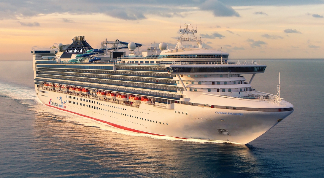
The images shown are for illustration purposes only and may not be an exact representation of what you find on the ship.
8 nights aboard the Carnival Encounter | |||
Drinks Packages available | |||
Evening entertainment & Broadway style shows | |||
Serenity adults only retreat (extra charges apply) | |||
Speciality Restaurants (charges may apply) | |||
24-hour room service | |||
24-hour Pizzeria | |||
Port Taxes and Fees | |||
![]() | ABTA and ATOL Protection* |
Date 17th Oct 2025 |
Nts 8 |
Interior £510pp |
Oceanview £578pp |
Balcony £763pp |
Suite ![]() |
Date 17th Oct 2025 |
Nts 8 |
Interior £510pp |
Oceanview £578pp |
Balcony £763pp |
Suite ![]() |
Interior staterooms from | £510pp | ||
4C | Interior | £528pp | |
4D | Interior | £531pp | |
4E | Interior | £541pp | |
4F | Interior | £543pp | |
4G | Interior | £547pp | |
IS | Interior | £510pp | |
Oceanview staterooms from | £578pp | ||
5A | Ocean View | £588pp | |
OV | Ocean View | £578pp | |
Balcony staterooms from | £763pp | ||
8A | Balcony | £773pp | |
8B | Balcony | £776pp | |
8C | Balcony | £779pp | |
8D | Balcony | £789pp | |
BL | Balcony | £763pp | |
Interior | Oceanview | Balcony | Suite | |
(All prices are £GBP per person) | ||||
Fri 19th Dec 202519 Dec 25 | 956 | 1,068 | 1,340 | 2,068 |
Sat 28th Nov 202628 Nov 26 | 492 | 540 | 710 | 840 |
Fusion Cruises when selling travel arrangements is a trading name of The Midcounties Co-operative Ltd. Fusion Cruises is an Accredited Body Member of Midcounties Co-operative Travel Consortium. (ABTA:P6652, ATOL:6053).
Book with Confidence. We are a Member of ABTA which means you have the benefit of ABTA’s assistance and Code of Conduct.
Some of the flights and flight-inclusive holidays on this website are financially protected by the ATOL scheme but ATOL protection does not apply to all holiday and travel services offered on this website. This website will provide you with information on the protection that applies in the case of each holiday and travel service offered before you make your booking. If you do not receive an ATOL Certificate then the booking will not be ATOL protected. If you do receive an ATOL Certificate but all parts of your trip are not listed on it, those parts will not be ATOL protected. Please see our booking conditions for information, or for more information about financial protection and the ATOL Certificate go to: www.caa.co.uk