| | | | | Arrive | Depart |
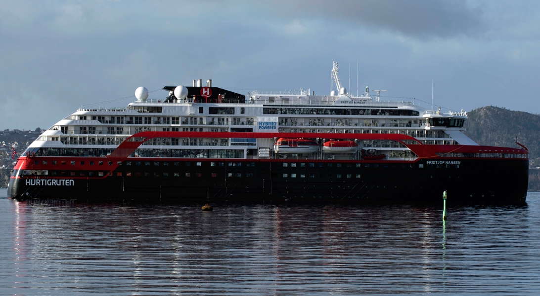
| 11th11 | AugAug | 202727 | Nuuk (Godthaab), Greenland, embark on the MS Fridtjof Nansen | | 22:00 |
Nuuk, meaning “the cape”, was Greenland’s first town (1728). Started as a fort and later mission and trading post some 240 kilometers south of the Arctic Circle, it is the current capital. Almost 30% of Greenland’s population lives in the town. Not only does Nuuk have great natural beauty in its vicinity, but there are Inuit ruins, Hans Egede’s home, the parliament, and the Church of our Saviour as well. The Greenlandic National Museum has an outstanding collection of Greenlandic traditional dresses, as well as the famous Qilakitsoq mummies. The Katuaq Cultural Center’s building was inspired by the undulating Northern Lights and can house 10% of Nuuk’s inhabitants. Flight from New York to Nuuk Nuuk is Greenland’s colourful and compact capital. With a population of fewer than 20,000, it’s a striking mix of old and modern buildings. If you’re more a fan of the former, head down to the old part of town by the waterfront, where you’ll find Nuuk Cathedral and the statue of Hans Egede standing on a hill. In the water below, you’ll see the beautiful Mother of the Sea statue. Your expedition ship awaits you in the harbour. After being welcomed aboard and collecting your complimentary expedition jacket, it's time to settle into your cabin and enjoy your first dinner aboard. |
| 12th12 | AugAug | 202727 | Evighedsfjorden, Greenland | 13:00 | 20:00 |
Discover the magical beauty of West Greenland The first chapter of our journey encompasses the majestic coast of West Greenland. Over the next three days you’ll experience some of the most iconic sites in all of Greenland. Our objectives include: Evighedsfjord As we head north, we plan to offer an exploration day in the magical and pristine Evighedsfjord near Maniitsoq. We'll determine on the day what adventures we can take part in. The 'Fjord of Eternity' is fed by an ice cap that calves huge icebergs into its 2,300 ft deep waters. It's surrounded by mist-cloaked mountains with beautiful white ridges, punctuated by crystal blue ice caves. Sisimiut Sisimiut is Greenland’s second city, situated in a spectacular location just above the Arctic Circle. This area has history spanning more than 4,500 years, and old traditions are alive and well. Learn more about ancient Saqqaq artifacts in the local museum or stretch your legs on a hike. If you're looking for a special souvenir, pick up a scarf, hat or mittens made of qiviut, the inner wool of the musk ox that’s said to be 10 times warmer than sheep’s wool. Ilulissat Nestled at the edge of the magnificent Ilulissat Icefjord, a UNESCO World Heritage Site, is Ilulissat. Here you’ll find an ever-changing gallery of passing icebergs set against a backdrop of colourful houses. In town you can visit a multitude of shops selling local crafts, and on the outskirts walking trails take you along the epic icefjord. |
| 13th13 | AugAug | 202727 | Sisimiut (Holsteinsborg), Greenland | 06:00 | 18:00 |
Located just north of the Arctic Circle, Sisimiut is the northernmost town in Greenland where the port remains free of ice in the winter. Yet it is also the southernmost town where there is enough snow and ice to drive a dogsled in winter and spring. In Sisimiut, travelling by sled has been the primary means of winter transportation for centuries. In fact, the area has been inhabited for approximately 4,500 years. Modern Sisimiut is the largest business center in the north of Greenland, and is one of the fastest growing Greenlandic cities. Commercial fishing is the lead economy in the town‘s thriving industrial base. |
| 14th14 | AugAug | 202727 | Ilulissat (Jakobshavn), Greenland | 10:00 | 18:00 |
Known as the birthplace of icebergs, the Ilulissat Icefjord produces nearly 20 million tons of ice each day. In fact, the word Ilulissat means “icebergs” in the Kalaallisut language. The town of Ilulissat is known for its long periods of calm and settled weather, but the climate tends to be cold due to its proximity to the fjord. Approximately 4,500 people live in Ilulissat, the third-largest town in Greenland after Nuuk and Sisimiut. Some people here estimate that there are nearly as many sled dogs as human beings living in the town that also boasts a local history museum located in the former home of Greenlandic folk hero and famed polar explorer Knud Rasmussen. |
| 15th15 | AugAug | 202727 | Baffin Bay, Nunavut, Canada | | |
Watch for wildlife and get involved in Citizen Science Leaving Greenland behind, we spend two days at sea crossing Baffin Bay towards Nunavut. Gain authentic insight into Inuit culture and heritage with our onboard Cultural Ambassadors. Their stories reveal the Inuit people’s profound connection to the land, shaped by generations of tradition and resilience. Meanwhile, your Expedition Team leads lectures on topics such as Arctic wildlife and the history of exploration in the region. You can also take part in Citizen Science, such as the GLOBE Program, where you’ll observe clouds to help scientists study our climate. |
| 16th16 | AugAug | 202727 | Baffin Bay, Nunavut, Canada | | |
| 17th17 | AugAug | 202727 | Pond Inlet, Nunavut, Canada | 08:00 | 16:00 |
Located in northern Baffin Island, Pond Inlet is a small, predo¬minantly Inuit community, with a population of roughly 1,500 inhabitants. In 1818, the British explorer John Ross named a bay in the vicinity after the English astronomer John Pond. Today Pond Inlet is considered one of Canada's "jewels of the North" thanks to several picturesque glaciers and mountain ranges nearby. Many archaeological sites of ancient Dorset and Thule peoples can be found near Pond Inlet. The Inuit hunted caribou, ringed and harp seals, fish, polar bears, walrus, narwhals, geese, ptarmigans and Arctic hares, long before European and American whalers came here to harvest bowhead whales. Pond Inlet is also known as a major center of Inuit art, especially the printmaking and stone carving that are featured in the town’s art galleries. Entering into the Northwest Passage Following our crossing of Baffin Bay, we find ourselves in the Eastern Canadian Arctic. The main waterway of this area is Lancaster Sound (Tallurutiup Imanga), the eastern gates to the Northwest Passage. This chapter of our exploration is likely to be action-packed, with excursions planned on each of the four days we hope to spend in and around this area. Remember, all our excursion plans are weather and ice dependent but, conditions permitting, our days will be filled with excitement and discovery. Excursion stops and local highlights we hope to share with you include: Pond Inlet (Mittimatalik) Dundas Harbour Croker Bay Beechey Island (Iluvilik) Prince Leopold Island (Appait) Fort Ross
|
| 18th18 | AugAug | 202727 | Dundas Harbour, Devon Island, Nunavut, Canada | 08:00 | 13:00 |
Dundas Harbour is located in the southeast of Devon Island, Canada’s 6th largest island. It is a forlorn but starkly beautiful spot. The island was first sighted by Europeans in 1616 by the English explorers Robert Bylot and William Baffin. But it did not appear on maps until after explorer William Edward Parry’s exploration in the 1820’s. Parry named it after Devon, England. In the local Inuktitut language, the place is called Talluruti, which translates as “a woman’s chin with tattoos on it.” This refers to the deep crevasses and streaks on Devon Island, which from a distance resemble traditional facial tattoos. On land there are remains of a Thule settlement dating back to 1000 A.D., including tent rings, middens and a gravesite. There are also much more recent remains a Royal Canadian Mounted Police outpost. The first post was established in 1924 to monitor and control illegal activities, such as foreign whaling, in the eastern entrance to the Northwest Passage. But conditions were so isolated and severe that the post was abandoned in 1933. It was reopened in 1945, but again closed, this time permanently, in 1951. Today, Devon Island is the largest uninhabited island in the world. |
| 18th18 | AugAug | 202727 | Croker Bay, Nunavut, Canada | 16:00 | 20:00 |
| 19th19 | AugAug | 202727 | Beechey Island, Nunavut, Canada | 10:30 | 18:00 |
Beechey Island is a small island off the southwest coast of Devon Island, separated by a narrow waterway called the Barrow Strait. Captain William Edward Parry was the first European to visit the island in 1819. His lieutenant, Frederick William Beechey, named the island after his father, the artist William Beechey (1753–1839). Beechey Island played a significant role in the history of Arctic Exploration. During the winter of 1845-46, Sir John Franklin and his men camped on the island as part of their ill-fated quest to find the Northwest Passage. Mummified remains of three of Franklin’s crew were discovered, giving a better understanding of what happened before the disappearance of the expedition. In 1850 Edward Belcher used the island as a base while surveying the area. Later, in 1903, Norwegian explorer Roald Amundsen stopped at the island at the beginning of his successful voyage in search for the Northwest Passage. Subsequently, Beechey Island has been declared a "Territorial Historic Site" since 1975 by the Northwest Territories government |
| 19th19 | AugAug | 202727 | Prince Leopold Island, Nunavut, Canada | 22:00 | 23:00 |
| 20th20 | AugAug | 202727 | Fort Ross, Nunavut, Canada | 10:00 | 08:00 |
| 21st21 | AugAug | 202727 | Coningham Bay, Nunavut, Canada | 17:00 | 21:00 |
Navigate the dividing line between East and West The ‘Rubicon’ of the Canadian Arctic, dividing East from West, is the infamous Bellot Strait. This narrow body of water separates the northernmost part of mainland North America from Somerset Island, one of the largest islands in the Canadian Arctic archipelago. Bellot Strait is approximately 15 nautical miles long and just over half a mile wide at its narrowest point. Our ability to navigate this passage will be determined by ice and weather conditions. |
| 22nd22 | AugAug | 202727 | At Sea | | |
| 23rd23 | AugAug | 202727 | Gjoa Haven, Nunavut, Canada | 07:00 | 15:00 |
| 24th24 | AugAug | 202727 | At Sea | | |
| 25th25 | AugAug | 202727 | Cambridge Bay, Nunavut, Canada | 07:00 | 15:00 |
| 26th26 | AugAug | 202727 | At Sea | | |
| 27th27 | AugAug | 202727 | Ulukhaktok, Northwest Territories, Canada | 08:00 | 16:00 |
| 28th28 | AugAug | 202727 | At Sea | | |
| 29th29 | AugAug | 202727 | Herschel Island, Yukon, Canada | 16:00 | 23:00 |
| 30th30 | AugAug | 202727 | At Sea | | |
| 31st31 | AugAug | 202727 | At Sea | | |
| 1st01 | SepSep | 202727 | At Sea | | |
| 2nd02 | SepSep | 202727 | At Sea | | |
| 3rd03 | SepSep | 202727 | Nome, Alaska, United States | 06:00 | |
Nome is located on the edge of the Bering Sea, on the southwest side of the Seward Peninsula. Unlike other towns which are named for explorers, heroes or politicians, Nome was named as a result of a 50 year-old spelling error. In the 1850's an officer on a British ship off the coast of Alaska noted on a manuscript map that a nearby prominent point was not identified. He wrote "? Name" next to the point. When the map was recopied, another draftsman thought that the “?” was a C and that the “a” in "Name" was an o, and thus a map-maker in the British Admiralty christened "Cape Nome." The area has an amazing history dating back 10,000 years of Inupiaq Eskimo use for subsistence living. Modern history started in 1898 when "Three Lucky Swedes”, Jafet Lindberg, Erik Lindblom and John Brynteson, discovered gold in Anvil Creek…the rush was on! In 1899 the population of Nome swelled from a handful to 28,000. Today the population is just over 3,500. Much of Nome's gold rush architecture remains. Learn about Alaska’s ‘golden’ past Prospectors first came to Nome in 1898, and people still hunt for gold here today. You'll see evidence of the Gold Rush era all around, including abandoned dredges, turn-of-the century steam engines and old railroad tracks, lending the town a unique and intriguing atmosphere. Wyatt Earp, the famous sheriff, opened a saloon here. Nome was also the end point of three of Roald Amundsen's great polar expeditions. From here you’ll take a flight to Seattle for an overnight stay. |
| 4th04 | SepSep | 202727 | Seattle, Washington, United States, disembark the MS Fridtjof Nansen | | |
Seattle is a scenic seaport city in western Washington, situated on an isthmus between Puget Sound to the west and Lake Washington to the east. It is the largest city in Washington. Five pioneer families from Illinois first settled the area in 1851, and named the town after a friendly Suquamish Indian chief. It was incorporated as a city in 1869, and grew quickly after the Great Northern Railway arrived in 1893, especially during the Alaska Gold Rush of 1897. When the Panama Canal opened in 1914, Seattle became a major Pacific port of entry, and today it is the region's commercial and transportation hub and the centre of manufacturing, trade, and finance, with an estimated 684,451 residents as of 2015. End your adventure in the Emerald City Waking up in your hotel in Seattle marks the end of your adventure through the Arctic labyrinth. After breakfast, and if you have time before your onward journey, why not explore the Emerald City and see what it has to offer. Why not take a stroll through the nine-acre Olympic Sculpture Park for incredible views of Puget Sound and the surrounding mountains, admiring the work of renowned artists as you go. For a feast of the senses, visit the famous Pike Place Market. Operating for over a century, this lively farmer’s market boasts everything from buskers and bars to salmon-throwing fishmongers. |