This site uses cookies as defined in our Cookie Policy, by continuing to use this site you agree to their use.
Continue

| Arrive | Depart | ||||||
| 6th06 | JanJan | 202626 | Fort Lauderdale, Florida, United States, embark on the Silver Dawn | 18:00 | |||
Like many southeast Florida neighbors, Fort Lauderdale has long been revitalizing. In a state where gaudy tourist zones often stand aloof from workaday downtowns, Fort Lauderdale exhibits consistency at both ends of the 2-mile Las Olas corridor. The sparkling look results from upgrades both downtown and on the beachfront. Matching the downtown's innovative arts district, cafés, and boutiques is an equally inventive beach area, with hotels, cafés, and shops facing an undeveloped shoreline, and new resort-style hotels replacing faded icons of yesteryear. Despite wariness of pretentious overdevelopment, city leaders have allowed a striking number of glittering high-rises. Nostalgic locals and frequent visitors fret over the diminishing vision of sailboats bobbing in waters near downtown; however, Fort Lauderdale remains the yachting capital of the world, and the water toys don’t seem to be going anywhere. Miles of sandy beaches, lively outdoor events, and a charming web of waterways help to make Fort Lauderdale a relaxed, vacation capital of Florida. The excitement is palpable, as cruise ships and gleaming yachts gather in the harbour ahead of adventures and luxury journeys across the waves. Soak up the relaxed atmosphere in the canal-laced 'Venice of America,' as you enjoy big label shopping on Las Olas Boulevard - or visit fancy restaurants and bustling art galleries. For a wilder experience, the swampy wetlands of the Everglades sprawl away nearby. Fort Lauderdale Beach is a lively stretch of sand, bordered by palm trees, and sprinkled with crowds enjoying the Sunshine State's generous weather. The charming promenade of red-brick tiles extends right along the beach's length and rumbles with passing rollerbladers and cyclists. Flick across the waves while paragliding, or relax with a coffee or a margarita in a beachfront bar, as volleyball games play out in front of you. For a quieter beach option, Olas Beach lies a little down the coast towards Port Everglades, and has extra space to spread out and tan on acres of smooth white sand. Spot the backs of alligators waiting patiently, and the toothy grins of crocodiles patrolling the murky waters of the Everglades – the USA's biggest tropical wetlands. A haven of extraordinary wildlife, birds wade through its swamps, and black bears and panthers roam its wilds. Take to a plane to appreciate the full scale of the national park or purr along exploring its waterways in a fan powered boat. | |||||||
| 7th07 | JanJan | 202626 | At Sea | ||||
| 8th08 | JanJan | 202626 | Cozumel, Mexico | 08:00 | 23:00 | ||
Cozumel, a Caribbean gem off Mexico’s Yucatán Peninsula, is celebrated for its crystal-clear waters, vibrant coral reefs, and rich Mayan history. A haven for divers and snorkelers, the island is home to the Mesoamerican Reef, teeming with colorful marine life. Beyond the sea, explore ancient ruins like San Gervasio, enjoy local charm in San Miguel’s markets, or relax on pristine beaches. Eco-parks like Punta Sur offer lush landscapes and wildlife encounters. Blending natural beauty, cultural heritage, and adventure, Cozumel promises a tropical escape that captivates every traveler. Dive into the exuberant colourful world of Cozumel - a Mexican island of exceptional scuba diving snorkelling and dazzling beaches. Abundant underwater ecosystems swirl among reefs of black coral - attracting experts and beginners alike to the azure waters of this island. Waiting across the Carribean waters from Playa Del Carmen and a world away from its lively resorts Cozumel is an idyllic land of gently curving palm trees and tropical shores. Playa Palancar occupies the western coast with velvety powder and balmy Caribbean seas. Relax with just the notes of the washing sea and whispering palm trees accompanying you during splashes through the shallow waves or tanning sessions on the soft sand. Playa El Cielo - or the appropriately named Heaven Beach - is home to a divine constellation of starfish resting on the seabed below its glass-clear waters. Stingrays and sea turtles also swirl in the waters as you snorkel through some of the island's most vibrant and diverse displays of marine life. Beach bars serve up spicy Mexican fare with a seaside twist - like delicious prawn fajitas fish tacos and lime-squeezed ceviches. The crumbling San Gervasio ruins meanwhile offer cultural intrigue and a fascinating insight into the remarkable ancient Mayan civilisation. Despite the presence of majestic ruins from antiquity it's the giant iguanas soaking up the sun in clearings who often unwittingly steal the show. | |||||||
| 9th09 | JanJan | 202626 | At Sea | ||||
| 10th10 | JanJan | 202626 | At Sea | ||||
| 11th11 | JanJan | 202626 | Puerto Limón, Costa Rica | ||||
Christopher Columbus became Costa Rica's first tourist when he landed on this stretch of coast in 1502 during his fourth and final voyage to the New World. Expecting to find vast mineral wealth, he named the region Costa Rica ("rich coast"). Imagine the Spaniards' surprise eventually to find there was none. Save for a brief skirmish some six decades ago, the country did prove itself rich in a long tradition of peace and democracy. No other country in Latin America can make that claim. Costa Rica is also abundantly rich in natural beauty, managing to pack beaches, volcanoes, rain forests, and diverse animal life into an area the size of Vermont and New Hampshire combined. It has successfully parlayed those qualities into its role as one the world's great ecotourism destinations. A day visit is short, but time enough for a quick sample. Christopher Columbus became Costa Rica's first tourist when he landed on this stretch of coast in 1502 during his fourth and final voyage to the New World. Expecting to find vast mineral wealth, he named the region Costa Rica ("rich coast"). Imagine the Spaniards' surprise eventually to find there was none. Save for a brief skirmish some six decades ago, the country did prove itself rich in a long tradition of peace and democracy. No other country in Latin America can make that claim. Costa Rica is also abundantly rich in natural beauty, managing to pack beaches, volcanoes, rain forests, and diverse animal life into an area the size of Vermont and New Hampshire combined. It has successfully parlayed those qualities into its role as one the world's great ecotourism destinations. A day visit is short, but time enough for a quick sample. | |||||||
| 12th12 | JanJan | 202626 | Colón, Panama | 09:00 | 23:00 | ||
The provincial capital of Colón, beside the canal's Atlantic entrance, is named for the Spanish-language surname of Christopher Columbus, though the Americans called it Aspinwall in the 19th century.. The city was founded in 1850 by Americans working on the Panama railroad and named Aspinwall for one of the railway engineers. Following completion in 1855, Colon gained in importance, which was furthered by the plans for an isthmian canal. During the time of the French canal attempt, a fire in 1885 burned the city nearly to the ground and left thousands of people homeless. Colon was rebuilt in the architectural style then popular in France. Buildings from that era plus the ones constructed by Americans between 1904 and 1914 are still in use today, although the majority is on the verge of collapse. In addition to its importance as a port, Colon boasts the world’s second largest duty-free zone, known as Zona Libre, which is contained in a huge fortress like, walled-off area with giant international stores. However, most of the merchandise is sold in bulk to commercial businesses throughout the country. Colon welcomes you to one of humanity's most extraordinary engineering endeavours the Panama Canal. This extraordinary waterway connects two of the world’s great oceans and on opening saved ships from an epic and treacherous 8 000 mile voyage around Cape Horn. Take an old world voyage on the regally romantic Panama Railway Canal which preceded the canal and was constructed at extraordinary human cost to traverse Panama’s narrow land. A side trip to the UNESCO World Heritage Site Portobelo is also a must. With its reef rock fortifications built by the Spanish in the 17th century these jagged jaws of coral were carved to cut approaching pirates and conquistadors to shreds. It shares its World Heritage Site designation with nearby Fort San Lorenzo which perches on an emerald-green cliff casting its gaze over the harbour below. Back in Colon after staring in awe at the grand clanging Gatun Locks and splurging on a case of duty-free rum and trinkets from the Colon Free Trade Zone - a trip to the beach will soothe city-worn souls. Playa La Angosta is a rabble of raucous beach-going fun where the blue waters swirl with bright banana boats and fleeting canoes. Relax on the sand among sizzling yuca fritters and families clamouring in the shade of cabanas. On the Caribbean side Playa Chiquita is accessible only by boat but rewards with warm gin-clear waters backed by thick rainforest. | |||||||
| 13th13 | JanJan | 202626 | At Sea | 05:30 | 18:30 | ||
| Enter the mighty Panama Canal, one of history’s most ambitious and spectacular stretches of waterway. Connecting the Atlantic and Pacific oceans, and slicing through the heart of a continent, the canal is a staggering engineering triumph, eliminating the need to traverse the treacherous waters of South America and Cape Horn. Sail one of the world’s great canals to appreciate the true scale of this achievement, as your ship manoeuvres between its vast, gushing locks and huge lakes. The French began construction in 1881, but the costly project was left abandoned and unfinished until the United States finally completed the work in 1914. Following the path of the Panama Railway of 1855, locks raise ships large and small 26 metres up above sea level to the canal’s elevated channel. New locks have recently been added, which allow the canal to accommodate ever bigger ships. Leaving the confinement of the locks, you will enter the canal’s channel, to sail through Panama’s core. Wide lakes are linked by painstakingly chiselled wedges of canal, which slice through the lush scenery. Look out for the Culebra Cut section, the most challenging stretch of the entire route to construct. The Bridge of the Americas is a vast arched landmark, which sweeps across the Pacific Entrance and was completed in 1962. It’s one of several huge bridges that you will sail below on the 51-mile journey, including the much newer Centennial Bridge, and the Atlantic Bridge, which spans the entrance close to Colon. | |||||||
| 14th14 | JanJan | 202626 | At Sea | ||||
| 15th15 | JanJan | 202626 | Manta, Ecuador | 08:00 | 19:00 | ||
| As home to Ecuador’s second-largest seaport, Manta is a one of the most important economic cities in the country. So, far from rustic shores and a sleepy village, visitors to Manta can expect a modern urban hub, complete with vast beach, high rises, city slickers and lots and lots of fish. This is the city that has a giant tuna statue welcoming its visitors, so it is no surprise that seafood is high on everybody’s list of important things. What was once a small fishing village has today grown into a mighty industry and ultra-fresh seafood – mostly tuna – takes pride of place. Thus, no trip to Manta is complete without sampling at least one of the local dishes. Foodies will salivate at the opportunity of tasting not only amazing tuna ceviche but also exquisitely prepared squid, octopus, lobster and inspired South American style tapas. If tasting the city’s legacy isn’t enough for you, then the Archaeological Museum of the Central Bank of Manta boasts an excellent collection of ceramics of the Manteño-Huancavilca culture that flourished here between 800 and 1550 A.D. Manta’s seafood, beaches and boutiques might be enough for some people, but it is worth noting that picturesque Montechristi is only about 20 minutes away. Jump on a colourful (and colourfully authentic) Chivas bus for the short ride to the home of the Panama hat – which does not originate anywhere near Panama! The enchanting village has retained much of its faded Spanish elegance with its milliners by far its star attraction. | |||||||
| 16th16 | JanJan | 202626 | At Sea | ||||
| 17th17 | JanJan | 202626 | At Sea | ||||
| 18th18 | JanJan | 202626 | Callao, Peru | ||||
When people discuss great South American cities, Lima is often overlooked. But Peru's capital can hold its own against its neighbors. It has an oceanfront setting, colonial-era splendor, sophisticated dining, and nonstop nightlife.It's true that the city—clogged with traffic and choked with fumes—doesn't make a good first impression, especially since the airport is in an industrial neighborhood. But wander around the regal edifices surrounding the Plaza de Armas, among the gnarled olive trees of San Isidro's Parque El Olivar, or along the winding lanes in the coastal community of Barranco, and you'll find yourself charmed.In 1535 Francisco Pizarro found the perfect place for the capital of Spain's colonial empire. On a natural port, the so-called Ciudad de los Reyes (City of Kings) allowed Spain to ship home all the gold the conquistador plundered from the Inca. Lima served as the capital of Spain's South American empire for 300 years, and it's safe to say that no other colonial city enjoyed such power and prestige during this period.When Peru declared its independence from Spain in 1821, the declaration was read in the square that Pizarro had so carefully designed. Many of the colonial-era buildings around the Plaza de Armas are standing today. Walk a few blocks in any direction for churches and elegant houses that reveal just how wealthy this city once was. But the poor state of most buildings attests to the fact that the country's wealthy families have moved to neighborhoods to the south over the past century.The walls that surrounded the city were demolished in 1870, making way for unprecedented growth. A former hacienda became the graceful residential neighborhood of San Isidro. In the early 1920s the construction of tree-lined Avenida Arequipa heralded the development of neighborhoods such as bustling Miraflores and bohemian Barranco.Almost a third of the country's population of 29 million lives in the metropolitan area, many of them in relatively poor conos: newer neighborhoods on the outskirts of the city. Most residents of those neighborhoods moved there from mountain villages during the political violence and poverty that marked the 1980s and ’90s, when crime increased dramatically. During the past decade the country has enjoyed peace and steady economic growth, which have been accompanied by many improvements and refurbishment in the city. Residents who used to steer clear of the historic center now stroll along its streets. And many travelers who once would have avoided the city altogether now plan to spend a day here and end up staying two or three. Splashing colour and culture into the arid Peruvian landscape, Lima is a city bedecked with grand colonial splendour. Founded in 1535, this sprawling capital enjoys a breezy oceanfront location and forms one of the world's largest desert cities. A place of sharp contrasts, almost 10 million people are packed into the city, occupying vastly different living conditions. Visit for an unfiltered experience of this richly layered place of ancient history, colonial relics and dazzling flavours. Rising from the misty blanket of the garua - a persistent fog that cloaks Lima during winter - you'll find one of South America's most culturally vibrant cities. The former capital of the Spanish colonists - head to Plaza de Armas to immerse yourself in the heart of the old city. The Basilica Cathedral of Lima watches over Plaza Mayor - listen out for the stomps of boots outside, as the pomp and ceremony of the Changing of the Guards draws crowds to the Government Palace. The history of this area runs much deeper, however, and pre-Colombian cities and temples emerge from the dusty earth nearby. Grand museums showcase unearthed treasures from the extraordinary civilisations who built vast mud adobe cities across Peru's coastline, and incredible settlements in the country's valleys and mountains. The Barranco district is Lima's artsy area, and you can walk from modern art galleries to see the local muse, the Bridge of Sighs. This wooden bridge is an artist's favourite, and one of the city's most romantic spots. Afterwards, sample some of Lima's cuisine, and the zingy flavours of spicy, lime-marinated fish ceviche. So revered in these parts, ceviche even has its own national day on June 28th. Sipping a Pisco Sour is the perfect way to round off your visit to this engrossing, multi-layered city. | |||||||
| 19th19 | JanJan | 202626 | Callao, Peru | ||||
When people discuss great South American cities, Lima is often overlooked. But Peru's capital can hold its own against its neighbors. It has an oceanfront setting, colonial-era splendor, sophisticated dining, and nonstop nightlife.It's true that the city—clogged with traffic and choked with fumes—doesn't make a good first impression, especially since the airport is in an industrial neighborhood. But wander around the regal edifices surrounding the Plaza de Armas, among the gnarled olive trees of San Isidro's Parque El Olivar, or along the winding lanes in the coastal community of Barranco, and you'll find yourself charmed.In 1535 Francisco Pizarro found the perfect place for the capital of Spain's colonial empire. On a natural port, the so-called Ciudad de los Reyes (City of Kings) allowed Spain to ship home all the gold the conquistador plundered from the Inca. Lima served as the capital of Spain's South American empire for 300 years, and it's safe to say that no other colonial city enjoyed such power and prestige during this period.When Peru declared its independence from Spain in 1821, the declaration was read in the square that Pizarro had so carefully designed. Many of the colonial-era buildings around the Plaza de Armas are standing today. Walk a few blocks in any direction for churches and elegant houses that reveal just how wealthy this city once was. But the poor state of most buildings attests to the fact that the country's wealthy families have moved to neighborhoods to the south over the past century.The walls that surrounded the city were demolished in 1870, making way for unprecedented growth. A former hacienda became the graceful residential neighborhood of San Isidro. In the early 1920s the construction of tree-lined Avenida Arequipa heralded the development of neighborhoods such as bustling Miraflores and bohemian Barranco.Almost a third of the country's population of 29 million lives in the metropolitan area, many of them in relatively poor conos: newer neighborhoods on the outskirts of the city. Most residents of those neighborhoods moved there from mountain villages during the political violence and poverty that marked the 1980s and ’90s, when crime increased dramatically. During the past decade the country has enjoyed peace and steady economic growth, which have been accompanied by many improvements and refurbishment in the city. Residents who used to steer clear of the historic center now stroll along its streets. And many travelers who once would have avoided the city altogether now plan to spend a day here and end up staying two or three. Splashing colour and culture into the arid Peruvian landscape, Lima is a city bedecked with grand colonial splendour. Founded in 1535, this sprawling capital enjoys a breezy oceanfront location and forms one of the world's largest desert cities. A place of sharp contrasts, almost 10 million people are packed into the city, occupying vastly different living conditions. Visit for an unfiltered experience of this richly layered place of ancient history, colonial relics and dazzling flavours. Rising from the misty blanket of the garua - a persistent fog that cloaks Lima during winter - you'll find one of South America's most culturally vibrant cities. The former capital of the Spanish colonists - head to Plaza de Armas to immerse yourself in the heart of the old city. The Basilica Cathedral of Lima watches over Plaza Mayor - listen out for the stomps of boots outside, as the pomp and ceremony of the Changing of the Guards draws crowds to the Government Palace. The history of this area runs much deeper, however, and pre-Colombian cities and temples emerge from the dusty earth nearby. Grand museums showcase unearthed treasures from the extraordinary civilisations who built vast mud adobe cities across Peru's coastline, and incredible settlements in the country's valleys and mountains. The Barranco district is Lima's artsy area, and you can walk from modern art galleries to see the local muse, the Bridge of Sighs. This wooden bridge is an artist's favourite, and one of the city's most romantic spots. Afterwards, sample some of Lima's cuisine, and the zingy flavours of spicy, lime-marinated fish ceviche. So revered in these parts, ceviche even has its own national day on June 28th. Sipping a Pisco Sour is the perfect way to round off your visit to this engrossing, multi-layered city. | |||||||
| 19th19 | JanJan | 202626 | Callao, Peru | 23:00 | |||
When people discuss great South American cities, Lima is often overlooked. But Peru's capital can hold its own against its neighbors. It has an oceanfront setting, colonial-era splendor, sophisticated dining, and nonstop nightlife.It's true that the city—clogged with traffic and choked with fumes—doesn't make a good first impression, especially since the airport is in an industrial neighborhood. But wander around the regal edifices surrounding the Plaza de Armas, among the gnarled olive trees of San Isidro's Parque El Olivar, or along the winding lanes in the coastal community of Barranco, and you'll find yourself charmed.In 1535 Francisco Pizarro found the perfect place for the capital of Spain's colonial empire. On a natural port, the so-called Ciudad de los Reyes (City of Kings) allowed Spain to ship home all the gold the conquistador plundered from the Inca. Lima served as the capital of Spain's South American empire for 300 years, and it's safe to say that no other colonial city enjoyed such power and prestige during this period.When Peru declared its independence from Spain in 1821, the declaration was read in the square that Pizarro had so carefully designed. Many of the colonial-era buildings around the Plaza de Armas are standing today. Walk a few blocks in any direction for churches and elegant houses that reveal just how wealthy this city once was. But the poor state of most buildings attests to the fact that the country's wealthy families have moved to neighborhoods to the south over the past century.The walls that surrounded the city were demolished in 1870, making way for unprecedented growth. A former hacienda became the graceful residential neighborhood of San Isidro. In the early 1920s the construction of tree-lined Avenida Arequipa heralded the development of neighborhoods such as bustling Miraflores and bohemian Barranco.Almost a third of the country's population of 29 million lives in the metropolitan area, many of them in relatively poor conos: newer neighborhoods on the outskirts of the city. Most residents of those neighborhoods moved there from mountain villages during the political violence and poverty that marked the 1980s and ’90s, when crime increased dramatically. During the past decade the country has enjoyed peace and steady economic growth, which have been accompanied by many improvements and refurbishment in the city. Residents who used to steer clear of the historic center now stroll along its streets. And many travelers who once would have avoided the city altogether now plan to spend a day here and end up staying two or three. Splashing colour and culture into the arid Peruvian landscape, Lima is a city bedecked with grand colonial splendour. Founded in 1535, this sprawling capital enjoys a breezy oceanfront location and forms one of the world's largest desert cities. A place of sharp contrasts, almost 10 million people are packed into the city, occupying vastly different living conditions. Visit for an unfiltered experience of this richly layered place of ancient history, colonial relics and dazzling flavours. Rising from the misty blanket of the garua - a persistent fog that cloaks Lima during winter - you'll find one of South America's most culturally vibrant cities. The former capital of the Spanish colonists - head to Plaza de Armas to immerse yourself in the heart of the old city. The Basilica Cathedral of Lima watches over Plaza Mayor - listen out for the stomps of boots outside, as the pomp and ceremony of the Changing of the Guards draws crowds to the Government Palace. The history of this area runs much deeper, however, and pre-Colombian cities and temples emerge from the dusty earth nearby. Grand museums showcase unearthed treasures from the extraordinary civilisations who built vast mud adobe cities across Peru's coastline, and incredible settlements in the country's valleys and mountains. The Barranco district is Lima's artsy area, and you can walk from modern art galleries to see the local muse, the Bridge of Sighs. This wooden bridge is an artist's favourite, and one of the city's most romantic spots. Afterwards, sample some of Lima's cuisine, and the zingy flavours of spicy, lime-marinated fish ceviche. So revered in these parts, ceviche even has its own national day on June 28th. Sipping a Pisco Sour is the perfect way to round off your visit to this engrossing, multi-layered city. | |||||||
| 20th20 | JanJan | 202626 | At Sea | ||||
| 21st21 | JanJan | 202626 | At Sea | ||||
| 22nd22 | JanJan | 202626 | At Sea | ||||
| 23rd23 | JanJan | 202626 | At Sea | ||||
| 24th24 | JanJan | 202626 | At Sea | ||||
| 25th25 | JanJan | 202626 | Hangaroa, Easter Island, Chile | ||||
Discovered (by the Western world) on Easter Sunday, 1722, Easter Island is a UNESCO World Heritage Site and one of the most isolated places on the face of the Earth, some 2,300 miles from the Chilean mainland. Although more Polynesian than South American in character, the 64-square mile island was annexed by Chile in 1888, and is now famous as the world’s largest ‘open air museum’ on account of the Moai, or human-like stone statues, that can be found on the island. The Moai remain very much a mystery, which archaeologists are still trying to unlock by interpreting an ancient language of the Rapa Nui, which is the key to understanding this culture, and is written on the so called ‘rongo rongo tablets’. The island owes its origin to three volcanoes which erupted some three million years ago: Poike, Rano Kau and Maunga Terevaka. It is not known when or how the island was first populated, but the most credible theory suggests that the Rapa Nui people came from other Pacific islands in the 4th century AD. In addition to the cultural and archaeological interest, there are the beautiful beaches, transparent waters, and coral reefs that might be expected of a Pacific Island. Easter Island, the easternmost settled island of Polynesia, received its European name in 1722 when the island was seen by a Dutch expedition under Roggeveen on Easter Sunday. The triangular-shaped island of 163 square kilometers is famous for the hundreds of statues known locally as moai. Rolling hills covered in grassland, eucalyptus forest and a rocky shore surround Hangaroa, the island’s only village on the southwestern coast. This is where Captain Cook landed in 1774, where missionaries built the first church and where ships find the best protection from winds and swells. Small beaches and transparent waters invite swimmers and snorkelers, but it is the cultural aspect which attracts visitors. Since 1935 the island has been a National Historic Monument and today 43.5% of the island is a national park administered by the Chilean National Forest Corporation and Mau Henua, a local community group. The island’s national park has been declared a UNESCO World Heritage Site in 1995. Found slightly more than 3,500 kilometers west of Chile, the island was annexed in 1888. Used as a sheep ranch for many decades, the island was opened in 1965 and an airstrip was built. The US Air Force set up a base to record the behavior of the earth's outer atmosphere and by 1987 NASA had the runway extended as an emergency runway for the space shuttle. This never happened, but tourism benefitted from this improvement and today the island receives more than 100,000 visitors a year. | |||||||
| 26th26 | JanJan | 202626 | Hangaroa, Easter Island, Chile | 17:00 | |||
Discovered (by the Western world) on Easter Sunday, 1722, Easter Island is a UNESCO World Heritage Site and one of the most isolated places on the face of the Earth, some 2,300 miles from the Chilean mainland. Although more Polynesian than South American in character, the 64-square mile island was annexed by Chile in 1888, and is now famous as the world’s largest ‘open air museum’ on account of the Moai, or human-like stone statues, that can be found on the island. The Moai remain very much a mystery, which archaeologists are still trying to unlock by interpreting an ancient language of the Rapa Nui, which is the key to understanding this culture, and is written on the so called ‘rongo rongo tablets’. The island owes its origin to three volcanoes which erupted some three million years ago: Poike, Rano Kau and Maunga Terevaka. It is not known when or how the island was first populated, but the most credible theory suggests that the Rapa Nui people came from other Pacific islands in the 4th century AD. In addition to the cultural and archaeological interest, there are the beautiful beaches, transparent waters, and coral reefs that might be expected of a Pacific Island. Easter Island, the easternmost settled island of Polynesia, received its European name in 1722 when the island was seen by a Dutch expedition under Roggeveen on Easter Sunday. The triangular-shaped island of 163 square kilometers is famous for the hundreds of statues known locally as moai. Rolling hills covered in grassland, eucalyptus forest and a rocky shore surround Hangaroa, the island’s only village on the southwestern coast. This is where Captain Cook landed in 1774, where missionaries built the first church and where ships find the best protection from winds and swells. Small beaches and transparent waters invite swimmers and snorkelers, but it is the cultural aspect which attracts visitors. Since 1935 the island has been a National Historic Monument and today 43.5% of the island is a national park administered by the Chilean National Forest Corporation and Mau Henua, a local community group. The island’s national park has been declared a UNESCO World Heritage Site in 1995. Found slightly more than 3,500 kilometers west of Chile, the island was annexed in 1888. Used as a sheep ranch for many decades, the island was opened in 1965 and an airstrip was built. The US Air Force set up a base to record the behavior of the earth's outer atmosphere and by 1987 NASA had the runway extended as an emergency runway for the space shuttle. This never happened, but tourism benefitted from this improvement and today the island receives more than 100,000 visitors a year. | |||||||
| 27th27 | JanJan | 202626 | At Sea | ||||
| 28th28 | JanJan | 202626 | At Sea | ||||
| 29th29 | JanJan | 202626 | At Sea | ||||
| 30th30 | JanJan | 202626 | At Sea | ||||
| 31st31 | JanJan | 202626 | At Sea | ||||
| 1st01 | FebFeb | 202626 | Nuku Hiva Island, French Polynesia | 09:00 | 22:00 | ||
| Think of French Polynesia and you are automatically transported to the white sands of Tahiti, the blue seas of Bora Bora or, at the very least, the iconic statues of Easter Island. Now, imagine a place that is home to that majestic trinity, but has no crowds and is full of island authenticity that is rare in these global times. You have just imagined Nuku Hiva. The island is the second largest after Tahiti in the archipelago, but is yet to be discovered by tourism. As part of the Marquesas Islands, Nuku Hiva is technically French, but don’t expect to find any blue and white striped shirts here! In fact, even though French is the “official” language of the island, a sing-song dialect of Tahitian mixed with Marquesan is more widely spoken. The younger generations also speak English. Undeniably, Nuku Hiva has been blessed by the Gods. With towering mountains, eight magnificent harbours, and one of the world's highest waterfalls, Nuku Hiva is rich with Mother Nature’s jewels. The island could lay claim to a great many claims to fame, such as its deep, unpolluted waters, its lush forests bursting with vitality or its fascinating assortment of archaeological interests including tikis (sacred statues) and pae pae (stone platforms that formed the foundations of houses). Yet for those in the know, the island’s primary claim to fame is that author Herman Mellville deserted his ship in order to live among the natives of the island and his books Typee and Omoo were inspired by his experiences on Nuku Hiva. | |||||||
| 2nd02 | FebFeb | 202626 | Atuona, Hiva Oa, French Polynesia | 08:00 | 17:00 | ||
| The largest of the southern islands Hiva Oa the master pillar or finial post of the ‘Great House’ - which represents the Marquesan archipelago in the local mythology - has always been the rival of Nuku Hiva. The island is shaped like a seahorse and has a mountain range running southwest to northeast whose main peaks Mt. Temetiu and Mt. Feani form a real wall around Atuona. Atuona a peaceful little port at the head of the Taaoa Bay also known as Traitors Bay has emerged from obscurity due to having had the privilege of being the last resting place of Paul Gauguin and of the singer Jacques Brel. The tombs of these famous personalities are on the side of the Calvary cemetery looking out across the bay and are places of great pilgrimage. In the village the Gauguin Museum displays items related to the painter's stay there at the beginning of the century and has copies of his works. | |||||||
| 3rd03 | FebFeb | 202626 | At Sea | ||||
| 4th04 | FebFeb | 202626 | Fakarava, French Polynesia | 09:00 | 19:00 | ||
| Fakarava is oblong shaped and has an almost continuous string of reef and motu stretching for 40 km (25 mi) on its eastern edge. It's the second largest of the Tuamotu atolls located 450 km (280 mi) northeast of Tahiti and 120 km (75 mi) southeast of Rangiroa. It's renowned for the drift diving in its two passes—Garuae (also spelled Ngarue) in the north near the main town of Rotoava (and the airport) and Tamakohua Pass 48 km (30 mi) across the lagoon in the south. The tiny village of Tetamanu situated by the southern pass was once the capital of the Tuamotus and houses the first church built in the archipelago in 1874. In 2006 the entire atoll was deemed an UNESCO biosphere reserve to preserve the lagoon no overwater bungalows have been built in it. Fakarava was "discovered" by Russian explorer Fabian Gottlieb Von Bellingshausen in 1820 some 20 years later missionaries arrived in the guise of fanatical Catholic priest Honore Laval and began building churches. | |||||||
| 5th05 | FebFeb | 202626 | At Sea | ||||
| 6th06 | FebFeb | 202626 | Bora-Bora, French Polynesia | 08:00 | 17:00 | ||
Simply saying the name Bora Bora is usually enough to induce gasps of jealousy, as images of milky blue water, sparkling white beaches and casually leaning palm trees immediately spring to mind. The imagination doesn't lie, either, and if you visit, you’ll soon realise this island is every bit as gorgeous as you ever imagined. Thatched wooden huts stand out over shallow, sparkling seawater, with vivid fish swirling just below. Soak up the sun, scuba dive, or simply revel in the opulent luxury of one of the island's many magnificent resorts. If blissful inactivity doesn't appeal, then get active, and hike the greenery of the sharp Mount Pahia. If you have ever dreamt up your ideal island holiday, we suspect it goes something like this: Soapy blue seas? Check. Sparkling white beaches? Check. Thatched wooden huts, gently sloping palm trees and kaleidoscopic marine life? Check, check and check. And yet, even by ticking every box, first time viewing of Bora Bora still beggars belief. This tropical hideaway less than 12 m2 in the heart of the South Pacific has been toping travel wish lists for years. Long considered the realm of honeymooners – spectacularly romantic sunsets are a speciality – Bora Bora is not just for wandering with your love. If the prismatic shades of blue of the world’s most beautiful lagoon do not fill you up, then perhaps underwater scooters and aqua Safaris will charge your batteries. If exploring Bora Bora’s lush hinterland is more your glass of tequila sunrise, then trips around the island (often stopping off at the celebrity haunt Bloody Mary Restaurant & Bar) are a must. Bora Bora's peaceful ambience has not always been the case. The island was a US supply base, known as "Operation Bobcat" during WWII. During this time, Bora Bora was home to nine ships, 20,000 tons of equipment and nearly 7,000 men. Eight massive 7-inch naval cannons were installed around the island, all but one of which is still in place. Although little is known of the history of the island, it is known that Bora Bora was called Vava’u in ancient times. This supports belief that the island was colonised by Tongans prior to French annex in 1888. | |||||||
| 7th07 | FebFeb | 202626 | Papeete, Tahiti, French Polynesia | ||||
Papeete will be your gateway to the tropical paradise of French Polynesia, where islands fringed with gorgeous beaches and turquoise ocean await to soothe the soul. This spirited city is the capital of French Polynesia, and serves as a superb base for onward exploration of Tahiti – an island of breathtaking landscapes and oceanic vistas. Wonderful lagoons of crisp, clear water beg to be snorkelled, stunning black beaches and blowholes pay tribute to the island's volcanic heritage, and lush green mountains beckon you inland on adventures, as you explore extraordinary Tahiti. Visit to relax inside picturesque stilted huts, which stand out over shimmering water, as you settle into the intoxicating rhythm of life, in this Polynesian paradise. Papeete is the center of the tropical paradise of French Polynesia where islands fringed with gorgeous beaches and turquoise ocean await to soothe the soul. This spirited city is the capital of French Polynesia and serves as a superb base for onward exploration of Tahiti – an island of breathtaking landscapes and oceanic vistas. A wonderful lagoon of crisp clear water begs to be snorkelled stunning black beaches and blowholes pay tribute to the island's volcanic heritage and lush green mountains beckon you inland on adventures as you explore extraordinary Tahiti. Visit to relax and settle into the intoxicating rhythm of life in this Polynesian paradise. | |||||||
| 7th07 | FebFeb | 202626 | Papeete, Tahiti, French Polynesia | 19:00 | |||
Papeete will be your gateway to the tropical paradise of French Polynesia, where islands fringed with gorgeous beaches and turquoise ocean await to soothe the soul. This spirited city is the capital of French Polynesia, and serves as a superb base for onward exploration of Tahiti – an island of breathtaking landscapes and oceanic vistas. Wonderful lagoons of crisp, clear water beg to be snorkelled, stunning black beaches and blowholes pay tribute to the island's volcanic heritage, and lush green mountains beckon you inland on adventures, as you explore extraordinary Tahiti. Visit to relax inside picturesque stilted huts, which stand out over shimmering water, as you settle into the intoxicating rhythm of life, in this Polynesian paradise. Papeete is the center of the tropical paradise of French Polynesia where islands fringed with gorgeous beaches and turquoise ocean await to soothe the soul. This spirited city is the capital of French Polynesia and serves as a superb base for onward exploration of Tahiti – an island of breathtaking landscapes and oceanic vistas. A wonderful lagoon of crisp clear water begs to be snorkelled stunning black beaches and blowholes pay tribute to the island's volcanic heritage and lush green mountains beckon you inland on adventures as you explore extraordinary Tahiti. Visit to relax and settle into the intoxicating rhythm of life in this Polynesian paradise. | |||||||
| 8th08 | FebFeb | 202626 | At Sea | ||||
| 9th09 | FebFeb | 202626 | Aitutaki, Cook Islands | 10:00 | 18:00 | ||
Even high praise like the 'world's most beautiful island' from Lonely Planet's co-founder, Tony Wheeler, won't prepare you for the intoxicating intensity of the coal blue ocean, the glow of the pure white sand, and the soothing ripple of the palm-tree forests at incredible Aitutaki. Breathless romance hangs thick in the air here, especially when a riot of purples, reds and oranges are spreading across the sky, accompanying the sun's descent each evening. It wasn't until 1789 that Europeans discovered this island haven, with the HMS Bounty's crew arriving, just a few weeks before a mutiny tore them apart. The Europeans were beaten to the islands, however, by the streamlined wooden canoes of the Polynesian settlers, who arrived around 900AD. While Western missionaries would eventually visit to spread Christianity to the island - evidenced by the white, coral-encrusted walls of the many churches - their efforts to repress the people’s deep love of communal singing and dancing ultimately failed, and music forms a key component of the islanders' culture to this day.The beaches here are flawless, and swaying in a hammock, suspended between leaning palm trees, as the ocean gently ruffles the sand nearby, feels gloriously indulgent. Aitutaki Lagoon is a huge aquamarine pool of water, alive with a kaleidoscopic swirl of tropical fish, which lurk just below the surface. You may even be lucky enough to spot turtles padding across the sand, scraping themselves towards the open ocean.The snorkelling opportunities here, and on One Foot Island - where you'll want to acquire the badge of honour of having your passport stamped with the island's iconic huge footprint - are sublime. Don't miss the tiny island of Moturakau either, which is crammed full of exotic birds and crabs, who have dominion over the island's tangled, jungle terrain. When Lonely Planet co-founder describes somewhere as “the world’s most beautiful island” you can be sure that you are in for a treat. Incredible Aitutaki, inspiring Aitutaki, unbelievable, idyllic and unimaginable, there are simply not enough superlatives to describe quite how amazing Aitutaki is. Brought to light in 1779 by Captain Bligh, the Mutiny on the Bounty meant that Aitutaki has something of a bloodthirsty history. While Europeans missionaries eventually settled on the island in the 19th century (evidenced by the white, coral-encrusted walls of the many churches) the island’s Polynesian history dates to around 900AD. Traditional songs and dances from this period still exist (although Christian hymns, known as “imene metua” are also popular), and are performed by islanders with gusto and much pride. The island is part of the Cook Islands, one of the most secluded and romantic archipelagos in the world. With its powder white sand, warm turquoise waters and sense of casual luxury, it is easy to see why the island has earnt itself the moniker of honeymooner’s island. However, there is much more to Aitutaki than just fun in the sun. With a reef that completely encompasses a large turquoise lagoon, Aitutaki is considered one of the most spectacular diving and snorkelling destinations in the world. Added to the tropical excitement is that when entering the main village via Zodiac along a narrow channel – travellers will be greeted by a traditional and customary warrior challenge. | |||||||
| 10th10 | FebFeb | 202626 | At Sea | ||||
| 11th11 | FebFeb | 202626 | At Sea | ||||
| 12th12 | FebFeb | 202626 | At Sea | ||||
| 13th13 | FebFeb | 202626 | Nuku'alofa, Tonga | 08:00 | 23:00 | ||
Nukualofa is the capital city of the Kingdom of Tonga, a group of islands in the South Pacific. The islands of Tonga are lined with coral reefs and white sand beaches, and are protected by picturesque lagoons and limestone cliffs. Tonga is also one of the very few places in the world where visitors have the opportunity to swim with whales in the tropical ocean waters. As the Kingdom of Tonga's largest island and capital Nuku'alofa is the hub of city life with Tonga's greatest concentration of hotels restaurants and nightlife. It is also the seat of Tonga's government and the island's historic center where you'll find the royal palace the government and business districts as well as churches the colorful Central Market and ancient vestiges of the island's storied past. As Tonga's only deep-water port Nuku'alofa is also its hub for boat rides and excursions to the many outer islands. | |||||||
| 14th14 | FebFeb | 202626 | At Sea | ||||
| 15th15 | FebFeb | 202626 | Savusavu, Fiji | 08:00 | 16:00 | ||
Suva, a multiracial city, is the pulsing heart of the South Pacific. Its location is on a hilly peninsula in the southeast corner of Viti Levu Island, the largest in the Fijian archipelago. Suva was named the country's capital in 1882; the former capital was Luvuka. Suva's natural harbour was no doubt a deciding factor that prompted the change. Its port is the country's main shipping facility, accommodating vessels from all over the world. The town is backed by the lush green hills of the Suva-Rewa range. The waterfront district, much of which is built on land reclaimed from tangled mangrove swamps, provides the hub for much of Suva's activities. The downtown centre is a hodgepodge of high-rise office buildings, colonial houses with second-story verandas, parks and government structures. The northern and western mountains catch the trade winds, with the result being damp conditions year-round and frequent tropical downpours. Despite the ever-present possibility of showers, Suva is an excellent place to explore on foot. Many points of interest are located on Victoria Parade and along tree-shaded Queen Elizabeth Drive. Suva's botanical park is lush with flowering plants, trees and green lawns. In its centre stands the Fiji Museum, where objects reflect 3,000 years of Fijian history. The museum boasts a fine collection of Melanesian artefacts and various exhibits that reflect on Fiji's maritime era. Government House stands on a hillside surrounded by landscaped grounds. A stern, uniformed sentry guards the pillared gate entrance. The monthly Changing of the Guard is executed with almost as much pomp and ceremony as at London's Buckingham Palace. Friendly Fiji will charm you; here Melanesia mixes with Polynesia, ancient India with Oceania and tradition with the modern world. The Fijian greeting "Bula!" is extended warmly to strangers on city streets and country roads. Fiji is one of the South Pacific's most hospitable countries and a holiday destination that has much to offer in recreational activities, shopping and joyous celebrations. An island paradise of rich colours and verdant scenery Savusavu is a staggeringly beautiful and gloriously undeveloped South Pacific island. Fiji's more tourist-orientated Viti Levu island is close by but the joy of Savusavu comes in venturing off the beaten track and delving into the heart of a tropical idyll where hidden villages welcome you with open arms. Revelling in its nickname as Fiji's hidden paradise the country's second-largest island is a place of adventure - and geothermically fuelled relaxation. Mud baths burble and hot springs simmer across the island adding to the sense that the land itself is alive and breathing. Trek the rainforests with parrots chattering overhead and see the colours splashed across the green landscapes and gardens by orchids and water lilies. Gardens overlook the gorgeous Savusavu Bay and you can walk between hundreds of palm varieties and trees that droop laden with exotic fruits. The sprawling rainforest opens up briefly to reveal Savusavu the island’s compact main town. Thriving coral reeds add yet more colour and life to the surrounding seabeds with spectacular snorkelling opportunities and the chance to spot bottlenose and spinner dolphins skipping and skimming acrobatically across the tips of the waves. The fertile environment also encourages black lip pearl oysters to thrive here leading to the development of one of the island’s treasured exports beautiful black pearls. Visit the bay’s farm to find out more. | |||||||
| 16th16 | FebFeb | 202626 | At Sea | ||||
| 17th17 | FebFeb | 202626 | Mystery Island (Inyeug), Vanuatu | 09:00 | 18:00 | ||
| Inyeug Island better known as Mystery Island is part of the Tafea Province of Vanatu the southernmost collection of islands. This is a picturesque island with large rounded cliffs jutting from the water. The cliffs create protected lagoons with some of the lightest clearest waters in the world. The island is with the exception of an airstrip used twice weekly made up entirely of beaches and reefs. This place is ideal for relaxing swimming and snorkelling in the tranquil waters where many diverse tropical fishes hide between the corals. | |||||||
| 18th18 | FebFeb | 202626 | Nouméa, New Caledonia | ||||
With its elegant urban infrastructure in a stunning natural setting, Noumea is a truly unique island and part of the New Caledonia archipelago. Noumea started as a penal colony, but has since evolved to a lovely metropolis and today has almost two thirds of New Caledonia’s population. While much of the archipelago of New Caledonia has a large percentage of Kanak people – the indigenous inhabitants who live in tribal areas across the country – Noumea is predominantly European with a strong French influence. The city’s center and Place de Cocotiers, the main park, are located close to the harbor and several churches date back to the late 19th century. Other attractions include a world-class aquarium at Anse Vata, several long beaches to the south, and a noteworthy collection of Kanak and South Pacific objects at the Museum of New Caledonia. The architectural gem of the city is the Tjibaou Cultural Center, the structure of which resembles sails, or the roofs of Kanak houses hidden behind mangroves. Catch some shade in the city’s centre below Coconut Palm Square and absorb the vibrant fusion of French and Kanak cultures. Or take a leisurely open-air stroll along the waterfront where white boats bob and jostle on the lapping waters. Noumea is a perfect jumping-off point for serene island adventures too. Enjoy a voyage to the island paradise of Amedee Isl - a tiny green land with a narrow historic lighthouse rocketing up from its centre. Climb 247 steps for the stunning view of the blotchy blue waters all around. Or explore the waters to swim among turtles and orange clownfish. Set among the New Caledonian barrier reef there are incredible diving opportunities and glass-bottom boats offer you a dry window into the underwater world. Kick back on some of the softest sands imaginable and enjoy glorious sea views from the inviting shade of coconut palms. More island jaunts like Illot Maitre - which translates as the Master Isle – tempt where you’ll find idyllic strings of stilted bungalows laced across the crystal-clear shallow waters. Swim in the sparkling sea and sprawl across the white sand beaches that are waiting. Back in the city try soft coconut crab following a starter of New Caledonian prawns. Bougna is the traditional Melanesian meal of choice and a social experience where locals share a mix of vegetables and chicken in coconut milk slow-cooked for hours in a bed of banana leaves. | |||||||
| 19th19 | FebFeb | 202626 | Nouméa, New Caledonia | 18:00 | |||
With its elegant urban infrastructure in a stunning natural setting, Noumea is a truly unique island and part of the New Caledonia archipelago. Noumea started as a penal colony, but has since evolved to a lovely metropolis and today has almost two thirds of New Caledonia’s population. While much of the archipelago of New Caledonia has a large percentage of Kanak people – the indigenous inhabitants who live in tribal areas across the country – Noumea is predominantly European with a strong French influence. The city’s center and Place de Cocotiers, the main park, are located close to the harbor and several churches date back to the late 19th century. Other attractions include a world-class aquarium at Anse Vata, several long beaches to the south, and a noteworthy collection of Kanak and South Pacific objects at the Museum of New Caledonia. The architectural gem of the city is the Tjibaou Cultural Center, the structure of which resembles sails, or the roofs of Kanak houses hidden behind mangroves. Catch some shade in the city’s centre below Coconut Palm Square and absorb the vibrant fusion of French and Kanak cultures. Or take a leisurely open-air stroll along the waterfront where white boats bob and jostle on the lapping waters. Noumea is a perfect jumping-off point for serene island adventures too. Enjoy a voyage to the island paradise of Amedee Isl - a tiny green land with a narrow historic lighthouse rocketing up from its centre. Climb 247 steps for the stunning view of the blotchy blue waters all around. Or explore the waters to swim among turtles and orange clownfish. Set among the New Caledonian barrier reef there are incredible diving opportunities and glass-bottom boats offer you a dry window into the underwater world. Kick back on some of the softest sands imaginable and enjoy glorious sea views from the inviting shade of coconut palms. More island jaunts like Illot Maitre - which translates as the Master Isle – tempt where you’ll find idyllic strings of stilted bungalows laced across the crystal-clear shallow waters. Swim in the sparkling sea and sprawl across the white sand beaches that are waiting. Back in the city try soft coconut crab following a starter of New Caledonian prawns. Bougna is the traditional Melanesian meal of choice and a social experience where locals share a mix of vegetables and chicken in coconut milk slow-cooked for hours in a bed of banana leaves. | |||||||
| 20th20 | FebFeb | 202626 | At Sea | ||||
| 21st21 | FebFeb | 202626 | Norfolk Island, Norfolk Island | 08:00 | 17:00 | ||
| 22nd22 | FebFeb | 202626 | At Sea | ||||
| 23rd23 | FebFeb | 202626 | Bay of Islands, New Zealand | 08:00 | 19:00 | ||
The Tasman Sea on the west and the Pacific Ocean on the east meet at thetop of North Island at Cape Reinga. No matter what route you take, you'll passfarms and forests, marvellous beaches, and great open spaces. The East Coast,up to the Bay of Islands, is Northland's most densely populated, often withrefugees from bigger cities—looking for a more relaxed life—clustered aroundbreathtaking beaches. The first decision on the drive north comes at the footof the Brynderwyn Hills. Turning left will take you up the West Coast throughareas once covered with forests and now used for either agricultural orhorticulture. Driving over "the Brynderwyns," as they are known,takes you to Whangarei, the only city in Northland. If you're in the mood for adiversion, you can slip to the beautiful coastline and take in Waipu Cove, anarea settled by Scots, and Laings Beach, where million-dollar homes sit next tosmall Kiwi beach houses.An hour's drive farther north is the Bay of Islands, known all over theworld for its beauty. There you will find lush forests, splendid beaches, andshimmering harbors. The Treaty of Waitangi was signed here in 1840 betweenMāoriand the British Crown, establishing the basis for the modern New Zealandstate. Every year on February 6, the extremely beautiful Waitangi Treaty Ground(the name means weeping waters) is the sight of a celebration of the treaty andprotests by Māori unhappy with it. Continuing north on the East Coast, theagricultural backbone of the region is even more evident and a series ofwinding loop roads off the main highway will take you to beaches that are bothbeautiful and isolated where you can swim, dive, picnic, or just laze. .The West Coast is even less populated, and the coastline is rugged andwindswept. In the Waipoua Forest, you will find some of New Zealand's oldestand largest kauri trees; the winding road will also take you past mangroveswamps. Crowning the region is the spiritually significant Cape Reinga, theheadland at the top of the vast stretch of 90 Mile Beach, where it's believedMāori souls depart after death. Today Māori make up roughly a quarter of thearea's population (compared with the national average of about 15%). The legendaryMāori navigator Kupe was said to have landed on the shores of Hokianga Harbour,where the first arrivals made their home. Many different wi (tribes) livedthroughout Northland, including Ngapuhi (the largest), Te Roroa, Ngati Wai,Ngati Kuri, Te Aupouri, Ngaitakoto, Ngati Kahu, and Te Rarawa. Many Māoriherecan trace their ancestry to the earliest inhabitants The Tasman Sea on the west and the Pacific Ocean on the east meet at the top of North Island at Cape Reinga. No matter what route you take you'll pass farms and forests marvellous beaches and great open spaces. The East Coast up to the Bay of Islands is Northland's most densely populated often with refugees from bigger cities—looking for a more relaxed life—clustered around breathtaking beaches. The first decision on the drive north comes at the foot of the Brynderwyn Hills. Turning left will take you up the West Coast through areas once covered with forests and now used for either agricultural or horticulture. Driving over "the Brynderwyns " as they are known takes you to Whangarei the only city in Northland. If you're in the mood for a diversion you can slip to the beautiful coastline and take in Waipu Cove an area settled by Scots and Laings Beach where million-dollar homes sit next to small Kiwi beach houses. An hour's drive farther north is the Bay of Islands known all over the world for its beauty. There you will find lush forests splendid beaches and shimmering harbors. The Treaty of Waitangi was signed here in 1840 between Māoriand the British Crown establishing the basis for the modern New Zealand state. Continuing north on the East Coast the agricultural backbone of the region is even more evident and a series of winding loop roads off the main highway will take you to beaches that are both beautiful and isolated where you can swim dive picnic or just laze. | |||||||
| 24th24 | FebFeb | 202626 | Auckland, New Zealand | ||||
Auckland is called the City of Sails, and visitors flying in will see why. On the East Coast is the Waitemata Harbour—a Māori word meaning sparkling waters—which is bordered by the Hauraki Gulf, an aquatic playground peppered with small islands where many Aucklanders can be found "mucking around in boats."Not surprisingly, Auckland has some 70,000 boats. About one in four households in Auckland has a seacraft of some kind, and there are 102 beaches within an hour's drive; during the week many are quite empty. Even the airport is by the water; it borders the Manukau Harbour, which also takes its name from the Māori language and means solitary bird.According to Māori tradition, the Auckland isthmus was originally peopled by a race of giants and fairy folk. When Europeans arrived in the early 19th century, however, the Ngāti-Whātua tribe was firmly in control of the region. The British began negotiations with the Ngāti-Whātua in 1840 to purchase the isthmus and establish the colony's first capital. In September of that year the British flag was hoisted to mark the township's foundation, and Auckland remained the capital until 1865, when the seat of government was moved to Wellington. Aucklanders expected to suffer from the shift; it hurt their pride but not their pockets. As the terminal for the South Sea shipping routes, Auckland was already an established commercial center. Since then the urban sprawl has made this city of approximately 1.3 million people one of the world's largest geographically.A couple of days in the city will reveal just how developed and sophisticated Auckland is—the Mercer City Survey 2012 saw it ranked as the third-highest city for quality of life—though those seeking a New York in the South Pacific will be disappointed. Auckland is more get-up and go-outside than get-dressed-up and go-out. That said, most shops are open daily, central bars and a few nightclubs buzz well into the wee hours, especially Thursday through Saturday, and a mix of Māori, Pacific people, Asians, and Europeans contributes to the cultural milieu. Auckland has the world's largest single population of Pacific Islanders living outside their home countries, though many of them live outside the central parts of the city and in Manukau to the south. The Samoan language is the second most spoken in New Zealand. Most Pacific people came to New Zealand seeking a better life. When the plentiful, low-skilled work that attracted them dried up, the dream soured, and the population has suffered with poor health and education. Luckily, policies are now addressing that, and change is slowly coming. The Pacifica Festival in March is the region's biggest cultural event, attracting thousands to Western Springs. The annual Pacific Island Secondary Schools’ Competition, also in March, sees young Pacific Islander and Asian students compete in traditional dance, drumming, and singing. This event is open to the public.At the geographical center of Auckland city is the 1,082-foot Sky Tower, a convenient landmark for those exploring on foot and some say a visible sign of the city's naked aspiration. It has earned nicknames like the Needle and the Big Penis—a counterpoint to a poem by acclaimed New Zealand poet James K. Baxter, which refers to Rangitoto Island as a clitoris in the harbor.The Waitemata Harbour has become better known since New Zealand staged its first defense of the America's Cup in 2000 and the successful Louis Vuitton Pacific Series in early 2009. The first regatta saw major redevelopment of the waterfront. The area, where many of the city's most popular bars, cafés, and restaurants are located, is now known as Viaduct Basin or, more commonly, the Viaduct. A recent expansion has created another area, Wynyard Quarter, which is slowly adding restaurants.These days, Auckland is still considered too bold and brash for its own good by many Kiwis who live "south of the Bombay Hills," the geographical divide between Auckland and the rest of New Zealand (barring Northland). "Jafa," an acronym for "just another f—ing Aucklander," has entered the local lexicon; there's even a book out called Way of the Jafa: A Guide to Surviving Auckland and Aucklanders. A common complaint is that Auckland absorbs the wealth from the hard work of the rest of the country. Most Aucklanders, on the other hand, still try to shrug and see it as the parochial envy of those who live in small towns. But these internal identity squabbles aren't your problem. You can enjoy a well-made coffee in almost any café, or take a walk on a beach—knowing that within 30 minutes' driving time you could be cruising the spectacular harbor, playing a round at a public golf course, or even walking in subtropical forest while listening to the song of a native tûî bird. Known as the ‘City of Sails’, its two harbours will tempt you with waterfront walks and the chance to breathe fresh sea air deep into your lungs while absorbing spectacular views of Auckland’s grand harbour bridge’s span. Take in the true scale of Auckland’s magnificent cityscape by ascending 192 metres to the Sky Tower and looking out over the city’s gleaming silver towers which reflect on the abundant waters below. Views over the bay and adjacent islands await and you can share elegant cocktails at this dizzying height above the mingling yachts of Viaduct Harbour. Immerse yourself in the rich history and culture of the area at Auckland Art Gallery Toi o Tāmaki. Set beside tranquil fountains and handsomely landscaped flowerbeds of Albert Park, the French-Renaissance building houses, New Zealand’s most extensive art collection and exhibits works from Māori and Pacific artists. New Zealand is world-renowned for its captivating natural scenery and day trips across the sparkling bays to nearby islands like Waiheke Tiritiri Matangi and Rangitoto are always tempting. Discover lava caves grape-laden vineyards and flourishing wildlife in the Hauraki Gulf’s islands. You’ll also find an exceptional 360-degree panorama over the city to the horizon beyond from the heights of ancient Mount Eden. The spectacular dormant volcano rises improbably from a city suburb and also lends its name to Eden Park – the unusual translucent stadium of New Zealand’s mighty All Blacks. | |||||||
| 25th25 | FebFeb | 202626 | Auckland, New Zealand | 13:30 | |||
Auckland is called the City of Sails, and visitors flying in will see why. On the East Coast is the Waitemata Harbour—a Māori word meaning sparkling waters—which is bordered by the Hauraki Gulf, an aquatic playground peppered with small islands where many Aucklanders can be found "mucking around in boats."Not surprisingly, Auckland has some 70,000 boats. About one in four households in Auckland has a seacraft of some kind, and there are 102 beaches within an hour's drive; during the week many are quite empty. Even the airport is by the water; it borders the Manukau Harbour, which also takes its name from the Māori language and means solitary bird.According to Māori tradition, the Auckland isthmus was originally peopled by a race of giants and fairy folk. When Europeans arrived in the early 19th century, however, the Ngāti-Whātua tribe was firmly in control of the region. The British began negotiations with the Ngāti-Whātua in 1840 to purchase the isthmus and establish the colony's first capital. In September of that year the British flag was hoisted to mark the township's foundation, and Auckland remained the capital until 1865, when the seat of government was moved to Wellington. Aucklanders expected to suffer from the shift; it hurt their pride but not their pockets. As the terminal for the South Sea shipping routes, Auckland was already an established commercial center. Since then the urban sprawl has made this city of approximately 1.3 million people one of the world's largest geographically.A couple of days in the city will reveal just how developed and sophisticated Auckland is—the Mercer City Survey 2012 saw it ranked as the third-highest city for quality of life—though those seeking a New York in the South Pacific will be disappointed. Auckland is more get-up and go-outside than get-dressed-up and go-out. That said, most shops are open daily, central bars and a few nightclubs buzz well into the wee hours, especially Thursday through Saturday, and a mix of Māori, Pacific people, Asians, and Europeans contributes to the cultural milieu. Auckland has the world's largest single population of Pacific Islanders living outside their home countries, though many of them live outside the central parts of the city and in Manukau to the south. The Samoan language is the second most spoken in New Zealand. Most Pacific people came to New Zealand seeking a better life. When the plentiful, low-skilled work that attracted them dried up, the dream soured, and the population has suffered with poor health and education. Luckily, policies are now addressing that, and change is slowly coming. The Pacifica Festival in March is the region's biggest cultural event, attracting thousands to Western Springs. The annual Pacific Island Secondary Schools’ Competition, also in March, sees young Pacific Islander and Asian students compete in traditional dance, drumming, and singing. This event is open to the public.At the geographical center of Auckland city is the 1,082-foot Sky Tower, a convenient landmark for those exploring on foot and some say a visible sign of the city's naked aspiration. It has earned nicknames like the Needle and the Big Penis—a counterpoint to a poem by acclaimed New Zealand poet James K. Baxter, which refers to Rangitoto Island as a clitoris in the harbor.The Waitemata Harbour has become better known since New Zealand staged its first defense of the America's Cup in 2000 and the successful Louis Vuitton Pacific Series in early 2009. The first regatta saw major redevelopment of the waterfront. The area, where many of the city's most popular bars, cafés, and restaurants are located, is now known as Viaduct Basin or, more commonly, the Viaduct. A recent expansion has created another area, Wynyard Quarter, which is slowly adding restaurants.These days, Auckland is still considered too bold and brash for its own good by many Kiwis who live "south of the Bombay Hills," the geographical divide between Auckland and the rest of New Zealand (barring Northland). "Jafa," an acronym for "just another f—ing Aucklander," has entered the local lexicon; there's even a book out called Way of the Jafa: A Guide to Surviving Auckland and Aucklanders. A common complaint is that Auckland absorbs the wealth from the hard work of the rest of the country. Most Aucklanders, on the other hand, still try to shrug and see it as the parochial envy of those who live in small towns. But these internal identity squabbles aren't your problem. You can enjoy a well-made coffee in almost any café, or take a walk on a beach—knowing that within 30 minutes' driving time you could be cruising the spectacular harbor, playing a round at a public golf course, or even walking in subtropical forest while listening to the song of a native tûî bird. Known as the ‘City of Sails’, its two harbours will tempt you with waterfront walks and the chance to breathe fresh sea air deep into your lungs while absorbing spectacular views of Auckland’s grand harbour bridge’s span. Take in the true scale of Auckland’s magnificent cityscape by ascending 192 metres to the Sky Tower and looking out over the city’s gleaming silver towers which reflect on the abundant waters below. Views over the bay and adjacent islands await and you can share elegant cocktails at this dizzying height above the mingling yachts of Viaduct Harbour. Immerse yourself in the rich history and culture of the area at Auckland Art Gallery Toi o Tāmaki. Set beside tranquil fountains and handsomely landscaped flowerbeds of Albert Park, the French-Renaissance building houses, New Zealand’s most extensive art collection and exhibits works from Māori and Pacific artists. New Zealand is world-renowned for its captivating natural scenery and day trips across the sparkling bays to nearby islands like Waiheke Tiritiri Matangi and Rangitoto are always tempting. Discover lava caves grape-laden vineyards and flourishing wildlife in the Hauraki Gulf’s islands. You’ll also find an exceptional 360-degree panorama over the city to the horizon beyond from the heights of ancient Mount Eden. The spectacular dormant volcano rises improbably from a city suburb and also lends its name to Eden Park – the unusual translucent stadium of New Zealand’s mighty All Blacks. | |||||||
| 26th26 | FebFeb | 202626 | At Sea | ||||
| 27th27 | FebFeb | 202626 | At Sea | ||||
| 28th28 | FebFeb | 202626 | At Sea | ||||
| 1st01 | MarMar | 202626 | Hobart, Tasmania, Australia | 09:00 | 23:00 | ||
Straddling the Derwent River at the foot of Mt. Wellington's forested slopes, Hobart was founded as a penal settlement in 1803. It's the second-oldest city in the country after Sydney, and it certainly rivals its mainland counterpart as Australia's most beautiful state capital. Close-set colonial brick-and-sandstone shops and homes line the narrow, quiet streets, creating a genteel setting for this historic city of 215,000. Life revolves around the broad Derwent River port, one of the deepest harbors in the world. Here warehouses that once stored Hobart's major exports of fruit, wool, and corn and products from the city's former whaling fleet still stand alongside the wharf today.Hobart sparkles between Christmas and New Year's—summer Down Under—during the annual Sydney-to-Hobart yacht race. The event dominates conversations among Hobart's citizens, who descend on Constitution Dock to welcome the yachts and join in the boisterous festivities of the crews. The New Year also coincides with the Tastes of Tasmania Festival, when the dockside area comes alive with the best of Tasmanian food and wine on offer in numerous cafés, bars, and waterfront stalls. Otherwise, Hobart is a placid city whose nightlife is largely confined to excellent restaurants, jazz clubs, and the action at the Wrest Point Casino in Sandy Bay.The Hobart Tasmanian Travel and Information Centre hours are weekdays 8:30–5:30 and Saturday 9–5. Mount Wellington's looming cloud-wisped form is an ever-present sight as you explore booming Hobart the cosmopolitan capital of Australia's most southerly state. A former British penal colony nowadays Australia’s second-oldest city is a place to live the free and easy life. Encircled by dramatic cliffs landscaped gardens and rolling vineyards Hobart is also well stacked with cultural pursuits including museums and respected - if controversial - galleries plastering new and old art to their walls. With fresh sea breezes and a fabulous location Hobart is a creative place where you can browse the produce of local artisans in Saturday's massive Salamanca Market - which draws visitors from all across Tasmania and beyond. Eat at waterfront restaurants or rise up Mount Wellington's slopes to appreciate the remoteness of Hobart's location. From this elevated platform you can look down across views of flowing forests undulating mountains and endless ocean swallowing up the city. Further away animal sanctuaries introduce you to the island's famous inhabitants including the famous Tasmanian devil. Thirsty? Hobart has a long brewing tradition - so enjoy a refreshing ale poured from the country's oldest brewery. The climate's blend of generous sunshine and cool Antarctic breezes helps Hobart to produce its acclaimed wines and thick clumps of pinot noir grapes hang from vineyards dotted along the valleys nearby. Taste the wines accompanied by a platter of artisan cheese and sausage. | |||||||
| 2nd02 | MarMar | 202626 | At Sea | ||||
| 3rd03 | MarMar | 202626 | Melbourne, Victoria, Australia | ||||
Consistently rated among the "world's most livable cities" in quality-of-life surveys, Melbourne is built on a coastal plain at the top of the giant horseshoe of Port Phillip Bay. The city center is an orderly grid of streets where the state parliament, banks, multinational corporations, and splendid Victorian buildings that sprang up in the wake of the gold rush now stand. This is Melbourne's heart, which you can explore at a leisurely pace in a couple of days.In Southbank, one of the newer precincts south of the city center, the Southgate development of bars, restaurants, and shops has refocused Melbourne's vision on the Yarra River. Once a blighted stretch of factories and run-down warehouses, the southern bank of the river is now a vibrant, exciting part of the city, and the river itself is finally taking its rightful place in Melbourne's psyche.Just a hop away, Federation Square—with its host of galleries—has become a civic landmark for Melburnians. Stroll along the Esplanade in the suburb of St. Kilda, amble past the elegant houses of East Melbourne, enjoy the shops and cafés in Fitzroy or Carlton, rub shoulders with locals at the Victoria Market, nip into the Windsor for afternoon tea, or rent a canoe at Studley Park to paddle along one of the prettiest stretches of the Yarra—and you may discover Melbourne's soul as well as its heart. The smells of freshly ground artisan coffees fill the streets of this hip youthful city which is generously sprinkled with fine dining establishments art galleries and absorbing museums. With an airy outdoor lifestyle Melbourne is a vibrant global hub of fashion fun and festivities. Multicultural and diverse Victoria’s capital is crisscrossed by narrow alleys and splashed with street art. It’s fair to say Melbourne’s bearded baristas take their coffees seriously. Settle in to sample the unique coffee culture that is an essential part of Melbourne life. Looking for something a little stronger? The city’s rooftop bars come alive with clinking cocktails as the sun sets. A world leader in culinary arts take your seat at award-winning restaurants and sample world foods alongside delicious wines cultivated in the vineyards of the surrounding valleys. Savour a glass while cruising the arching Yarra River for an unbeatable introduction to Melbourne. An outdoor city it’s no surprise that Melbourne is one of Australia’s sporting giants. The vast bowl of Melbourne Cricket Ground serves as the city’s sporting cathedral – squeezing in over 100 000 fans and hosting various sports on its hallowed oval turf. Whether it’s the rumble of hoofs during the Melbourne Cup revs of engines during the Formula One or thwacks of tennis balls during the Australian Open - few places can boast such a comprehensive list of high-profile sporting appeals. | |||||||
| 4th04 | MarMar | 202626 | Melbourne, Victoria, Australia | 18:00 | |||
Consistently rated among the "world's most livable cities" in quality-of-life surveys, Melbourne is built on a coastal plain at the top of the giant horseshoe of Port Phillip Bay. The city center is an orderly grid of streets where the state parliament, banks, multinational corporations, and splendid Victorian buildings that sprang up in the wake of the gold rush now stand. This is Melbourne's heart, which you can explore at a leisurely pace in a couple of days.In Southbank, one of the newer precincts south of the city center, the Southgate development of bars, restaurants, and shops has refocused Melbourne's vision on the Yarra River. Once a blighted stretch of factories and run-down warehouses, the southern bank of the river is now a vibrant, exciting part of the city, and the river itself is finally taking its rightful place in Melbourne's psyche.Just a hop away, Federation Square—with its host of galleries—has become a civic landmark for Melburnians. Stroll along the Esplanade in the suburb of St. Kilda, amble past the elegant houses of East Melbourne, enjoy the shops and cafés in Fitzroy or Carlton, rub shoulders with locals at the Victoria Market, nip into the Windsor for afternoon tea, or rent a canoe at Studley Park to paddle along one of the prettiest stretches of the Yarra—and you may discover Melbourne's soul as well as its heart. The smells of freshly ground artisan coffees fill the streets of this hip youthful city which is generously sprinkled with fine dining establishments art galleries and absorbing museums. With an airy outdoor lifestyle Melbourne is a vibrant global hub of fashion fun and festivities. Multicultural and diverse Victoria’s capital is crisscrossed by narrow alleys and splashed with street art. It’s fair to say Melbourne’s bearded baristas take their coffees seriously. Settle in to sample the unique coffee culture that is an essential part of Melbourne life. Looking for something a little stronger? The city’s rooftop bars come alive with clinking cocktails as the sun sets. A world leader in culinary arts take your seat at award-winning restaurants and sample world foods alongside delicious wines cultivated in the vineyards of the surrounding valleys. Savour a glass while cruising the arching Yarra River for an unbeatable introduction to Melbourne. An outdoor city it’s no surprise that Melbourne is one of Australia’s sporting giants. The vast bowl of Melbourne Cricket Ground serves as the city’s sporting cathedral – squeezing in over 100 000 fans and hosting various sports on its hallowed oval turf. Whether it’s the rumble of hoofs during the Melbourne Cup revs of engines during the Formula One or thwacks of tennis balls during the Australian Open - few places can boast such a comprehensive list of high-profile sporting appeals. | |||||||
| 5th05 | MarMar | 202626 | At Sea | ||||
| 6th06 | MarMar | 202626 | Adelaide, South Australia, Australia | 08:00 | 23:00 | ||
Australians think of Adelaide as a city of churches, but Adelaide has outgrown its reputation as a sleepy country town dotted with cathedrals and spires. The Adelaide of this millennium is infinitely more complex, with a large, multiethnic population and thriving urban art and music scenes supported by a "space activation program" that encourages pop-up shops, markets, performances, street food, mini festivals, art exhibitions, and other "off-the-cuff" experiences in the cities underutilized streets and public spaces.Bright and clean, leafy and beautiful Adelaide is a breeze to explore, with a grid pattern of streets encircled by parkland. The heart of the greenbelt is divided by the meandering River Torrens, which passes the Festival Centre in its prettiest stretch. For those of you that might think thatAdelaide lacks behind its coastal counterparts in terms of culture and creativity, think again. Adelaide is a thriving urban city with bright, leafy alleys that beg to be explored. The city’s labyrinthine lanes and alleys are bursting with bars and eateries, serving everything from local craft beer to a modern Australian cuisine. Uber aware of their carbon footprint, Adeladians like to keep things close to home, so expect lots of local produce which is abundant, fresh and delicious. Unsurprisingly, Barossa wine from the neighbouring valley features prominently on wine lists everywhere. Naturally, a lot of life centres around the lovely beaches, which are home to surfers, sheltered waters and wide boulevards. The coast is blessed with acres of parkland, perfect for lazing the afternoon away. Many of Australia’s most beautiful (and historic) buildings can be found within the boundaries of the city including the handsomely-restored former Railway Building, numerous stately Colonial buildings, St. Peter's Cathedral, the grand old Parliament Buildings and nearby Government House, which all make a worthy addition to any visit. Adelaide is of course known for its wide diversity of faiths, and as such carries its nickname “the city of churches” with pride. Contrary to other Australian penal settlements, Adelaide was a free settlement. This meant that it was also a state free from religious persecution, leading rise to the construction of many churches. | |||||||
| 7th07 | MarMar | 202626 | Kangaroo Island, South Australia, Australia | 08:00 | 19:00 | ||
Kangaroo Island is with 1,740 square miles the third largest island off the coast of Australia. It is 96 miles long and 34 miles wide, and known for its outstanding natural beauty. Due to its remote location, Kangaroo Island was less affected than the mainland by the impact of European development. To this day, the island is rich in diverse flora and fauna seldom found elsewhere. As one of the world’s last unspoiled wilderness places, about 30 percent of the island has been designated as National Parks. The most important one is Flinders Chase at the western end of Kangaroo Island, with Seal Bay Conservation Park following close behind. Its large sandy beach and dune area is home to Australian sea lions where they come to rest and nurse their young. Kingscote, formerly known as Queenscliffe, is the largest town on the island and its main supply depot. Tourism is a significant element in the local economy. A mix of attractive small townships, wildlife sanctuaries and fascinating wilderness areas guarantee a steady stream of visitors each year. Kangaroo Island is with 1,740 square miles the third largest island off the coast of Australia. It is 96 miles long and 34 miles wide, and known for its outstanding natural beauty. Due to its remote location, Kangaroo Island was less affected than the mainland by the impact of European development. To this day, the island is rich in diverse flora and fauna seldom found elsewhere. As one of the world’s last unspoiled wilderness places, about 30 percent of the island has been designated as National Parks. The most important one is Flinders Chase at the western end of Kangaroo Island, with Seal Bay Conservation Park following close behind. Its large sandy beach and dune area is home to Australian sea lions where they come to rest and nurse their young. Kingscote, formerly known as Queenscliffe, is the largest town on the island and its main supply depot. Tourism is a significant element in the local economy. A mix of attractive small townships, wildlife sanctuaries and fascinating wilderness areas guarantee a steady stream of visitors each year. | |||||||
| 8th08 | MarMar | 202626 | Port Lincoln, South Australia, Australia | 08:00 | 19:00 | ||
Port Lincoln is the second-largest city on the lower Eyre Peninsula in the Australian state of South Australia. Nestled on the shore of Boston Bay, Australia's largest natural harbour, Port Lincoln opens eastward into Spencer Gulf. Port Lincoln is the largest city in the west coast region, and located approximately 174 miles (280 kilometres) from the capital city of Adelaide. Port Lincoln has a contrasting coastal landscape, ranging from sheltered waters and beaches to surf beaches and rugged oceanic coastline. The Great South Australian Coastal Upwelling System brings cold, nutrient-rich water into nearby waters of the Great Australian Bight and Spencer Gulf. This phenomenon supports lucrative fisheries, including that of the southern bluefin tuna and sardine, making Port Lincoln locally-renowned as the 'Seafood Capital of Australia'. The Eyre Peninsula has been home to Aboriginal people for thousands of years. The Nauo (south-western Eyre), Barngarla (eastern Eyre), Wirangu (north-western Eyre) and Mirning (far-western Eyre) being the predominant original cultural groups present at the time of the arrival of Europeans. Port Lincoln was discovered by Matthew Flinders under his commission by the British Admiralty to chart Australia's unexplored coastline. Flinders dropped anchor in Boston Bay in February 1802, and named the spot Port Lincoln after his native Lincolnshire in England. Port Lincoln was initially considered as the alternative site for the State's capital, but was subsequently rejected by Colonel Light in 1836 in favour of Adelaide; a lack of fresh water supplies was a major determining factor. The first settlers arrived in Port Lincoln in March 1839 aboard the Abeona, the Dorset and the Porter. There is an historic plaque at the First Landing site to commemorate the event. In the years since, Port Lincoln has evolved into one of the nation's biggest combined agricultural, fishing and aquaculture industries, with tourism becoming a major contributor towards the local economy. Port Lincoln offers ample opportunities to explore its unique blend of cultures and storied past. The local culture, traditions and storied past can be experienced during visits to any of Port Lincoln's scenic and informative museums. The Axel Stenross Museum is filled with maritime history, relics and artefacts from windjammer days. The Koppio Smithy National Trust Museum is a vast, Heritage-listed, open-air museum nestled amidst the rolling hills of Koppio, and replete with buildings and artefacts representing the early pioneer heritage of Eyre Peninsula. The Mt. Dutton Bay Woolshed Museum is a Heritage-listed 'working' museum consisting of hundreds of local artefacts depicting the history of Port Lincoln's historic shearing, farming and fishing era. The National Trust 'Mill Cottage' offers visitors a unique opportunity to explore the pioneering life of the Bishop family, one of Port Lincoln's first settlement families, during a visit to their 1866 home. The Railway Museum provides an authentic setting for many of the museum displays, with many internal features still intact from the days when it was an active railway station. Port Lincoln is home to 148,263 acres (60,000 hectares) of national parks, with abundant beaches, local wildlife, flora and fauna, 250 bird species, and breath-taking panoramic vistas of Boston Bay, Spencer Gulf and beyond. Port Lincoln National Park, Coffin Bay National Park and Kellidie Bay Conservation Park are all located nearby, and represent a unique opportunity to explore Port Lincoln's exquisite natural and coastal beauty. Land-based outdoor excursions include bird-watching, scenic walking tours, off-road 4WD excursions and wildlife tours at the Glen-Forest Tourist Park and Wilderness Wanders Adventure Tours, or a relaxing round of golf at the Port Lincoln Golf Club, located 6.2 miles (10 kilometres) from Port Lincoln. The abundant blue waters off Port Lincoln, Boston Bay, Spencer Gulf and the ocean beyond are ideally-suited for aquaculture tours, windsurfing, surfing, snorkelling, scuba-diving, fishing, boating, sailing, swimming with bluefin tuna at Swim with the Tuna, and shark cage-diving and swimming with sea lions, seals, rays, and grouper at Calypso Star Charters and Rodney Fox Shark Expeditions. Due to its compact size, Port Lincoln can be easily explored in just a single day. Known as the seafood capital of Australia, Port Lincoln is a foodie paradise. Home to Australia's largest fishing fleet, numerous seafood restaurants and a prized local wine region, this is one destination where it pays to travel with your taste buds. The city’s traditional name in Barngala is ‘Kallinyalla’ (pronounced Galinyalla), literally translating as ‘sweet waters’. That should give you some indication of how seriously the ocean is taken in these parts – it provides employment, entertainment and experiences that are just unseen in other parts of the country. Add in contrasting coastal landscape that ranges from quiet coves to surf happy beaches to rugged oceanic coastline, and you’ll soon see why Port Lincoln is fast becoming one of Australia’s favourite places. The city is located on the lower Eyre Peninsula, on the shore of Boston Bay. Discovered by Matthew Flinders in 1802, Port Lincoln was once under consideration to become the state’s capital. However, a lack of freshwater mired that idea, forcing settlers to look 280 kilometres east, to Adelaide. While European discovery is fairly recent, historians should note that the region had been inhabited by Aboriginal groups including the Nauo (south-western Eyre), Barngarla (eastern Eyre), Wirangu (north-western Eyre) and Mirning (far-western Eyre) for over 40,000 years. For those who want to look beyond the city boundaries, Port Lincoln is home to some extremely diverse and abundant nature, and a trip to the National Park is well worth it. | |||||||
| 9th09 | MarMar | 202626 | At Sea | ||||
| 10th10 | MarMar | 202626 | At Sea | ||||
| 11th11 | MarMar | 202626 | Esperance, Western Australia, Australia | 08:00 | 18:00 | ||
| Esperance and the Recherche Archipelago sheltering Esperance Bay received their name in 1792, when a French expedition under d’Entrecasteaux looked for shelter from a storm. Ten years later Matthew Flinders took refuge at Lucky Bay, some 30 kilometers southeast of Esperance near Cape Le Grand, another feature named during the French visit. It was not until the 1860s that settlement began and by the 1890s Esperance was known as the “Gateway to the Goldfields” further inland. Today some 12,000 residents live in Esperance. The town is southeast Western Australia’s only port and as such quite important for grain and mineral exports. Tourism is a major factor as Esperance and its surrounding area have such unusual attractions as a museum featuring debris from Skylab’s 1979 return to earth, a full-size replica of Stonehenge, the Pink Lake –which formerly used to be pink- an IBA for Hooded Plovers and Banded Stilts, several national parks and some of the whitest beaches in Australia. Lucky Bay is one of the iconic places, as kangaroos are regularly seen on the beach sunbathing. | |||||||
| 12th12 | MarMar | 202626 | At Sea | ||||
| 13th13 | MarMar | 202626 | Busselton, Western Australia, Australia | 08:00 | 18:00 | ||
| Bordering the Indian Ocean Geographe Bay’s Busselton has a Mediterranean style climate. The region features national parks towering forests caves historic lighthouses and some of the best surfing beaches in the country. Other attractions include wineries and micro-breweries in the Margaret River wine region to the south. Busselton’s iconic jetty –at over 1.8 km the longest wooden jetty in the southern hemisphere- has an ‘Underwater Observatory’ that descends 8 meters to the ocean floor via a spiral staircase to see tropical and sub-tropical corals sponges fish and invertebrates. | |||||||
| 14th14 | MarMar | 202626 | Fremantle, Western Australia, Australia | ||||
The port city of Fremantle is a jewel in Western Australia's crown, largely because of its colonial architectural heritage and hippy vibe. Freo (as the locals call it) is a city of largely friendly, interesting, and sometimes eccentric residents supportive of busking, street art, and alfresco dining. Like all great port cities, Freo is cosmopolitan, with mariners from all parts of the world strolling the streets—including thousands of U.S. Navy personnel on rest and recreation throughout the year. It's also a good jumping-off point for a day trip to Rottnest Island, where lovely beaches, rocky coves, and unique wallaby-like inhabitants called quokkas set the scene.Modern Fremantle is a far cry from the barren, sandy plain that greeted the first wave of English settlers back in 1829 at the newly constituted Swan River Colony. Most were city dwellers, and after five months at sea in sailing ships they landed on salt-marsh flats that sorely tested their fortitude. Living in tents with packing cases for chairs, they found no edible crops, and the nearest freshwater was a distant 51 km (32 miles)—and a tortuous trip up the waters of the Swan. As a result they soon moved the settlement upriver to the vicinity of present-day Perth.Fremantle remained the principal port, and many attractive limestone buildings were built to service the port traders. Australia's 1987 defense of the America's Cup—held in waters off Fremantle—triggered a major restoration of the colonial streetscapes. In the leafy suburbs nearly every other house is a restored 19th-century gem. Coming in at number seven on Lonely Planet’s list of best places to live, Fremantle has finally begun to shake off the shadow of neighbouring big brother Perth. With just 20 kilometres separating the two cities, Perth, with its happy hippie vibe has long been the big pull for visitors to the region. But Fremantle’s colourful past and bright future gives Perth as good as it gets. The coastal city has undergone a complete revamp since the America’s Cup thrust Fremantle into the spotlight in 1987. Over AUS$1.3 billion has been poured into revamping the city, and the fruits of the city’s labour are ripe for picking. Investment in the arts has brought Fremantle to the fore of thriving urban culture, while generous grants for small businesses has led to groovy live-music rooms, hipster bars, boutique hotels, left-field bookshops, craft-beer breweries, Indian Ocean seafood shacks amid the buskers and beaches. If that doesn’t not sound like your glass of beer, we guarantee a stroll along the wooden riverside walkway will change your mind. The city also enjoys another, rather different status. Fremantle was one of Australia’s penal cities, vestiges of which can still be found in Fremantle Prison. Almost 10,000 convicts were condemned to life imprisonment here between 1850 and 1868, but the prison remained in use until 1991. Today, the memorable sandstone building is a UNESCO World Heritage Site and at just 15 minutes from port is well worth a visit. Just don’t forget your get out of jail free card. | |||||||
| 14th14 | MarMar | 202626 | Fremantle, Western Australia, Australia | 19:00 | |||
The port city of Fremantle is a jewel in Western Australia's crown, largely because of its colonial architectural heritage and hippy vibe. Freo (as the locals call it) is a city of largely friendly, interesting, and sometimes eccentric residents supportive of busking, street art, and alfresco dining. Like all great port cities, Freo is cosmopolitan, with mariners from all parts of the world strolling the streets—including thousands of U.S. Navy personnel on rest and recreation throughout the year. It's also a good jumping-off point for a day trip to Rottnest Island, where lovely beaches, rocky coves, and unique wallaby-like inhabitants called quokkas set the scene.Modern Fremantle is a far cry from the barren, sandy plain that greeted the first wave of English settlers back in 1829 at the newly constituted Swan River Colony. Most were city dwellers, and after five months at sea in sailing ships they landed on salt-marsh flats that sorely tested their fortitude. Living in tents with packing cases for chairs, they found no edible crops, and the nearest freshwater was a distant 51 km (32 miles)—and a tortuous trip up the waters of the Swan. As a result they soon moved the settlement upriver to the vicinity of present-day Perth.Fremantle remained the principal port, and many attractive limestone buildings were built to service the port traders. Australia's 1987 defense of the America's Cup—held in waters off Fremantle—triggered a major restoration of the colonial streetscapes. In the leafy suburbs nearly every other house is a restored 19th-century gem. Coming in at number seven on Lonely Planet’s list of best places to live, Fremantle has finally begun to shake off the shadow of neighbouring big brother Perth. With just 20 kilometres separating the two cities, Perth, with its happy hippie vibe has long been the big pull for visitors to the region. But Fremantle’s colourful past and bright future gives Perth as good as it gets. The coastal city has undergone a complete revamp since the America’s Cup thrust Fremantle into the spotlight in 1987. Over AUS$1.3 billion has been poured into revamping the city, and the fruits of the city’s labour are ripe for picking. Investment in the arts has brought Fremantle to the fore of thriving urban culture, while generous grants for small businesses has led to groovy live-music rooms, hipster bars, boutique hotels, left-field bookshops, craft-beer breweries, Indian Ocean seafood shacks amid the buskers and beaches. If that doesn’t not sound like your glass of beer, we guarantee a stroll along the wooden riverside walkway will change your mind. The city also enjoys another, rather different status. Fremantle was one of Australia’s penal cities, vestiges of which can still be found in Fremantle Prison. Almost 10,000 convicts were condemned to life imprisonment here between 1850 and 1868, but the prison remained in use until 1991. Today, the memorable sandstone building is a UNESCO World Heritage Site and at just 15 minutes from port is well worth a visit. Just don’t forget your get out of jail free card. | |||||||
| 15th15 | MarMar | 202626 | At Sea | ||||
| 16th16 | MarMar | 202626 | At Sea | ||||
| 17th17 | MarMar | 202626 | Exmouth, Western Australia, Australia | 08:00 | 18:00 | ||
| The key location of Exmouth along the Western Australian coast has meant that this area lays claim to many interesting historical landmarks, industries and research stations, including the old Navy Pier and the Learmonth Solar Observatory, which is jointly operated by the IPS Radio and Space Services and by the US Air Force. In fact, Exmouth was built in 1967 to serve the American Naval Communication Station but has since become a tourist base for visits to the Cape Range National Park and Ningaloo Marine Park. The cloud-free atmosphere especially suited for VLF (very low frequency) transmissions and the prolific marine wildlife has helped to attract tourism. But the infrastructure still remains rather limited. | |||||||
| 18th18 | MarMar | 202626 | At Sea | ||||
| 19th19 | MarMar | 202626 | Broome, Western Australia, Australia | 08:00 | 19:00 | ||
Broome, a coastal town in Western Australia, is famous for its stunning beaches, rich history, and vibrant culture. Located on the Indian Ocean, it boasts Cable Beach, known for its white sand, turquoise waters, and iconic camel rides at sunset. Once a pearling hub, Broome retains its multicultural heritage, reflected in its cuisine and architecture. The town is also the gateway to the Kimberley region, offering breathtaking landscapes and unique natural attractions like the Staircase to the Moon. With warm weather year-round and a laid-back atmosphere, Broome is a perfect destination for adventure, relaxation, and cultural experiences. Gateway to the oldest and most elusive of all Australia’s nine regions, Broome is where your Kimberley adventure begins. The ancient landscape has long held travellers spellbound: The Kimberley is three time larger than England but has a population of just 35,000, is over 65,000 years old and is home to 2,000 km of coastline. Almost impenetrable, incredibly remote, the red baked earth, prolific wildlife, majestic canyons and swimming holes are the stuff of Australian wilderness dreams. English explorer William Dampier was the first explorer to set foot in Broome in 1668. However, the land had long been used as a trading route between east and west Kimberley for Aboriginal families. These semi-nomadic tribes respected strict unwritten rules regarding ownership of the land. The Yawuru people remain the Native Title holders for the township of Broome to this day. Broome itself has over 84 Aboriginal communities affiliated to it, 78 of which are considered remote. The city grew from its nascent pearling industry of the late 19th century. Pearl diving was dangerous in the waters surrounding Broome and for many years divers were limited to Aboriginal slaves, skin divers who faced cyclones, sharks, crocodiles, ear and chest infections in order to bring up as many pearl shells as possible for their masters. Natural pearls were rare and extremely valuable, and when found, were placed in a locked box. At the peak of its industry, around 1914, Broome was responsible for 80% of the world’s pearl trade. | |||||||
| 20th20 | MarMar | 202626 | At Sea | ||||
| 21st21 | MarMar | 202626 | At Sea | ||||
| 22nd22 | MarMar | 202626 | Darwin, Northern Territory, Australia | 08:00 | 18:00 | ||
Darwin is Australia's most colorful, and exotic, capital city. Surrounded on three sides by the turquoise waters of the Timor Sea, the streets are lined with tropical flowers and trees. Warm and dry in winter, hot and steamy in summer, it's a relaxed and casual place, as well as a beguiling blend of tropical frontier outpost and Outback hardiness. Thanks to its close proximity to Southeast Asia and its multicultural population it also seems more like Asia than the rest of Australia. Darwin is a city that has always had to fight for its survival. The seductiveness of contemporary Darwin lifestyles belies a history of failed attempts that date from 1824 when Europeans attempted to establish an enclave in this harsh, unyielding climate. The original 1869 settlement, called Palmerston, was built on a parcel of mangrove wetlands and scrub forest that had changed little in 15 million years. It was not until 1911, after it had already weathered the disastrous cyclones of 1878, 1882, and 1897, that the town was named after the scientist who had visited Australia's shores aboard the Beagle in 1839. During World War II it was bombed more than 60 times, as the harbor full of warships was a prime target for the Japanese war planes. Then, on the night of Christmas Eve 1974, the city was almost completely destroyed by Cyclone Tracy, Australia’s greatest natural disaster. It's a tribute to those who stayed and to those who have come to live here after Tracy that the rebuilt city now thrives as an administrative and commercial center for northern Australia. Old Darwin has been replaced by something of an edifice complex—such buildings as Parliament House and the Supreme Court all seem very grand for such a small city, especially one that prides itself on its casual, outdoor-centric lifestyle. Today Darwin is the best place from which to explore Australia's Top End, with its wonders of Kakadu and the Kimberley region. Australia's capital of the north is a uniquely tropical city and a historically isolated outpost of this vast diverse country. Reaching up towards the equator a full 2 000 miles from Sydney and Melbourne the city was named in honour of Charles Darwin by the British settlers who established a frontier outpost here. With a unique history beautiful islands nearby and a palette of sizzling Pacific flavours colourful Darwin is an enchanting and exotic Australian destination. Crocodiles patrol the jungled waterways and tropical rainforests around Australia's gateway to the Top End. Explore via airboat to look down on the veiny waterways of the mist-laced Kakadu National Park. The sounds of chattering birdlife and the gentle splash of fountains and waterfalls will fill your ears in George Brown Darwin Botanic Gardens. Soak it all in before kicking back and relaxing with a picnic and a crackling barbecue. The sunshine and famous tropical pink sunsets mean many visitors naturally gravitate to the city's soft sands to relax at spots like pretty Mindil Beach as evening approaches. The adjoining market is filled with souvenirs and crafts stands and is the perfect great place to enjoy some fiery Asian flavours. Stroll the stalls grab some food and crack open an ice-frosted beer as the sunset show begins. It may be remote but Darwin found itself on the front line during the Pacific War as the Japanese air force unloaded their bombs onto the city in 1942. | |||||||
| 23rd23 | MarMar | 202626 | At Sea | ||||
| 24th24 | MarMar | 202626 | At Sea | ||||
| 25th25 | MarMar | 202626 | Lembar, Lombok, Indonesia | 09:00 | 22:00 | ||
| An island of startling contradictions and contrasts Lombok exudes an aura of the staid and the rural a genteel way of life in a quiet backwater. Located to the east and across a deep strait from its illustrious neighbor Bali the island of Lombok offers unique culture beautiful landscapes and a far less frenetic pressured atmosphere than Bali. However savvy travelers agree that Lombok’s calm existence may soon come to an end as it is fast becoming the new "in place" after Bali. The island was once ruled by a series of Sasak princes who spent their time fending off successive invasions from Sumbawanese and Makassarese attackers. In 1740 the Balinese established a stronghold here and imposed their culture on the Sasaks. Later Lombok came under Dutch rule until the country achieved independence. The western part of the almost circular island is well irrigated by mountain streams and artesian springs. Here Balinese and Sasaks have sculpted handsome rice terraces Hindu temples vie for attention with glistening white mosques rising from picturesque rural villages. More dramatic is the southern coast with beautiful sandy bays set between rocky outcrops. Most of Lombok’s attractions are concentrated in the western district of the island within a nine-mile radius of the capital Mataram. Members of Lombok's polyglot population - Sasak Balinese Chinese and Arab - continue their laid-back traditional ways. | |||||||
| 26th26 | MarMar | 202626 | Benoa, Bali, Indonesia | 07:00 | 23:00 | ||
Bali really is as alluring as everyone says. This island, slightly bigger than Delaware, has it all: beaches, volcanoes, terraced rice fields, forests, renowned resorts, surfing, golf, and world-class dive sites. But what sets Bali apart from other nearby tropical destinations is Balinese tradition, and villagers dedicated to celebrating it. The hundreds of temples, dances, rituals, and crafts linked to their ancient Hindu faith aren't a show for tourists, but a living, breathing culture in which visitors are warmly received by the Balinese, who cherish their own identities. Bali. A.k.a. Island of the Gods, Land of a thousand temples or the World’s last paradise. As superlative as these monikers may sound, they do not do justice to the actual reality of the island. Bali is as good as everyone says – verdant mountains with terraced rice fields in one direction, black sand beaches in another and captivating people that will leave even the most seasoned traveller humbled. If you’re looking for a Garden of Eden that really does have it everything, Bali ticks all the boxes. The rich and diverse culture of the island is what sets Bali apart from Indonesia’s (many) other tropical paradises. The country’s estimated 10,000 Buddhist-Hindu temples, with their daily offerings of lotus flowers and fruit are testament to the gentleness of the islander’s belief. Then there is the vibrant arts and crafts scene, notably in Ubud in the centre of the island, but prolific everywhere. Ideal souvenirs to bring back range from gorgeous silver jewellery to intricate wood carvings. Additionally, do try to see a traditional dance if possible, particularly if accompanied to local gamelan music. No one could mention Bali without mentioning the food. Dishes range from elaborate meals to street food bites, but all are without exception ambrosia. Do not miss out on tasting a succulent chicken satay, betutu (apparently the King’s favourite meal) and sambal matah. But whatever you decide to discover, you can be assured of a taste sensation that will remain with you long after you have returned home. | |||||||
| 27th27 | MarMar | 202626 | At Sea | ||||
| 28th28 | MarMar | 202626 | At Sea | ||||
| 29th29 | MarMar | 202626 | At Sea | ||||
| 30th30 | MarMar | 202626 | Singapore, Singapore | ||||
The main island of Singapore is shaped like a flattened diamond, 42 km (26 miles) east to west and 23 km (14 miles) north to south. Near the northern peak is the causeway leading to West Malaysia—Kuala Lumpur is less than four hours away by car. It is at the southern foot where you will find most of the city-state’s action, with its gleaming office towers, working docks, and futuristic "supertrees," which are solar-powered and serve as vertical gardens. Offshore are Sentosa and over 60 smaller islands, most uninhabited, that serve as bases for oil refining or as playgrounds and beach escapes from the city. To the east is Changi International Airport, connected to the city by metro, bus, and a tree-lined parkway. Of the island's total land area, more than half is built up, with the balance made up of parkland, farmland, plantations, swamp areas, and rain forest. Well-paved roads connect all parts of the island, and Singapore city has an excellent, and constantly expanding, public transportation system. The heart of Singapore's history and its modern wealth are in and around the Central Business District. The area includes the skyscrapers in the Central Business District, the 19th-century Raffles Hotel, the convention centers of Marina Square, on up to the top of Ft. Canning. Although most of old Singapore has been knocked down to make way for the modern city, most colonial landmarks have been preserved in the CBD, including early-19th-century buildings designed by the Irish architect George Coleman. Advanced, airy and elevated, Singapore is a spectacular, futuristic vision of utopian city life. A healthy population of almost six million call it home, but this is a city designed with space to breathe, and gorgeous outdoor parks, massive indoor greenhouses and beautiful recreational spaces spread between the City of Gardens' skyscrapers and soaring structures. Once a quiet fishing village, now a glistening island city-state and an international beacon of science, education and technology. Singapore is almost intimidatingly clean - and the hyper-efficient public transport system whips residents and visitors across the city's neighbourhoods in a heartbeat. Glorious fountains and audacious skyscrapers loom up - nodding to traditional feng shui beliefs - and putting on dazzling illuminated displays after dark. The lush green botanical gardens are a spectacular UNESCO World Heritage Site, covering 52 hectares and decorated with impressive colourful orchids. Or breathe in more of the freshest air by heading up to wander the canopy strung bridges of MacRitchie Reservoir Park. Head for the iconic Marina Bay - a landmark of the city crowned by three interconnected towers, which watch out over island sprinkled waters. Jaunt between Little India and the atmospheric Chinatown in minutes, where beautiful temples - like the Chinese Thian Hock Keng Temple and Hindu Sri Mariamman Temple add rich cultural intrigue. Singapore's cuisine is a mouthwatering fusion of its Indian, Chinese, Indonesian, and Malay influences, taking and enhancing the best of each. Enjoy dishes in towering restaurants, or toast the glowing skyline with the city's eponymous gin-soaked cocktail - a Singapore Sling. | |||||||
| 31st31 | MarMar | 202626 | Singapore, Singapore | 16:00 | |||
The main island of Singapore is shaped like a flattened diamond, 42 km (26 miles) east to west and 23 km (14 miles) north to south. Near the northern peak is the causeway leading to West Malaysia—Kuala Lumpur is less than four hours away by car. It is at the southern foot where you will find most of the city-state’s action, with its gleaming office towers, working docks, and futuristic "supertrees," which are solar-powered and serve as vertical gardens. Offshore are Sentosa and over 60 smaller islands, most uninhabited, that serve as bases for oil refining or as playgrounds and beach escapes from the city. To the east is Changi International Airport, connected to the city by metro, bus, and a tree-lined parkway. Of the island's total land area, more than half is built up, with the balance made up of parkland, farmland, plantations, swamp areas, and rain forest. Well-paved roads connect all parts of the island, and Singapore city has an excellent, and constantly expanding, public transportation system. The heart of Singapore's history and its modern wealth are in and around the Central Business District. The area includes the skyscrapers in the Central Business District, the 19th-century Raffles Hotel, the convention centers of Marina Square, on up to the top of Ft. Canning. Although most of old Singapore has been knocked down to make way for the modern city, most colonial landmarks have been preserved in the CBD, including early-19th-century buildings designed by the Irish architect George Coleman. Advanced, airy and elevated, Singapore is a spectacular, futuristic vision of utopian city life. A healthy population of almost six million call it home, but this is a city designed with space to breathe, and gorgeous outdoor parks, massive indoor greenhouses and beautiful recreational spaces spread between the City of Gardens' skyscrapers and soaring structures. Once a quiet fishing village, now a glistening island city-state and an international beacon of science, education and technology. Singapore is almost intimidatingly clean - and the hyper-efficient public transport system whips residents and visitors across the city's neighbourhoods in a heartbeat. Glorious fountains and audacious skyscrapers loom up - nodding to traditional feng shui beliefs - and putting on dazzling illuminated displays after dark. The lush green botanical gardens are a spectacular UNESCO World Heritage Site, covering 52 hectares and decorated with impressive colourful orchids. Or breathe in more of the freshest air by heading up to wander the canopy strung bridges of MacRitchie Reservoir Park. Head for the iconic Marina Bay - a landmark of the city crowned by three interconnected towers, which watch out over island sprinkled waters. Jaunt between Little India and the atmospheric Chinatown in minutes, where beautiful temples - like the Chinese Thian Hock Keng Temple and Hindu Sri Mariamman Temple add rich cultural intrigue. Singapore's cuisine is a mouthwatering fusion of its Indian, Chinese, Indonesian, and Malay influences, taking and enhancing the best of each. Enjoy dishes in towering restaurants, or toast the glowing skyline with the city's eponymous gin-soaked cocktail - a Singapore Sling. | |||||||
| 1st01 | AprApr | 202626 | Port Klang, Malaysia | 08:00 | 23:00 | ||
Kuala Lumpur, or KL as locals refer to it, intrigues visitors with its diversity and multicultural character. The city's old quarter features stretches of shop houses that hint at its colonial past, while modern buildings—including the iconic Petronas Towers—give a glimpse of its modern financial ambitions. The city is filled with culturally colorful quarters dedicated to Chinese, Malay, and Indian communities. New shopping malls with designer labels, five-star hotels, and top-notch restaurants also proliferate in this bustling city of 1.6 million. Towered over by the world's most famous architectural siblings - the Petronas Twin Towers - Kuala Lumpur is a staggering melting pot of influences. These twin towers stand 451 metres over the city and bathe in bright lights as night's cloak descends. The glittering skyline mingles with colonial architecture and ornate temples, which decorate lush hillsides around the city. Haggle your way through humming markets, visit cultural treasures and historic sites, and dive headfirst into this city, where tradition collides head-on with modernity. The capital of Malaysia, Kuala Lumpur, is a multicultural metropolis of lively markets and tongue-tantalising street food. Globe-trot between different streets and influences in minutes, as you discover diverse architectural treasures all over the city. Evenings are spent shopping in air-conditioned malls and bustling streets filled with sprawling outdoor markets. Fill up on fragrant coconut rice of nasi lemak and sink ice-cold beers to soak up the lively atmosphere. Malaysia achieved independence in Merdeka Square in 1957, when the Union Jack was lowered, and Malaysia’s flag was hoisted high into the sky. One of Malaysia’s most visited attractions is Batu Caves, an awe-inspiring, colourful journey into a sacred void in these immense limestone cliffs. Huge statues tower over the brightly-hued steps, as you climb to the unique cave temple, in this most dramatic of locations. The golden onion dome of the National Palace, Istana Negara, is a spectacular sight, where horses clop and white-robed soldiers wait patiently. Look for the Malaysian flag fluttering before it – if it’s present, the King and Queen of Malaysia are in residence. | |||||||
| 2nd02 | AprApr | 202626 | At Sea | ||||
| 3rd03 | AprApr | 202626 | Phuket, Thailand | 08:00 | 23:00 | ||
Though few tourists linger here, Phuket Town, the provincial capital, is one of the more culturally interesting places on the island to spend half a day. About one-third of the island's population lives here, and the town is an intriguing mix of old Sino-Portuguese architecture and the influences of the Chinese, Muslims, and Thais that inhabit it. The old Chinese quarter along Talang Street is especially good for a stroll, as its history has not yet been replaced by modern concrete and tile. And this same area has a variety of antiques shops, art studios, and trendy cafés. Besides Talang, the major thoroughfares are Ratsada, Phuket, and Ranong roads. Ratsada connects Phuket Road (where you'll find the Tourism Authority of Thailand office) to Ranong Road, where there's an aromatic local market filled with fruits, vegetables, spices, and meats. Thailand’s largest island promises ocean bliss and wide beaches of indulgent opulence with some of the country’s most attractive and dreamily dramatic scenery. Head for sumptuous spas and perfect beaches or explore the streets of busy Phuket Town which hum with markets lively celebrations and an endless chorus of whirring scooters. Phang Nga Bay National Park is a nearby treasure - a remarkable landscape of towering limestone karst. The iconic rock formations are breathlessly beautiful encased by theatrical inlets and incredible greenery-clad rock formations. Heavenly beaches - where the sun dips to paint vibrant pink and red streaks across the skies - offer intense relaxation and you can indulge in rejuvenating treatments or take it slow to enjoy cocktails and glorious sea views while swinging in a hammock. Watersport lovers can rip across the waves or glide through the air while taking part in the various adrenaline-pumping activities on offer. Speedboat tours give you the chance to feel the salty whip of the air in your hair as you whizz between secluded islands and visit authentic stilted villages teetering out over the beautiful waters. Tuck into a delicious fusion of Thai food - think crab curry and tom yum goong’s sweet and sour prawns – to ensure this sensory journey delights your taste buds too. Lavish temples Chinese shrines and giant Buddha statues add another layer of cultural depth. | |||||||
| 4th04 | AprApr | 202626 | At Sea | ||||
| 5th05 | AprApr | 202626 | At Sea | ||||
| 6th06 | AprApr | 202626 | At Sea | ||||
| 7th07 | AprApr | 202626 | Trincomalee, Sri Lanka | 08:00 | 20:00 | ||
Trincomalee has one of the largest natural harbors in the world. Because of this several European nations fought over Trincomalee, which was already one of the most visited places of Hindu worship. Close to Trincomalee are two UNESCO World Heritage Sites. One is the ancient city of Polonnaruwa, the former capital of the Kingdom of Polonnaruwa dating back to the 12th century with its impressive ruins and statues. The second site is Sirigiya; the city of the Rock Fortress. Sirigiya is Asia’s best-preserved city center dating back to the first millennium. A massive wall defends part of the lower city and various features have been overgrown by the forest or await excavation. At the site’s summit is the fortified palace with its ruined buildings, cisterns and rock sculptures. Richly cultural and historic Trincomalee is surrounded by treasured sites which hark back thousands of years - and hold unprecedented cultural value. Set on the eastern coast of Sri Lanka - on the peninsula that it shares its name with - venture inland to explore some of the world's most majestic and evocative archaeological and holy sites. Or take it easy and lay back on Trincomalee's plentiful palm-lined beaches. Boat tours can take you out to cruise among dolphins and whales or to the reefs of Pigeon Island. A swirl of colonial houses temples and mosques line the multi-cultural streets of this fascinating destination. Live like a local and start the day with a steaming cup of Ceylon tea and buffalo curd for breakfast before heading out to visit extraordinary sites of ancient worship as you explore Sri Lanka's incredible UNESCO World Heritage Sites. Head inland to the jaw-dropping Golden Temple of Dambulla a vast temple dominated by a gleaming gold Buddha figure. The amazing Ancient City of Polonnaruwa dates back to the 12th century and is an unearthed treasure trove of ruins - famous for its meticulously thought out urban planning. Polonnaruwa was the second capital of Sri Lanka and you can visit the first capital at the Sacred City of Anuradhapura – a place of immense value to the Buddhist faith. The Sirigiya Rock Fortress is a jaw-dropping collaboration between man and nature and the incredible fortress sits perched above an almighty 200-metre high slab of rock. | |||||||
| 8th08 | AprApr | 202626 | At Sea | ||||
| 9th09 | AprApr | 202626 | Galle, Sri Lanka | 07:00 | 19:00 | ||
Galle is the administrative capital of the Southern Province in Sri Lanka. The city has a beautiful tropical setting with Dutch-colonial architecture. Explore the maritime museums, try some of the delicacies and explore the shops for souvenirs. Galle is an ancient Muslim port where different political influences from Europe have merged. In fact the Galle Fort was occupied by the Portuguese Dutch and British until the late 19th century. Declared a UNESCO World Heritage Site in 1988 it is surrounded by the sea on three sides. The surviving Dutch-colonial architecture and narrow streets exude the historic atmosphere of this living fort. The 18th century Dutch church has a splendid wooden memorial to one of the commanders of Galle while the Arab quarter has a distinctly Moorish touch. | |||||||
| 10th10 | AprApr | 202626 | Colombo, Sri Lanka | 07:00 | 23:00 | ||
Sri Lanka's capital and largest city, Colombo offers fine restaurants, a buzzing nightlife scene, and good museums, parks, and beautiful Buddhist temples that are all worth visiting. The beach resort of Mt. Lavinia is only a short taxi ride from the downtown area and offers a golden, sandy beach and sunset views to die for. As an exciting blur of colors and cultures, Colombo presents a neatly packaged microcosm of this island nation. Perfumed flower garlands, colonial roots, and lavish afternoon teas welcome you to the former garden city of Colombo. Sri Lanka’s easy breezy city is certainly intoxicating, with its cinnamon dusted air, steaming cups of delicate ceylon, and sassy seaside charm. A place of full sensory immersion, explore tangled streets to sidestep frantic tuk-tuks and gaze in awe at grand colonial buildings turned heritage hotels. Cute cafes usher you inside for sweet lassi, and the walls are made for a pleasantly laxidasical pace of walking. They're perhaps most impressive on stormy days, when you can watch bruised clouds tumble and roil across the sea from this perfect vantage point. Back in the capital, stroll the ornate halls of the National Museum where gilded swords, studded masks, and rare artefacts from the ancient world and colonial times are gathered. Visit the Gangaramaya Temple, to walk among the orange-robed monks who glide between flora-strewn alters, or plunge into the chaos of Pettah - where market cries reach orchestral heights. An incredible gathering of carved Hindu gods decorate the colourful pyramid of the Captain’s Garden Kovil temple - the oldest Hindu temple in the city, which rises majestically from the surrounding railway tracks. Forever the dish of the day, crab is a must in Colombo. Sit down, tuck in your bib and use your hands to crack, scoop and suck out the soft white meat – especially delicious when smothered in lashings of garlic and fiery chilli. | |||||||
| 11th11 | AprApr | 202626 | At Sea | ||||
| 12th12 | AprApr | 202626 | Cochin, India | ||||
Kochi, formerly and still commonly known as Cochin, is one of the west coast's largest and oldest ports. The streets behind the docks of the historic Fort Cochin and Mattancherry districts are lined with old merchant houses, godowns (warehouses), and open courtyards heaped with betel nuts, ginger, peppercorns, and tea. Throughout the second millennium this ancient city exported spices, coffee, and coir (the fiber made from coconut husks), and imported culture and religion from Europe, China, and the Middle East. Today Kochi has a synagogue, several mosques, Portuguese Catholic churches, Hindu temples, and the United Church of South India (an amalgamation of several Protestant denominations). The city is spread out over mainland, peninsula, and islands. Ernakulam, on the mainland 2 km (3 miles) from the harbor, is the commercial center and the one-time capital of the former state of Cochin. Willingdon Island, which was created by dredging the harbor, holds several luxury hotels as well as a navy base. The beautiful Bolghatty Island, north of Ernakulam, is a favorite picnic spot for locals. On it there's a government-run hotel in a colonial structure that was once used by the Dutch governor and later by the British Resident. Another local favorite is Cherai beach on Vypin Island, which is a 10-minute ferry ride from Fort Cochin. The Fort Cochin district, Kochi's historic center, is at the northern tip of the Mattancherry peninsula. Houses here often recall Tudor manors; some have been converted to hotels, others remain in the hands of the venerable tea and trading companies. South of Fort Cochin, in the Mattancherry district, is where you'll find the city's dwindling Jewish community. Their small neighborhood, called Jew Town, which is now dotted with cafés and shops selling curios and antiques, is centered on the synagogue. A hodgepodge of cultures collide on the banks of the estuary where Cochin carves out her home. Chinese fishing nets the size of skyscrapers, boxy Dutch architecture and pretty Portuguese palaces point to the blend of influence here, while the Raj era remnants, soaring spires of old-world mosques, and near-abandoned synagogues all add to the dense, varied tapestry of inspirations and imprints. Founded by a prince in the 15th century, Cochin immediately became a favoured anchorage for sailors and traders from every far-flung corner - even taking nearby Kerala’s crown as the world's first global port city. Now, fragrant spice markets cut the hot air with cardamom and clove, while antique stores groan beneath the weight of singing copper. Hit the backstreets of Fort Kochi for a deep and dreamy Ayurvedic massage, marvel at the Krishna murals that adorn the bedchamber walls of the Mattancherry Palace, or admire India’s one of the oldest European-built Christian churches - as you duck into the cool hues of St Francis. A day can easily meander past on a backwater cruise, spreading south from Cochin, and gliding down a lacy network of creeks, lagoons, lakes and rivers. Surrounded by swaying palms and rice paddies – you’ll experience rural India in her best dress. When daylight dwindles, taste the soft spicy kick of dal roti, followed by Firni – almonds, apricots, and sweet milk crushed with pastel green pistachios for a silky light finish. | |||||||
| 13th13 | AprApr | 202626 | Cochin, India | 18:00 | |||
Kochi, formerly and still commonly known as Cochin, is one of the west coast's largest and oldest ports. The streets behind the docks of the historic Fort Cochin and Mattancherry districts are lined with old merchant houses, godowns (warehouses), and open courtyards heaped with betel nuts, ginger, peppercorns, and tea. Throughout the second millennium this ancient city exported spices, coffee, and coir (the fiber made from coconut husks), and imported culture and religion from Europe, China, and the Middle East. Today Kochi has a synagogue, several mosques, Portuguese Catholic churches, Hindu temples, and the United Church of South India (an amalgamation of several Protestant denominations). The city is spread out over mainland, peninsula, and islands. Ernakulam, on the mainland 2 km (3 miles) from the harbor, is the commercial center and the one-time capital of the former state of Cochin. Willingdon Island, which was created by dredging the harbor, holds several luxury hotels as well as a navy base. The beautiful Bolghatty Island, north of Ernakulam, is a favorite picnic spot for locals. On it there's a government-run hotel in a colonial structure that was once used by the Dutch governor and later by the British Resident. Another local favorite is Cherai beach on Vypin Island, which is a 10-minute ferry ride from Fort Cochin. The Fort Cochin district, Kochi's historic center, is at the northern tip of the Mattancherry peninsula. Houses here often recall Tudor manors; some have been converted to hotels, others remain in the hands of the venerable tea and trading companies. South of Fort Cochin, in the Mattancherry district, is where you'll find the city's dwindling Jewish community. Their small neighborhood, called Jew Town, which is now dotted with cafés and shops selling curios and antiques, is centered on the synagogue. A hodgepodge of cultures collide on the banks of the estuary where Cochin carves out her home. Chinese fishing nets the size of skyscrapers, boxy Dutch architecture and pretty Portuguese palaces point to the blend of influence here, while the Raj era remnants, soaring spires of old-world mosques, and near-abandoned synagogues all add to the dense, varied tapestry of inspirations and imprints. Founded by a prince in the 15th century, Cochin immediately became a favoured anchorage for sailors and traders from every far-flung corner - even taking nearby Kerala’s crown as the world's first global port city. Now, fragrant spice markets cut the hot air with cardamom and clove, while antique stores groan beneath the weight of singing copper. Hit the backstreets of Fort Kochi for a deep and dreamy Ayurvedic massage, marvel at the Krishna murals that adorn the bedchamber walls of the Mattancherry Palace, or admire India’s one of the oldest European-built Christian churches - as you duck into the cool hues of St Francis. A day can easily meander past on a backwater cruise, spreading south from Cochin, and gliding down a lacy network of creeks, lagoons, lakes and rivers. Surrounded by swaying palms and rice paddies – you’ll experience rural India in her best dress. When daylight dwindles, taste the soft spicy kick of dal roti, followed by Firni – almonds, apricots, and sweet milk crushed with pastel green pistachios for a silky light finish. | |||||||
| 14th14 | AprApr | 202626 | At Sea | ||||
| 15th15 | AprApr | 202626 | At Sea | ||||
| 16th16 | AprApr | 202626 | At Sea | ||||
| 17th17 | AprApr | 202626 | Mahé, Seychelles | 23:00 | |||
Like jade-coloured jewels in the Indian Ocean, the more than 100 Seychelles Islands are often regarded as the Garden of Eden. Lying just four degrees south of the equator, the Seychelles are some 1,000 miles (1,610 km) from the nearest mainland Africa. Little more than 200 years ago, all 115 islands were uninhabited. Then in 1742 a French ship dispatched from Mauritius sailed into one of the small bays. Captain Lazare Picault was the first to explore these unnamed islands. He encountered breathtaking vistas of rugged mountains, lagoons, coral atolls, splendid beaches and secluded coves. After Picault sailed away, the islands remained untouched for the next 14 years. Then France took possession of the seven islands in the Mahé group. During an expedition Captain Morphey named them the Sechelles, in honour of Vicomte Moreau de Sechelles. This name was later anglicised to Seychelles. The first settlers arrived at St. Anne’s Island in 1770; 15 years later the population of Mahé consisted of seven Europeans and 123 slaves. Today there are about 80,000 Seychellois, the majority of whom live on Mahé; the rest are scattered in small communities throughout the archipelago. The people are a fusion of three continents - Africa, Asia and Europe. This has created a unique culture and the use of three languages - Creole, French and English. Mahé is the largest island in the archipelago and the location of the capital, Victoria. Ringed by steep, magnificent mountains, few capitals can claim a more beautiful backdrop. The town features a mixture of modern and indigenous architecture; it is the centre of business and commerce thanks to the extensive port facilities. Noteworthy sites in Victoria are the museum, cathedral, government house, clock tower, botanical gardens and an open-air market. The major attractions are found outside of town where the island’s quiet, lazy atmosphere delights visitors. With 68 pristine, white sand beaches, Mahé boasts more beaches and tourist facilities than any of the other Seychelles Islands. Beautiful and remote Mahé with its green-clad mountains and palm-fringed beaches is indeed an island of abundance; pleasant surprises are around every bend in the trail. Come ashore and discover for yourself this marvellous island paradise. Few places on Earth can claim to have been as blessed by nature as Mahe. Set in the remote Seychelles archipelago over 1,500 kilometres east of Mombasa, Mahe is largest of the 115 islands and is home to so many stunning attractions you won’t know where to begin. For many the Seychelles are the destination of a lifetime. Cerulean seas, miles and miles of beach, lush, tropical jungle and surreal, natural beauty as far as the eye can see. Not only does Mahe boast 68 pristine beaches, it is dominated by the towering peaks of the Morne Seychellois National Park. This splendid National Park takes up over 20% of the island and is home to a vast amount of endemic flora and fauna, including the ultra-rare Seychelles Scops-owl. Unsurprisingly, the crystal clear waters are a diver’s heaven, promising a colourful cornucopia of underwater life, regardless of how experienced you are. Despite the island being visited in 1609 by the British, Mahe did not feature on any maps until 1742, when Frenchman Lazare Picault explored the as yet unnamed islands. However, it took a further 14 years for the French to lay claim to the islands, with the arrival of naval ship Le Cerf, captained by Corneille Morphey who christened the archipelago after Vicomte Moreau de Sechelles. He did this by setting down a Stone of Possession, which is on display in the National Museum. The first settlers arrived in 1770 and 15 years later the population had swelled to 130 – 7 Europeans and 123 slaves. Today, there are 80,000 Seychellois. | |||||||
| 18th18 | AprApr | 202626 | Praslin Island, Seychelles | 08:00 | 17:00 | ||
Forty kilometers (25 miles) northeast of Mahé, Praslin is just a 15-minute flight or 45-minute ferry ride away. Praslin, at 11 km (7 miles) long and 4 km (2.5 miles) wide, is the second-largest island in the Seychelles. First settled as a hideaway by pirates and Arab merchants, the island's original name, Isle de Palmes, bears testament to its reputation as home of the Vallée de Mai UNESCO World Heritage Site: the only place in the world where the famous Coco de Mer, the world's heaviest nut, grows abundantly in the wild. Praslin's endemic palm forests shelter many rare species, and the island is a major bird-watching destination. Surrounded by a coral reef, majestic bays, and gorgeous beaches, Praslin is much quieter and less developed than Mahé. With few real "sights," the pleasures of Praslin largely involve relaxing in or exploring its stunning beaches and fantastical forests. Loved by those who like their paradise just as nature intended, Praslin is one the Seychelles’ most beautiful islands. And why? Anse Lazio – the island’s beach is a repeated winner for world’s best, making the island is a pull for travellers who want to go the extra mile to find an unblemished island nirvana. Praslin might be the second largest of the Seychelles islands but at just 11 kilometres long and 4 kilometres wide, it is still very small. The difficulty in getting to it (other than arrival by sea there is a small airport that only flies to and from Mahe) means there are no modern attractions – on the contrary, entertainment comes very much in the flora and fauna of the land and surrounding sea. The island’s original name is Isle de Palmes and it’s not hard to see why. The lush jungle that makes up the island’s interior has it all; bubbling brooks, winding paths and towering trees that provide welcome respite from the sun. This is the true heart of the island; not only is the jungle home to the endemic Black Parrot (fewer than 1,000 of these birds are in existence) but also the famous Coco de Mer, the world's heaviest nut, grows abundantly in the wild. The nut is the stuff of legends. Early beliefs were that the palm grew under the Indian Ocean and that its fruit held healing powers. Even when it emerged that the tree did in fact grow on dry land, it still held mystique; the new folklore was that in order for the 25 kilo nut to grow, male and female trees had to embrace on a stormy night. | |||||||
| 19th19 | AprApr | 202626 | At Sea | ||||
| 20th20 | AprApr | 202626 | At Sea | ||||
| 21st21 | AprApr | 202626 | Port Louis, Mauritius | ||||
Mauritius’ largest city, Port Louis is a vibrant and exciting place whose culture is a mix of African, Chinese and Indian influences. There are activities and sights to keep you busy and explore the different aspects of the city. Located just off the east coast of Madagascar, Mauritius is fast making a name for itself as the tropical paradise of the Indian Ocean. A volcanic island approximately 10 million years old, Mauritius is thought to be the peak of an enormous sunken volcanic chain stretching from the Seychelles to Réunion. In fact, volcanic lakes and inactive craters can be found scattered throughout the island. Mauritius also boasts a unique marine environment. Surrounded by one of the largest unbroken coral reefs on the planet, conservationists are now campaigning to protect its white coral sand beaches and fragile ecosystem. Though it can be found on the maps of early Arab mariners, Mauritius remained uninhabited until the end of the 16th century. Portuguese became the first European visitors in 1510, however, they did not lay claim to the island. In 1598 Dutch colonists settled on the island, naming it after Prince Maurice of Nassau. The Dutch colonial period saw the development of thriving sugar cane plantations as well as the decimation of the ebony forests and the extinction of the dodo bird and other indigenous wildlife. Eventually abandoning their settlement in 1710, Mauritius lay unclaimed until the arrival of the French five years later. French continued the cultivation of sugar as well as indigo, cloves, nutmeg and other spices, retaining possession of the island until 1810 when it was ceded to Britain at the end of the Napoleonic Wars. Mauritius is now a vibrant cultural mix with impressive mountains, boundless sugar cane plantations and some of the most exquisite beaches and aquamarine lagoons. | |||||||
| 22nd22 | AprApr | 202626 | Port Louis, Mauritius | 19:00 | |||
Mauritius’ largest city, Port Louis is a vibrant and exciting place whose culture is a mix of African, Chinese and Indian influences. There are activities and sights to keep you busy and explore the different aspects of the city. Located just off the east coast of Madagascar, Mauritius is fast making a name for itself as the tropical paradise of the Indian Ocean. A volcanic island approximately 10 million years old, Mauritius is thought to be the peak of an enormous sunken volcanic chain stretching from the Seychelles to Réunion. In fact, volcanic lakes and inactive craters can be found scattered throughout the island. Mauritius also boasts a unique marine environment. Surrounded by one of the largest unbroken coral reefs on the planet, conservationists are now campaigning to protect its white coral sand beaches and fragile ecosystem. Though it can be found on the maps of early Arab mariners, Mauritius remained uninhabited until the end of the 16th century. Portuguese became the first European visitors in 1510, however, they did not lay claim to the island. In 1598 Dutch colonists settled on the island, naming it after Prince Maurice of Nassau. The Dutch colonial period saw the development of thriving sugar cane plantations as well as the decimation of the ebony forests and the extinction of the dodo bird and other indigenous wildlife. Eventually abandoning their settlement in 1710, Mauritius lay unclaimed until the arrival of the French five years later. French continued the cultivation of sugar as well as indigo, cloves, nutmeg and other spices, retaining possession of the island until 1810 when it was ceded to Britain at the end of the Napoleonic Wars. Mauritius is now a vibrant cultural mix with impressive mountains, boundless sugar cane plantations and some of the most exquisite beaches and aquamarine lagoons. | |||||||
| 23rd23 | AprApr | 202626 | Pointe des Galets, Réunion | 08:00 | 18:00 | ||
| Located about 480 miles (773 km) east of Madagascar and 102 miles (164 km) southwest of Mauritius, Réunion is the largest of the Mascarene Islands. The archipelago, consisting of Rodrigues, Mauritius and Réunion, was named The Mascarentes following its discovery in 1512 by the Portuguese navigator, Pedro de Mascarenhas. The French made the decision to settle Réunion in 1642, but no one actually lived here until four years later when the French governor of Fort Dauphin in Madagascar exiled a dozen mutineers to the island. In 1649, the king of France officially took possession of Réunion and renamed the island Colbert Bourbon. After the French Revolution, the island took back its original name. Since 1946, Réunion has been administered by France as an Overseas Department, with St. Denis as its capital. Facilities here are comparable to any major town in metropolitan France. St. Denis straddles the mouth of the St. Denis River and sweeps upward into the flanks of la Montagne where modern apartment complexes and luxurious houses have replaced the shanty town of the post-war era. Pointe des Galets is the principal port of Réunion, 30-minute by car from the small capital, St. Denis. The island is best known for the rugged beauty of its interior. Major attractions include the fascinating and still active volcano, Piton de la Fournaise, and three extinct craters known as cirques. Their forested slopes are dotted with isolated villages. Two thirds of the western part of Réunion are covered by mountain ranges, with the 9,200-foot-high Piton des Neiges the highest point on the island. The major source of income is from agriculture, mainly sugarcane, vanilla and the production of geranium oil used as a fixative in perfumes. Although the island has its share of beaches, most travellers arriving from France and South Africa come here for the stunning vistas of the interior. A taste of Créole-flavored French culture transported to the tropical setting of Réunion is also part of the attraction. | |||||||
| 24th24 | AprApr | 202626 | At Sea | ||||
| 25th25 | AprApr | 202626 | At Sea | ||||
| 26th26 | AprApr | 202626 | At Sea | ||||
| 27th27 | AprApr | 202626 | Durban, South Africa | 08:00 | 19:00 | ||
Durban, a glistening jewel on the south-east coast of Africa, is the third largest city in South Africa and the major city of KwaZulu-Natal. It has been a centre of sea trade since before colonisation and now has a flourishing artistic centre, which perfectly complements the vibrant markets and rich cultures of the city. Durban’s port is a natural half-moon harbour lined with white sand and azure water, punctuated by the port’s many piers which reach into the water like the leaves of a fan. The beaches of Durban’s famous Golden Mile stretch along the harbour and are popular all year round, as travellers and locals alike enjoy Durban’s warm, humid summers and mild, dry winters. What is it about South Africa’s third most popular city that draws people so much? Is it the vibrant waterfront, complete with street performers and sand artists? Is it the melting pot of ethnicity, with all cultures from Zulu to Indian finding a home here? Is it the laid back life style that has locals calling it simply “Durbs”? Is it the sweeping landscape? The clement climate? One visit to Durban will quickly make you see the reason people love it so is a combination of all of the above. Durban has always been a beach city but it was the massive investment for the 2010 World Cup that really put it on the map. A huge revamp of the promenade has brought with it some fantastic eateries which serve up all kinds of “chow” from traditional bunny chow to bobotie, (a sweet spiced mince dish with egg topping). Expect Asian influences wherever you go, too. Durban has the largest Indian population outside of India. Although there is little evidence, it is known that the city of eThekwini – Durban in Zulu – was inhabited by hunter-gatherers as early as 100,00 BC. It was first sighted by Vasco de Gamma in 1497, but it was not until 1824 that the British settlers raised the Union Jack. This was after King Shaka gifted “25-mile strip of coast a hundred miles in depth” to Henry Francis Fynn after Fynn helped him recover form a stab wound. It remained part of the British Commonwealth until 1960, when it became part of the Republic of South Africa. The city’s Euro-African heritage remains to this day. | |||||||
| 28th28 | AprApr | 202626 | At Sea | ||||
| 29th29 | AprApr | 202626 | East London, South Africa | 07:00 | 19:00 | ||
South Africa’s only river port city is situated on the south-east Indian Ocean coast between the Buffalo and Nahoon Rivers. Its location is widely regarded as one of the most attractive on the Eastern Cape coast and it is ideally placed for exploring the coast towards Port Elizabeth and the surrounding Transkei region. The city you see today was born when the British-built Fort Glamorgan was constructed here in 1847 and it was British governor Sir Harry Smith who named the town London after the Empire’s capital as an open declaration about its promising position as a port. The town later became East London due to its location on the east of the Buffalo River, and in more recent times is sometimes referred to as Buffalo City. East London is renowned for its superb golden beaches such as Eastern, Orient and Nahoon, both popular with surfers, and a variety of places to dine and drink have sprung up along the bustling beachfront. While the city is predominantly modern you can see a number of historic buildings and monuments such as City Hall, whose clock tower commemorates the Diamond Jubilee of Queen Victoria. A very British name tells us who established the city of East London. The British built this port on the Buffalo River in 1847 to service their military forts and troops in disputes over land with the Xhosa people. European settlement expanded and East London grew. Settlers usually walk in the footsteps of others who lived on the land before them. Here, many people muat have resided over the years as the oldest footprints in the world, at 200,000 years, were found nearby. Most of the eight million Xhosa people live in Eastern Cape Province. They are a proud tribe with a rich and ongoing culture which they celebrate with vibrant clothing, music and dance. Beaded jewellery is important for many reasons—decoration for dancers, special ceremonies and indicating the social status of women. Today they live in an Africa with modern opportunities and challenges, and ongoing links to their past. The city has several natural attractions for residents and visitors alike. Sandy beaches are popular with residents, who also enjoy water activities on the sheltered and picturesque Buffalo River. Like many areas of South Africa, game parks are popular for local wildlife lovers. Speaking of nature, near to East London is where the first living (well freshly dead in an angler’s catch) coelacanth known to science was found in 1938. This lobe-finned fish had been only known from 66-million-year-old fossils. It is more closely related to four-legged land animals than typical ray-finned fish. This place has history. | |||||||
| 30th30 | AprApr | 202626 | Gqeberha (ex Port Elizabeth), South Africa | ||||
Originally the home of the San and Khoisan people and later the Xhosa tribe, the area now known as Gqeberha (previously Port Elizabeth) became a landing place for passing European ships after Portuguese navigator Bartolomew Diaz arrived in Algoa Bay in 1488. As part of the Cape Colony, the British occupied the area during the Napoleonic Wars and it was they who built Fort Frederick here in 1799. Twenty-one years later 4,000 settlers arrived, becoming the first permanent British residents of South Africa and Gqeberha. Sir Rufane Donkin, Acting Governor of the Cape Colony, founded Port Elizabeth, naming the settlement after his late wife. The town underwent rapid growth after 1873 following the construction of the railway to Kimberley, and is now one of the country’s major seaports. Like most South African cities, miles of beautiful coastline surround Gqeberha. Algoa Bay combines warm water and fair breezes, making it a mecca for swimmers and water sports enthusiasts. Those interested in history can follow the Donkin Heritage Trail, past a succession of Victorian and Edwardian town houses, trim gardens and neo-Gothic churches. Just outside the town are a number of game reserves, including the famous Addo Elephant National Park. Port Elizabeth, or PE is an uncut gem of a destination. Loved by wealthy South African families as a holiday destination, it is a city has of faces. One: a natural haven with unspoiled beaches, rolling sand dunes and the warm Indian Ocean lapping at your feet and two: a post-industrial migrant city with a rich heritage. PE is also called Nelson Mandela Bay, and there is much here that celebrates him – starting with Route 67, a collection of 67 artworks honouring the 67 years that Mandela dedicated to achieving South Africa’s freedom. Known as “the friendly city”, Port Elizabeth is enjoying an urban regeneration, spurred on by the youth of the region that want to put it (back) on the map. Think vibrant creative projects spilling out wherever you go; a pedestrianised central zone, galleries selling local artworks, restaurants serving South African fusion food, award-winning buildings that house museums, restored Victorian terraces. Unsurprisingly, the boardwalk is buzzing. PE’s proximity to the excellent nature parks at Addo and Lalibela make it an ideal destination for game lovers. Both of these parks are a little way from PE (70 and 90 kilometres east respectively) but both offer a chance to revel in South Africa’s no holds barred natural beauty. This is the real reason why people come to South Africa – for a chance to see the fabled Big Five. Addo even boasts the Big Seven (lion, elephant, rhino, buffalo and leopard, as well as the great white shark and Southern right whale). | |||||||
| 1st01 | MayMay | 202626 | Gqeberha (ex Port Elizabeth), South Africa | 19:00 | |||
Originally the home of the San and Khoisan people and later the Xhosa tribe, the area now known as Gqeberha (previously Port Elizabeth) became a landing place for passing European ships after Portuguese navigator Bartolomew Diaz arrived in Algoa Bay in 1488. As part of the Cape Colony, the British occupied the area during the Napoleonic Wars and it was they who built Fort Frederick here in 1799. Twenty-one years later 4,000 settlers arrived, becoming the first permanent British residents of South Africa and Gqeberha. Sir Rufane Donkin, Acting Governor of the Cape Colony, founded Port Elizabeth, naming the settlement after his late wife. The town underwent rapid growth after 1873 following the construction of the railway to Kimberley, and is now one of the country’s major seaports. Like most South African cities, miles of beautiful coastline surround Gqeberha. Algoa Bay combines warm water and fair breezes, making it a mecca for swimmers and water sports enthusiasts. Those interested in history can follow the Donkin Heritage Trail, past a succession of Victorian and Edwardian town houses, trim gardens and neo-Gothic churches. Just outside the town are a number of game reserves, including the famous Addo Elephant National Park. Port Elizabeth, or PE is an uncut gem of a destination. Loved by wealthy South African families as a holiday destination, it is a city has of faces. One: a natural haven with unspoiled beaches, rolling sand dunes and the warm Indian Ocean lapping at your feet and two: a post-industrial migrant city with a rich heritage. PE is also called Nelson Mandela Bay, and there is much here that celebrates him – starting with Route 67, a collection of 67 artworks honouring the 67 years that Mandela dedicated to achieving South Africa’s freedom. Known as “the friendly city”, Port Elizabeth is enjoying an urban regeneration, spurred on by the youth of the region that want to put it (back) on the map. Think vibrant creative projects spilling out wherever you go; a pedestrianised central zone, galleries selling local artworks, restaurants serving South African fusion food, award-winning buildings that house museums, restored Victorian terraces. Unsurprisingly, the boardwalk is buzzing. PE’s proximity to the excellent nature parks at Addo and Lalibela make it an ideal destination for game lovers. Both of these parks are a little way from PE (70 and 90 kilometres east respectively) but both offer a chance to revel in South Africa’s no holds barred natural beauty. This is the real reason why people come to South Africa – for a chance to see the fabled Big Five. Addo even boasts the Big Seven (lion, elephant, rhino, buffalo and leopard, as well as the great white shark and Southern right whale). | |||||||
| 2nd02 | MayMay | 202626 | At Sea | ||||
| 3rd03 | MayMay | 202626 | Cape Town, South Africa | ||||
Sometimes referred to as the Mother City, Cape Town is the most famous port in South Africa and is influenced by many different cultures, including Dutch, British and Malay. The port was founded in 1652 by Dutch explorer Jan Van Riebeeck, and evidence of Dutch colonial rule remains throughout the region. The port is located on one of the world's most important trade routes, and is mainly a container port and handler of fresh fruit. Fishing is another vital industry, with large Asian fishing fleets using Cape Town as a logistical repair base for much of the year. The region is famous for its natural beauty, with the imposing Table Mountain and Lions Head, as well as the many nature reserves and botanical gardens such as Kirstenbosch which boasts an extensive range of indigenous plant life, including proteas and ferns. Cape Town's weather is mercurial, and can change from beautiful sunshine to dramatic thunderstorms within a short period. A local adage is that in Cape Town you can experience four seasons in one day. Sprawling across endless, staggeringly blue coastline, and watched over by the iconic plane of Table Mountain, Cape Town is without doubt one of the world’s most beautiful cities. A blend of spectacular mountain scenery, multiculturalism and relaxed ocean charm awaits in the Mother City, where you can venture out to rolling vineyards, dine in laid back sea suburbs, or spend days exploring cool urban culture. Cape Town’s natural splendour fully reveals itself as the cable car rears sharply to the top of Table Mountain. From the summit, 3,500 feet above sea level, you can let the scale of the panoramic vistas of the city rolling down towards the ocean wash over you. Another heavenly perspective waits at the top of Lion's Head’s tapering peak. A sharp hike and an early start is required, but the views of the morning sun painting Table Mountain honey-gold are some of Cape Town’s finest. Cape Town’s glorious sunshine and inviting blue rollers can be a little deceiving - these oceans are anything but warm at times, with nothing between the peninsula’s end and Antarctica’s icy chill. This cool water has upsides though, bringing a colony of adorably cute African penguins to Boulders Beach. Boarded walkways offer the perfect vantage point to see the cute creatures dipping into the sea and lounging in the sun. Nearby, journey to the end of Africa at the Cape of Good Hope, where you can stand at the bottom of this mighty continent, watching out over the merging waves of the Atlantic and Indian Oceans. Cape Town’s beauty is counterpointed by the ominous island form, which sits four miles offshore from the bustling restaurants and lazy seals of the lively V&A Waterfront. A living history lesson, you can sail in the ships that transported prisoners out to Robben Island, before a former prisoner tells of the traumas of life on this offshore prison. Your guide will show you the cramped cells, and render Mandela’s long walk to freedom in heartbreaking, visceral clarity. | |||||||
| 4th04 | MayMay | 202626 | Cape Town, South Africa | ||||
Sometimes referred to as the Mother City, Cape Town is the most famous port in South Africa and is influenced by many different cultures, including Dutch, British and Malay. The port was founded in 1652 by Dutch explorer Jan Van Riebeeck, and evidence of Dutch colonial rule remains throughout the region. The port is located on one of the world's most important trade routes, and is mainly a container port and handler of fresh fruit. Fishing is another vital industry, with large Asian fishing fleets using Cape Town as a logistical repair base for much of the year. The region is famous for its natural beauty, with the imposing Table Mountain and Lions Head, as well as the many nature reserves and botanical gardens such as Kirstenbosch which boasts an extensive range of indigenous plant life, including proteas and ferns. Cape Town's weather is mercurial, and can change from beautiful sunshine to dramatic thunderstorms within a short period. A local adage is that in Cape Town you can experience four seasons in one day. Sprawling across endless, staggeringly blue coastline, and watched over by the iconic plane of Table Mountain, Cape Town is without doubt one of the world’s most beautiful cities. A blend of spectacular mountain scenery, multiculturalism and relaxed ocean charm awaits in the Mother City, where you can venture out to rolling vineyards, dine in laid back sea suburbs, or spend days exploring cool urban culture. Cape Town’s natural splendour fully reveals itself as the cable car rears sharply to the top of Table Mountain. From the summit, 3,500 feet above sea level, you can let the scale of the panoramic vistas of the city rolling down towards the ocean wash over you. Another heavenly perspective waits at the top of Lion's Head’s tapering peak. A sharp hike and an early start is required, but the views of the morning sun painting Table Mountain honey-gold are some of Cape Town’s finest. Cape Town’s glorious sunshine and inviting blue rollers can be a little deceiving - these oceans are anything but warm at times, with nothing between the peninsula’s end and Antarctica’s icy chill. This cool water has upsides though, bringing a colony of adorably cute African penguins to Boulders Beach. Boarded walkways offer the perfect vantage point to see the cute creatures dipping into the sea and lounging in the sun. Nearby, journey to the end of Africa at the Cape of Good Hope, where you can stand at the bottom of this mighty continent, watching out over the merging waves of the Atlantic and Indian Oceans. Cape Town’s beauty is counterpointed by the ominous island form, which sits four miles offshore from the bustling restaurants and lazy seals of the lively V&A Waterfront. A living history lesson, you can sail in the ships that transported prisoners out to Robben Island, before a former prisoner tells of the traumas of life on this offshore prison. Your guide will show you the cramped cells, and render Mandela’s long walk to freedom in heartbreaking, visceral clarity. | |||||||
| 4th04 | MayMay | 202626 | Cape Town, South Africa | 18:00 | |||
Sometimes referred to as the Mother City, Cape Town is the most famous port in South Africa and is influenced by many different cultures, including Dutch, British and Malay. The port was founded in 1652 by Dutch explorer Jan Van Riebeeck, and evidence of Dutch colonial rule remains throughout the region. The port is located on one of the world's most important trade routes, and is mainly a container port and handler of fresh fruit. Fishing is another vital industry, with large Asian fishing fleets using Cape Town as a logistical repair base for much of the year. The region is famous for its natural beauty, with the imposing Table Mountain and Lions Head, as well as the many nature reserves and botanical gardens such as Kirstenbosch which boasts an extensive range of indigenous plant life, including proteas and ferns. Cape Town's weather is mercurial, and can change from beautiful sunshine to dramatic thunderstorms within a short period. A local adage is that in Cape Town you can experience four seasons in one day. Sprawling across endless, staggeringly blue coastline, and watched over by the iconic plane of Table Mountain, Cape Town is without doubt one of the world’s most beautiful cities. A blend of spectacular mountain scenery, multiculturalism and relaxed ocean charm awaits in the Mother City, where you can venture out to rolling vineyards, dine in laid back sea suburbs, or spend days exploring cool urban culture. Cape Town’s natural splendour fully reveals itself as the cable car rears sharply to the top of Table Mountain. From the summit, 3,500 feet above sea level, you can let the scale of the panoramic vistas of the city rolling down towards the ocean wash over you. Another heavenly perspective waits at the top of Lion's Head’s tapering peak. A sharp hike and an early start is required, but the views of the morning sun painting Table Mountain honey-gold are some of Cape Town’s finest. Cape Town’s glorious sunshine and inviting blue rollers can be a little deceiving - these oceans are anything but warm at times, with nothing between the peninsula’s end and Antarctica’s icy chill. This cool water has upsides though, bringing a colony of adorably cute African penguins to Boulders Beach. Boarded walkways offer the perfect vantage point to see the cute creatures dipping into the sea and lounging in the sun. Nearby, journey to the end of Africa at the Cape of Good Hope, where you can stand at the bottom of this mighty continent, watching out over the merging waves of the Atlantic and Indian Oceans. Cape Town’s beauty is counterpointed by the ominous island form, which sits four miles offshore from the bustling restaurants and lazy seals of the lively V&A Waterfront. A living history lesson, you can sail in the ships that transported prisoners out to Robben Island, before a former prisoner tells of the traumas of life on this offshore prison. Your guide will show you the cramped cells, and render Mandela’s long walk to freedom in heartbreaking, visceral clarity. | |||||||
| 5th05 | MayMay | 202626 | At Sea | ||||
| 6th06 | MayMay | 202626 | Lüderitz, Namibia | 08:00 | 18:00 | ||
The reopening of the diamond mine at Elizabeth Bay 20 years ago has brought the development of tourism and fishing back to this small 19th century village on the barren, windswept Namib Desert coast. One of Namibias oddities, it has everything you'd expect from a small German town - delicatessens, coffee shops and a Lutheran church. Here, the icy but clean South Atlantic is home to seals, penguins and other marine life and the desolate beaches support flamingoes. It was founded in 1883 when Heinrich Vogelsang purchased Angra Pequena and some of the surrounding land on behalf of Adolf Lüderitz, a Hanseat from Germany, from the local Nama chief. Lüderitz began its life as a trading post, with other activities in fishing and guano-harvesting. As a sign of Luderitz's revival, 1996 staged the first traditional German Karneval since 1960. The scorched desert that surrounds Luderitz means the city’s collection of German art nouveau architecture couldn't look more unusually placed along the Namibian coastline. This quirkiness is what gives the destination its charm. See gangs of playful penguins skipping across the waves pink flamingos wading by the coast and dolphins leaping into the air near Penguin Island and Seal Island. A much more haunting location with an incredibly dark past is Shark Island - which witnessed the deaths of between 1 000 and 3 000 people when it was the location of a German concentration camp between 1905 and 1907. Inland from Luderitz is Kolmanskop the site of a famous diamond mine and ghost town. | |||||||
| 7th07 | MayMay | 202626 | Walvis Bay, Namibia | ||||
Once a whaling station, Walvis Bay provides a gateway to the extraordinary desert landscapes of Namibia and is itself an area of unusual natural beauty. The showpiece of the Walvis Bay area is the natural lagoon where you can see flamingos in their thousands at certain times of the year, along with a variety of other wading birds such as the white pelican. Further inland you will find the stunning Namib Desert, which provides an unlikely home for a diverse array of wildlife. Alternatively, you could venture into the desert of Sossusvlei, whose mountainous ochre sand dunes are said to be the highest in the world, or visit the colonial town of Swakopmund. Home to a beautiful lagoon washed pale pink by a colony of resident flamingos Walvis Bay is a colourful African call where you can meet some of the continent’s most flamboyant wildlife. A small Namibian city on the Atlantic coast of southern Africa the city takes its name from Whale Bay - which gives a clue as to the wonderful wildlife watching opportunities available here. As Namibia’s only deep-water harbour Walvis Bay is an important fishing centre for the country and its sunny shores and natural wonders make it a popular spot for holidaymakers. Walvis Bay is a bird lover's paradise and hundreds of thousands of birds assemble here to make the most of the tidal lagoon. Boat tours can take you out amongst the preening crowds or you can admire the flamingos herons and carefully treading wading bird species from afar. With whales and dolphins frolicking offshore too there’s a wide variety of wildlife to see here. On the cusp of the sun-scorched Namib Desert beyond Dune 7 rises up to form the highest sand dune in the country with sands piling up 380 metres. Perfect for a picnic or a pulse-raising desert sport like sand skiing or sandboarding. Climb to the top for views from its heights or you can take a flight tour to see further afield and spot some of the extraordinary land animals who roam the landscapes. See the natural drama of Sandwich Harbour where the golden sand dunes plummet directly into the ocean’s waves. | |||||||
| 8th08 | MayMay | 202626 | Walvis Bay, Namibia | 19:00 | |||
Once a whaling station, Walvis Bay provides a gateway to the extraordinary desert landscapes of Namibia and is itself an area of unusual natural beauty. The showpiece of the Walvis Bay area is the natural lagoon where you can see flamingos in their thousands at certain times of the year, along with a variety of other wading birds such as the white pelican. Further inland you will find the stunning Namib Desert, which provides an unlikely home for a diverse array of wildlife. Alternatively, you could venture into the desert of Sossusvlei, whose mountainous ochre sand dunes are said to be the highest in the world, or visit the colonial town of Swakopmund. Home to a beautiful lagoon washed pale pink by a colony of resident flamingos Walvis Bay is a colourful African call where you can meet some of the continent’s most flamboyant wildlife. A small Namibian city on the Atlantic coast of southern Africa the city takes its name from Whale Bay - which gives a clue as to the wonderful wildlife watching opportunities available here. As Namibia’s only deep-water harbour Walvis Bay is an important fishing centre for the country and its sunny shores and natural wonders make it a popular spot for holidaymakers. Walvis Bay is a bird lover's paradise and hundreds of thousands of birds assemble here to make the most of the tidal lagoon. Boat tours can take you out amongst the preening crowds or you can admire the flamingos herons and carefully treading wading bird species from afar. With whales and dolphins frolicking offshore too there’s a wide variety of wildlife to see here. On the cusp of the sun-scorched Namib Desert beyond Dune 7 rises up to form the highest sand dune in the country with sands piling up 380 metres. Perfect for a picnic or a pulse-raising desert sport like sand skiing or sandboarding. Climb to the top for views from its heights or you can take a flight tour to see further afield and spot some of the extraordinary land animals who roam the landscapes. See the natural drama of Sandwich Harbour where the golden sand dunes plummet directly into the ocean’s waves. | |||||||
| 9th09 | MayMay | 202626 | At Sea | ||||
| 10th10 | MayMay | 202626 | At Sea | ||||
| 11th11 | MayMay | 202626 | Luanda, Angola | 07:00 | 23:59 | ||
To visit Luanda is to witness the inhabitants of Angola rebuild a great city with their newly-acquired wealth. The sense of pride and confidence is overwhelming, and is demonstrated by the city’s new highways and skyscrapers, and by the wildlife and habitat rehabilitation programmes being carried out by the conservation authorities. The modern city of Luanda was founded in 1575 by Portuguese explorer Paulo Dias de Novais, and soon became a centre for trade between Portugal’s African colonies and Brazil. Apart from a short period of Dutch occupation, Luanda was under Portuguese rule until 1974. In the four decades since independence, Angola has become a peaceful and increasingly prosperous country, rich in diamonds and Africa’s second largest oil producer: many international companies now have head offices in Luanda. Please note: Owing to the destruction caused to the country’s infrastructure during the civil war that ended in 2002, Angola lost much of its ability to produce and distribute food: the resulting heavy import duties and high taxes have driven up the cost of goods and services, making Luanda one of the world’s most expensive cities. The price of excursions in this port reflects the prevailing local conditions. A study in contrasting economies Luanda is a boisterous coastal city of haves and have-nots. As capital of Africa’s second-largest oil-producing country it has been deemed the world’s most expensive city and since independence in 2002 everyone seems to be gunning for a piece of the post-civil war economy. Its renaissance offers a range of experiences from cushy hotels to a restaurant-lined oceanfront promenade to locals hawking handmade goods at crowded public markets. | |||||||
| 12th12 | MayMay | 202626 | At Sea | ||||
| 13th13 | MayMay | 202626 | At Sea | ||||
| 14th14 | MayMay | 202626 | At Sea | ||||
| 15th15 | MayMay | 202626 | At Sea | ||||
| 16th16 | MayMay | 202626 | At Sea | ||||
| 17th17 | MayMay | 202626 | At Sea | ||||
| 18th18 | MayMay | 202626 | Banjul, Gambia | 08:00 | 18:00 | ||
The tiny city of Banjul is the capital of The Gambia, a country that itself is little more than the banks of the mighty river that shares its name. Situated on St Mary’s Island, where the River Gambia joins the Atlantic, Bathurst, as Banjul was previously called, was established by the British in the early nineteenth century as a naval outpost dedicated to putting a halt to the trade in human beings. In 1943, Franklin Roosevelt visited Banjul on his way to the Casablanca conference with Churchill, becoming the first serving American president to visit Africa. Today, Banjul plays host to a thriving tourist trade, thanks to its pleasant climate, and is the political centre for the oldest democracy in Africa. A British Army captain created Gambia’s capital city in 1816 as a means to stop the European and American slave trade in the area. Barracks were the first residences, but the post grew quickly. Today, the King Fahad Mosque’s twin minarets mark the large city’s skyline. Shopping at the public market is a main attraction. Banjul is also a popular base from which to head out for bird watching trips. Daily life is colorful here. | |||||||
| 19th19 | MayMay | 202626 | At Sea | ||||
| 20th20 | MayMay | 202626 | At Sea | ||||
| 21st21 | MayMay | 202626 | Las Palmas de Gran Canaria, Spain | 08:00 | 23:00 | ||
Perhaps the prettiest of the Canary Islands, Gran Canaria is an almost circular isle with the peak of Pozo de Las Nieves, its highest point, at the centre. With a wealth of natural beauty and all the exciting attractions of city life in the capital, the island offers the best of both worlds. You will no doubt wish to see the sights of the capital’s old quarter, which dates back to the 15th century and encompassses the Vegueta and Triana districts, and wherever you go you can enjoy the glorious subtropical climate, perfect for growing exotic palms and fruits. Watch the stars glittering at night, climb jungled volcano calderas, and explore the historical allure of this entry point to the sun-gorged island of Gran Canaria. The sprawling capital of the Canaries is Spain's ninth biggest city, stretched out along the sparkling coastline. Visitors and locals alike blow off steam on the city's urban beaches, before filling out bustling, authentic tapas bars. An offshore barrier of lava strips waves of their power, making Las Canteras's urban beach expanse one of the best and calmest in the Canaries. Strap on your snorkel to explore the seabed, which blooms with colourful fish and tropical reefs. Or, settle back to soak in the warm glow of one of the best climates in the world, while reclining on the soft sand, which arcs along the capital's fringe. At the other end of town, La Vegueta old town is a charming stroll along cobbled streets, wandering past decorative doorways and balconies that beg to be photographed. The narrow 15th-century streets take on an extra romantic air in the evenings, as lanterns cast a soft glow over them. Calle Colon offers a hint of the street's history - and it's here where the handsome colonial house - turned museum - of Christopher Columbus stands. Columbus stayed here to recuperate, between his boundary-redefining voyages. Out of Las Palmas, diverse and exciting volcanic landscapes await, including the spectacular Caldera de Bandama, which plunges 200 metres into the earth. From the summit, views stretch out to the looming island of Fuerteventura unravel. You can also discover pretty white-wash fishing villages, dazzling gardens, and the sun-bathed vineyards that produce Gran Canaria's crispest wines. | |||||||
| 22nd22 | MayMay | 202626 | Santa Cruz de Tenerife, Spain | 08:00 | 19:00 | ||
The largest of the Canary Islands, Tenerife is a beautiful and scenic island which enjoys year-round sunshine and is dominated by Mount Teide. The mountain range runs through the centre of the island, with fertile valleys on the northern side. In the central part of the range is the gigantic natural crater of the Cañadas del Teide, about 14 miles in diameter. Santa Cruz, the island’s pretty capital, was originally a small fishing village but has now grown into a modern city, and also contains 16th-century civic buildings and ornate private mansions. Near the pier is the Santa Cruz Palmetum, a Botanical Garden covering an area of 29 acres, specialising in palms. Although this busy port city is smaller, quieter and less attractive than Las Palmas in Gran Canaria, Santa Cruz has its own share of elegant monuments. Until 1837, the island's capital was La Laguna, not Santa Cruz, so there are only a few of the buildings in the city center that are any older than that. At the busy Plaza de España, there are several pedestrian streets leading north and to the area west of the port, where you'll find the city's stunning auditorium and maritime park. A real highlight of the city are its ramblas, long tree-lined boulevards that fall steeply from the north end of the city to the sea. | |||||||
| 23rd23 | MayMay | 202626 | Funchal, Madeira, Portugal | ||||
Formed by a volcanic eruption, Madeira lies in the Gulf Stream, about 500 miles due west of Casablanca. Discovered by Portuguese explorer João Gonçalves Zarco in 1419, this beautiful island became part of Portugal’s vast empire and was named for the dense forest which cloaked it - 'Madeira' means 'wood' in Portuguese. Sugar plantations first brought wealth here, and when King Charles II of England granted an exclusive franchise to sell wine to England and its colonies, many British emigrants were drawn to the capital, Funchal. Today’s travellers come to Madeira for the varied and luxuriant scenery, from mountain slopes covered with vines to picturesque villages and a profusion of wild flowers. The natural beauty of the island has earned it many pseudonyms such as ‘The Floating Garden of the Atlantic’, 'The Island of Eternal Springtime' and ‘God’s Botanical Gardens’ and our selection of excursions aim to show you why. Bedecked with dramatic cliffs, fertile mountains and sun-gorged beaches, Madeira is a lush, colourful island of plants, paradise and Portuguese-flavoured pleasures. Bathing in year-round sunshine, Funchal - the lowkey capital of Madeira - is perfect for slowing the pace, and toasting the thrilling scenery with a bottle of the island's famous wine. Narrow, cobblestone streets line the old town, where whitewash buildings, iron-wrought balconies, and tiled patterns carry echoes of Lisbon. Rua de Santa Maria is the city's oldest street, and the doors have been vividly painted by local artists. Sit for a drink, to sample your choice of Madeira's renowned wines - Boal is the ideal option for those with a sweeter tooth. You'll also find Corpo Santo Chapel here, one of the few remaining buildings to have survived from the 15th century. Blossoming parks and gardens splash colour around, and the sweet smell of pollen lingers in Parque de Santa Catarina. Look out over Funchal harbour between the fountains and blooming flower beds, as ducks and swans enjoy leisurely days on the lake. Madeira Botanical Garden waits in the hills over the city, along with Palhero Garden – a sophisticated and elegantly landscaped English garden, 500 meters above sea level. For an even more dramatic view of this gorgeous setting, head up to Cap Girao – a rusty-red cliff with a cable car strung up to its sheer drop. The cliff falls away vertically to the vivid blue waters below. Or head down to the sea, to enjoy Funchal's gorgeous pebble beaches rustling, framed by colossal, craggy cliffs. | |||||||
| 24th24 | MayMay | 202626 | Funchal, Madeira, Portugal | 18:00 | |||
Formed by a volcanic eruption, Madeira lies in the Gulf Stream, about 500 miles due west of Casablanca. Discovered by Portuguese explorer João Gonçalves Zarco in 1419, this beautiful island became part of Portugal’s vast empire and was named for the dense forest which cloaked it - 'Madeira' means 'wood' in Portuguese. Sugar plantations first brought wealth here, and when King Charles II of England granted an exclusive franchise to sell wine to England and its colonies, many British emigrants were drawn to the capital, Funchal. Today’s travellers come to Madeira for the varied and luxuriant scenery, from mountain slopes covered with vines to picturesque villages and a profusion of wild flowers. The natural beauty of the island has earned it many pseudonyms such as ‘The Floating Garden of the Atlantic’, 'The Island of Eternal Springtime' and ‘God’s Botanical Gardens’ and our selection of excursions aim to show you why. Bedecked with dramatic cliffs, fertile mountains and sun-gorged beaches, Madeira is a lush, colourful island of plants, paradise and Portuguese-flavoured pleasures. Bathing in year-round sunshine, Funchal - the lowkey capital of Madeira - is perfect for slowing the pace, and toasting the thrilling scenery with a bottle of the island's famous wine. Narrow, cobblestone streets line the old town, where whitewash buildings, iron-wrought balconies, and tiled patterns carry echoes of Lisbon. Rua de Santa Maria is the city's oldest street, and the doors have been vividly painted by local artists. Sit for a drink, to sample your choice of Madeira's renowned wines - Boal is the ideal option for those with a sweeter tooth. You'll also find Corpo Santo Chapel here, one of the few remaining buildings to have survived from the 15th century. Blossoming parks and gardens splash colour around, and the sweet smell of pollen lingers in Parque de Santa Catarina. Look out over Funchal harbour between the fountains and blooming flower beds, as ducks and swans enjoy leisurely days on the lake. Madeira Botanical Garden waits in the hills over the city, along with Palhero Garden – a sophisticated and elegantly landscaped English garden, 500 meters above sea level. For an even more dramatic view of this gorgeous setting, head up to Cap Girao – a rusty-red cliff with a cable car strung up to its sheer drop. The cliff falls away vertically to the vivid blue waters below. Or head down to the sea, to enjoy Funchal's gorgeous pebble beaches rustling, framed by colossal, craggy cliffs. | |||||||
| 25th25 | MayMay | 202626 | At Sea | ||||
| 26th26 | MayMay | 202626 | Portimão, Portugal | 08:00 | 18:00 | ||
Portimão is a major fishing port, and significant investment has been poured into transforming it into an attractive cruise port as well. The city itself is spacious and has several good shopping streets—though sadly many of the more traditional retailers have closed in the wake of the global economic crisis. There is also a lovely riverside area that just begs to be strolled (lots of the coastal cruises depart from here). Don’t leave without stopping for an alfresco lunch at the Doca da Sardinha ("sardine dock") between the old bridge and the railway bridge. You can sit at one of many inexpensive establishments, eating charcoal-grilled sardines (a local specialty) accompanied by chewy fresh bread, simple salads, and local wine. Sprawl out and relax across thick wedges of glorious, golden sands, in Portugal’s sun-worshipping paradise. Portimão is a beachy heaven and a perfect encapsulation of the Algarve’s Atlantic appeals, offering easy access to the wonderful Praia da Rocha. Head straight for the long and wide expanse of this famous beach, where you can kick back and enjoy soft, honey-coloured sands and gentle waves rolling ashore. A spectacular and spacious sandy expanse – located at the point where the Arade River unloads into the Atlantic – relax, or wander the wooden boardwalk to a string of neighbouring beaches, as you explore among dramatic, tank-like rock formations. Taste juicy hauls of sardines, cooked over open fires, with glasses of wine pressed from the vineyards nearby - as you lavish under the sunshine of the Algarve’s prime holiday region. Surrounded by offbeat fishing villages, stunning coastline and quaintly tiled old towns, there is a rich medley of life, culture and flavours to indulge in. Attractive mosaics pattern the scenic Ribeirinha promenade, breathing new life into Portimão’s rugged old docks and creating a charming riverside stroll that leads to the showpiece beach. Elsewhere, the arches and sea-eroded limestone stacks of the monumental Ponta da Piedade coastline are close by, or you can make for Silves, a historical former capital of the Kingdom of the Algarve, crowned with a soaring sandy castle. The Moorish trading outpost of Lagos is also within reach, where you can visit a coastline dotted with gaping sea caves. | |||||||
| 27th27 | MayMay | 202626 | Lisbon, Portugal, disembark the Silver Dawn | ||||
Set on seven hills on the banks of the River Tagus, Lisbon has been the capital of Portugal since the 13th century. It is a city famous for its majestic architecture, old wooden trams, Moorish features and more than twenty centuries of history. Following disastrous earthquakes in the 18th century, Lisbon was rebuilt by the Marques de Pombal who created an elegant city with wide boulevards and a great riverfront and square, Praça do Comércio. Today there are distinct modern and ancient sections, combining great shopping with culture and sightseeing in the Old Town, built on the city's terraced hillsides. The distance between the ship and your tour vehicle may vary. This distance is not included in the excursion grades. A glorious mosaic of beauty, freedom and authenticity, Portugal’s capital is a stirring artwork of a city. Known for the seven hills it spreads across, and its stirring fado music, Lisbon is a pastel-coloured blend of houses and beautiful tile artworks - and this creative city strikes a perfect harmony between natural and manmade beauty. Stroll along Alfama's steep, cobbled streets as you explore one of the city’s oldest neighbourhoods - where each house and door could be its own photograph. Look for the decorative tiles, with the distinctive blues and whites of Azulejo ceramics, and visit the dedicated museum to learn more. Afterwards, wind up to São Jorge Castle, where views out across Lisbon’s red rooftops unravel. Just one of many majestic viewpoints, you can also seek out Miradouro da Graça for perhaps Lisbon's finest panorama, with the copper-coloured suspension bridge stretching over sparkling water beyond the sea of buildings. The elegant Tower of Belém rises in the Tagus estuary and is a historic defender of these shores. The grand, carved cloisters of Jerónimos Monastery spread out close by, and there's another UNESCO recognised location close by at Sintra, where a colourful town is set amid thick gardens and towering mountains - capped by the royal Pena Palace. Later, relax and take a quick break to drink Ginjinha, a cherry liqueur made from chocolate cups instead of coffee. Lisboetas have a sweet tooth, and the famous Pastel de Nata's crumbling pastry and caramelised-custard topping is the essential accompaniment to any coffee stop. | |||||||
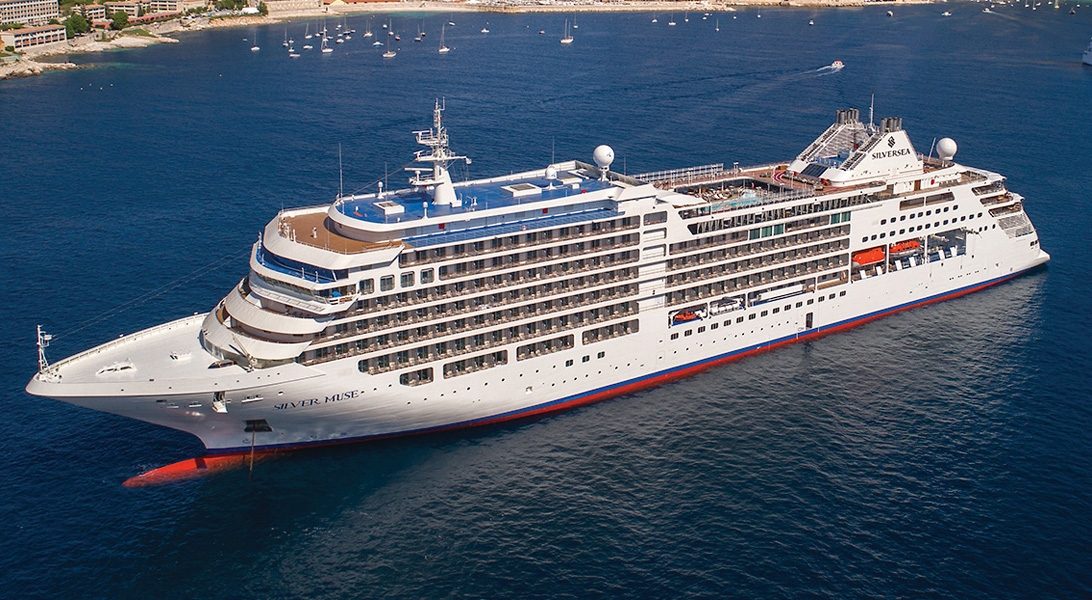
The images shown are for illustration purposes only and may not be an exact representation of what you find on the ship.
The images shown are for illustration purposes only and may not be an exact representation of what you find on the ship.
The images shown are for illustration purposes only and may not be an exact representation of what you find on the ship.
The images shown are for illustration purposes only and may not be an exact representation of what you find on the ship.
The images shown are for illustration purposes only and may not be an exact representation of what you find on the ship.
Our Fusion packages are all ABTA & ATOL protected ensuring that your booking is safe with us
| 141 nights aboard the Silver Dawn | |||
| Butler Service in Every Suite | |||
| Gratuities Always Included | |||
| Beverages In-Suite and Throughout the Ship | |||
| Gourmet Dining | |||
| In Suite Dining & 24-Hour Room Service | |||
| Intimate small size ships | |||
| Free Wifi Throughout the Ship | |||
| Free Zodiac, Land and Sea Tours & Activities & Complimentary Expedition gear | |||
| Port Taxes and Fees | |||
 | ABTA and ATOL Protection* | ||
Date 6th Jan 2026 |
Nts 141 |
Suite £85,800pp |
Date 6th Jan 2026 |
Nts 141 |
Suite £85,800pp |
| Suite staterooms from | £85,800pp | ||
| CV | Classic Veranda Suite |  | |
| DX | Deluxe Veranda Suite | £88,200pp | |
| G1 | Grand Suite (1 Bedroom) | | |
| G2 | Grand Suite (2 Bedrooms) | | |
| O1 | Owner's Suite (1 Bedroom) | | |
| O2 | Owner's Suite (2 Bedrooms) | | |
| PA | Panorama Suite | | |
| R1 | Royal Suite (1 Bedroom) | | |
| R2 | Royal Suite (2 Bedrooms) | | |
| S2 | Silver Suite (2 Bedrooms) | | |
| SL | Silver Suite | | |
| VI | Vista Suite | | |
| SV | Superior Veranda Suite | £85,800pp | |
Fusion Cruises when selling travel arrangements is a trading name of The Midcounties Co-operative Ltd. Fusion Cruises is an Accredited Body Member of Midcounties Co-operative Travel Consortium. (ABTA:P6652, ATOL:6053).
Book with Confidence. We are a Member of ABTA which means you have the benefit of ABTA’s assistance and Code of Conduct.
Some of the flights and flight-inclusive holidays on this website are financially protected by the ATOL scheme but ATOL protection does not apply to all holiday and travel services offered on this website. This website will provide you with information on the protection that applies in the case of each holiday and travel service offered before you make your booking. If you do not receive an ATOL Certificate then the booking will not be ATOL protected. If you do receive an ATOL Certificate but all parts of your trip are not listed on it, those parts will not be ATOL protected. Please see our booking conditions for information, or for more information about financial protection and the ATOL Certificate go to: www.caa.co.uk
